Category:Wegekreuz Maushöhle (Deidesheim)
Jump to navigation
Jump to search
| Object location | | View all coordinates using: OpenStreetMap |
|---|

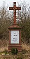
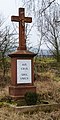
- Wayside cross at the northern end of the village west of the Weinstraße.
- Red sandstone, late 19th century.
Media in category "Wegekreuz Maushöhle (Deidesheim)"
The following 2 files are in this category, out of 2 total.
-
 006 2015 02 15 Kulturdenkmaeler Deidesheim.jpg 1,598 × 3,129; 4.49 MB
-
 007 2015 02 15 Kulturdenkmaeler Deidesheim.jpg 1,579 × 3,166; 4.5 MB

