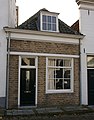
Category:Wellerondom 1, Brielle
Jump to navigation
Jump to search
| Object location | | View all coordinates using: OpenStreetMap |
|---|
building in Brielle, Netherlands  | |||||
| Upload media | |||||
| Instance of | |||||
|---|---|---|---|---|---|
| Location | Brielle, Voorne aan Zee, South Holland, Netherlands | ||||
| Street address |
| ||||
| Located on street | |||||
| Heritage designation |
| ||||
 | |||||
|
This is a category about rijksmonument number 10985
|
| Address |
|
Media in category "Wellerondom 1, Brielle"
The following 2 files are in this category, out of 2 total.
-
 Brielle - rijksmonument 10985 - Wellerondom 1 20111112.jpg 629 × 800; 213 KB
-
 Overzicht - Brielle - 20043445 - RCE.jpg 1,200 × 804; 177 KB
