Category:Wellington, Herefordshire
Jump to navigation
Jump to search
village in Herefordshire, England | |||||
| Upload media | |||||
| Instance of | |||||
|---|---|---|---|---|---|
| Location | Herefordshire, West Midlands, England | ||||
 | |||||
Cymraeg: Pentref yn Swydd Henffordd, Gorllewin Canolbarth Lloegr, Lloegr ydy Wellington. (→Wellington, Swydd Henffordd)
English: Wellington is a village in Herefordshire, England. The population of the village at the 2011 census was 1,005. (→Wellington, Herefordshire)
Polski: Wellington – wieś w Anglii, w hrabstwie Herefordshire. Leży 9 km na północ od miasta Hereford i 193 km na zachód od Londynu. (→Wellington (Herefordshire))

Subcategories
This category has the following 7 subcategories, out of 7 total.
Media in category "Wellington, Herefordshire"
The following 200 files are in this category, out of 316 total.
(previous page) (next page)-

-
 A49 at Burghope Farm - geograph.org.uk - 2956616.jpg 640 × 480; 48 KB
-
 A49 at Wellington Marsh - geograph.org.uk - 2956599.jpg 640 × 480; 56 KB
-
 A49 climbing by the woods on Dinmore Hill - geograph.org.uk - 5166736.jpg 1,600 × 1,200; 764 KB
-
 A49 looking north - geograph.org.uk - 4784910.jpg 1,600 × 901; 703 KB
-
 A49 looking south, 1 - geograph.org.uk - 4784912.jpg 1,600 × 901; 656 KB
-
 A49 looking south, 2 - geograph.org.uk - 4924951.jpg 1,600 × 900; 560 KB
-
 A49 near Burghope Farm - geograph.org.uk - 6313420.jpg 800 × 525; 84 KB
-
 A49 near Dinmore hill - geograph.org.uk - 4784921.jpg 1,600 × 901; 536 KB
-
 A49 near Marsh House Farm - geograph.org.uk - 6313150.jpg 800 × 600; 134 KB
-
 A49 near Wellington - geograph.org.uk - 4784898.jpg 1,600 × 901; 730 KB
-
 A49 northbound near Green farm - geograph.org.uk - 4141003.jpg 640 × 481; 44 KB
-
 A49 northbound near Wellington - geograph.org.uk - 2956608.jpg 640 × 481; 35 KB
-
 A49 towards Leominster - geograph.org.uk - 6313165.jpg 800 × 600; 70 KB
-
 A49 towards Leominster - geograph.org.uk - 6313203.jpg 800 × 600; 59 KB
-
 A49, Dinmore Hill - geograph.org.uk - 5520922.jpg 1,024 × 683; 357 KB
-
 Adzor Bank - geograph.org.uk - 1059117.jpg 640 × 370; 109 KB
-
 Adzor Bank - geograph.org.uk - 3800630.jpg 1,024 × 680; 297 KB
-
 Adzor Bank trig point - geograph.org.uk - 5898601.jpg 1,469 × 1,102; 679 KB
-
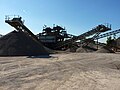 Aggregate sorting plant ^ conveyors in Wellington quarry - geograph.org.uk - 5898557.jpg 1,469 × 1,102; 600 KB
-
 Almshouses at Wellington - geograph.org.uk - 146269.jpg 640 × 426; 96 KB
-

-
 Along the lane towards Wellington village - geograph.org.uk - 5898616.jpg 1,102 × 1,469; 654 KB
-
 An early sign of spring - geograph.org.uk - 4784446.jpg 1,600 × 1,202; 853 KB
-
 Animal Farm at Wellington - geograph.org.uk - 5832334.jpg 3,648 × 2,736; 4.87 MB
-
 Animals at Wynnes Farm (Hope-Under-Dinmore) - geograph.org.uk - 5717410.jpg 3,264 × 2,448; 2.39 MB
-
 Arable land and Adzor Bank - geograph.org.uk - 4784431.jpg 1,600 × 901; 553 KB
-
 Arable land and Nupton Hill - geograph.org.uk - 4784432.jpg 1,600 × 901; 599 KB
-
 Arable land and wooded hills - geograph.org.uk - 4784923.jpg 1,600 × 901; 671 KB
-
 Arable land at Wellington - geograph.org.uk - 3814329.jpg 1,024 × 680; 251 KB
-
 Arable land in the Lugg valley - geograph.org.uk - 3389553.jpg 1,024 × 680; 208 KB
-
 Arboretum, Dinmore Hill - geograph.org.uk - 4468370.jpg 800 × 600; 519 KB
-
 Ashley House (Wellington) - geograph.org.uk - 5832929.jpg 2,048 × 1,360; 1.32 MB
-
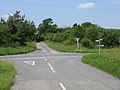 Auberrow Crossroads - geograph.org.uk - 1377079.jpg 640 × 480; 180 KB
-
 Auberrow Road - geograph.org.uk - 1059937.jpg 640 × 480; 131 KB
-
 Barn at Burghope Farm - geograph.org.uk - 4873596.jpg 4,254 × 2,254; 1.02 MB
-
 Barn, Burghope Farm - geograph.org.uk - 6314044.jpg 640 × 480; 55 KB
-
 Beans and oats - geograph.org.uk - 5898577.jpg 1,469 × 1,102; 797 KB
-
 Bodenham Road, 1 - geograph.org.uk - 4793323.jpg 1,600 × 901; 670 KB
-

-
 Bridge Lane, Wellington - geograph.org.uk - 1059962.jpg 479 × 640; 223 KB
-
 Buildings at Wellington Bridge - geograph.org.uk - 4873594.jpg 2,245 × 1,568; 490 KB
-
 Burghope - geograph.org.uk - 6318288.jpg 1,024 × 683; 276 KB
-
 Burghope Wood - geograph.org.uk - 6319096.jpg 1,024 × 683; 385 KB
-
 BurghopeCourt Wellington Herefordshire.jpg 1,024 × 683; 301 KB
-
 Buzz Lightyear at Wellington - geograph.org.uk - 5829229.jpg 1,920 × 1,080; 1.07 MB
-
 Cantona Cottage (Wellington) - geograph.org.uk - 5832863.jpg 3,648 × 2,736; 4.18 MB
-
 Chapel House (Wellington) - geograph.org.uk - 5832915.jpg 4,096 × 3,072; 4.87 MB
-
 Chapel, Wellington - geograph.org.uk - 4334997.jpg 800 × 600; 426 KB
-

-
 Christmas tree farm. Burghope. - geograph.org.uk - 146393.jpg 640 × 480; 119 KB
-
 Church Close (Wellington) - geograph.org.uk - 5832319.jpg 3,648 × 2,736; 4.61 MB
-
 Church of St Margaret, Wellington - geograph.org.uk - 5900603.jpg 1,795 × 1,346; 901 KB
-
 Churchyard at St. Margaret's Church (Wellington) - geograph.org.uk - 5832218.jpg 1,920 × 1,080; 1.02 MB
-
 Class 66 on a freight train at Wellington crossing - geograph.org.uk - 4262132.jpg 5,039 × 3,120; 3.47 MB
-

-
 Clun Castle at Wellington Crossing - geograph.org.uk - 6162592.jpg 3,190 × 2,098; 2.51 MB
-
 Corner End (Wellington) - geograph.org.uk - 5832857.jpg 3,648 × 2,736; 4.2 MB
-
 Corner of a field of beans - geograph.org.uk - 5898572.jpg 1,469 × 1,102; 770 KB
-
 Cottage in a churchyard - geograph.org.uk - 1060920.jpg 480 × 640; 227 KB
-
 Cottage in Wellington village - geograph.org.uk - 1060893.jpg 640 × 456; 127 KB
-
 Country road near Wellington - geograph.org.uk - 3389550.jpg 1,024 × 680; 159 KB
-
-
 Cream-coloured house - geograph.org.uk - 4784425.jpg 1,600 × 901; 710 KB
-
 Crop of rape - geograph.org.uk - 4784956.jpg 1,600 × 901; 690 KB
-
 Crops on the flanks of Wellington Wood - geograph.org.uk - 1981476.jpg 640 × 480; 228 KB
-
 Crossroads at Auberrow - geograph.org.uk - 3800757.jpg 1,024 × 680; 264 KB
-
 Crows at Wellington - geograph.org.uk - 5829200.jpg 1,920 × 1,080; 1.1 MB
-
 Daffodils at Queenswood Country Park (Hope-Under-Dinmore) - geograph.org.uk - 6084345.jpg 3,648 × 2,736; 4.34 MB
-
 Derndale House - geograph.org.uk - 672919.jpg 640 × 422; 68 KB
-
 Dinmore Woods - geograph.org.uk - 4468371.jpg 800 × 600; 546 KB
-
 Dinmore Woods - geograph.org.uk - 4468379.jpg 800 × 600; 530 KB
-
 Dinmore Woods - geograph.org.uk - 4468386.jpg 800 × 600; 529 KB
-

-

-

-
 Entrance to the Autumn Garden - geograph.org.uk - 621539.jpg 640 × 480; 151 KB
-
 Farm buildings and house - geograph.org.uk - 2475517.jpg 640 × 480; 90 KB
-
 Farm buildings at Wootton - geograph.org.uk - 5692514.jpg 640 × 480; 159 KB
-
 Farm buildings, Burghope Farm - geograph.org.uk - 6313207.jpg 800 × 493; 57 KB
-
 Farmland in the Wellington valley - geograph.org.uk - 2196841.jpg 1,024 × 768; 185 KB
-
 Farmland north of Wootton - geograph.org.uk - 2196851.jpg 1,024 × 768; 369 KB
-
 Farmland off Wellington Lane - geograph.org.uk - 1059130.jpg 640 × 480; 151 KB
-
 Farmland track - geograph.org.uk - 3800644.jpg 800 × 531; 135 KB
-
 Fenceline on the summit of Adzor Bank - geograph.org.uk - 5898592.jpg 1,469 × 1,102; 630 KB
-
 Field edge - geograph.org.uk - 4784965.jpg 1,600 × 901; 710 KB
-
 Field edge footpath - geograph.org.uk - 4784932.jpg 1,600 × 901; 723 KB
-
 Field edge near Wootton - geograph.org.uk - 4784961.jpg 1,600 × 901; 699 KB
-
 Field towards the River Lugg - geograph.org.uk - 6313198.jpg 800 × 600; 82 KB
-
 Field with oak tree - geograph.org.uk - 4793246.jpg 1,600 × 901; 603 KB
-

-
 Fields south of Wellington - geograph.org.uk - 4057911.jpg 640 × 360; 216 KB
-
 Flood water on a harvested field - geograph.org.uk - 3246106.jpg 1,024 × 680; 199 KB
-
 Fodder maize near Wellington - geograph.org.uk - 4057918.jpg 640 × 480; 325 KB
-
 Footbridge over Wellington Brook - geograph.org.uk - 1059986.jpg 640 × 480; 150 KB
-
 Footpath fork - geograph.org.uk - 4784947.jpg 1,600 × 901; 683 KB
-
 Footpath from Auberrow Road - geograph.org.uk - 4784439.jpg 1,600 × 901; 644 KB
-
 Footpath in Burghope Wood - geograph.org.uk - 4370661.jpg 531 × 800; 184 KB
-
 Footpath through Burghope Wood - geograph.org.uk - 4370649.jpg 1,024 × 680; 419 KB
-
 Ford at Wellington Brook - geograph.org.uk - 834339.jpg 480 × 640; 126 KB
-
 Ford in Bridge Lane, Wellington - geograph.org.uk - 1059976.jpg 640 × 480; 188 KB
-
 Ford Through Wellington Brook - geograph.org.uk - 1377115.jpg 480 × 640; 251 KB
-
 Ford, Wellington - geograph.org.uk - 4057543.jpg 640 × 480; 351 KB
-
 Forking footpaths - geograph.org.uk - 4793238.jpg 1,600 × 901; 745 KB
-
 Fountain, Hereford Garden Centre - geograph.org.uk - 1377121.jpg 640 × 480; 161 KB
-
 Freight train on Wellington Crossing - geograph.org.uk - 3246101.jpg 1,024 × 680; 161 KB
-
 Garden Centre, Wellington - geograph.org.uk - 708274.jpg 640 × 480; 85 KB
-

-
 Gate into the lake area - geograph.org.uk - 5690974.jpg 640 × 480; 190 KB
-
 Gates to Derndale House - geograph.org.uk - 672903.jpg 640 × 520; 82 KB
-
 Green lane to Adzor Bank - geograph.org.uk - 4784437.jpg 1,600 × 901; 737 KB
-
 Green Lane to Marden - geograph.org.uk - 4784891.jpg 1,600 × 901; 716 KB
-
 Hedgerow near Wellington - geograph.org.uk - 4784449.jpg 1,600 × 901; 706 KB
-
 Hereford Garden Centre - geograph.org.uk - 1248389.jpg 640 × 480; 96 KB
-
 Hereford Garden Centre, Wellington - geograph.org.uk - 834335.jpg 640 × 480; 92 KB
-
 Herefords in an orchard - geograph.org.uk - 4057587.jpg 640 × 480; 314 KB
-
 House at Wellington - geograph.org.uk - 2192030.jpg 1,024 × 768; 271 KB
-
 House at Wellington - geograph.org.uk - 4873591.jpg 3,635 × 2,361; 1.41 MB
-
 House at Wellington Marsh - geograph.org.uk - 4873589.jpg 2,588 × 2,185; 608 KB
-
 Houses below Wellington Wood - geograph.org.uk - 3814235.jpg 1,024 × 680; 321 KB
-
 Houses on Causeway Close, Wellington - geograph.org.uk - 6313160.jpg 800 × 600; 81 KB
-
 Humpty Dumpty at Old Watermill (Wellington) - geograph.org.uk - 5832941.jpg 2,048 × 1,360; 1.33 MB
-
 Isolated cottage - geograph.org.uk - 4784929.jpg 1,600 × 901; 644 KB
-
 Isolated tree in a field - geograph.org.uk - 4793234.jpg 1,600 × 901; 694 KB
-
 Isolated tree in a field, 2 - geograph.org.uk - 4793242.jpg 1,600 × 901; 725 KB
-
 Kipperknowle - geograph.org.uk - 4370669.jpg 800 × 531; 142 KB
-
 Lane heading south west, passing a house - geograph.org.uk - 5691008.jpg 640 × 480; 163 KB
-
 Lane heading towards the A49 - geograph.org.uk - 5690991.jpg 640 × 480; 129 KB
-

-
 Lane junction at Wootton - geograph.org.uk - 5692513.jpg 640 × 480; 216 KB
-
 Lane junction with the A49, looking east - geograph.org.uk - 5690995.jpg 640 × 480; 148 KB
-
 Lane north of Wellington, looking east - geograph.org.uk - 5692511.jpg 640 × 480; 129 KB
-
 Lane To Wellington - geograph.org.uk - 1377081.jpg 640 × 480; 185 KB
-
 Lane towards Upper Derndale - geograph.org.uk - 5898566.jpg 1,469 × 1,102; 723 KB
-
 Lay-by on A49 south of Dinmore Hill - geograph.org.uk - 5166732.jpg 1,600 × 1,201; 780 KB
-
 Layby on the A49 near Dinmore - geograph.org.uk - 2471331.jpg 640 × 480; 80 KB
-
 Level crossing, west of Walker's Green - geograph.org.uk - 6334592.jpg 3,659 × 2,109; 1.31 MB
-

-
 Long red brick barn, Wellington - geograph.org.uk - 1060926.jpg 640 × 395; 160 KB
-

-
 Lugg Valley From Dinmore Hill's Slopes - geograph.org.uk - 1365591.jpg 640 × 480; 175 KB
-
 Meadow at Wellington - geograph.org.uk - 2192060.jpg 1,024 × 767; 329 KB
-
 Memorial of Sir Herbert Perrott (Wellington) - geograph.org.uk - 5829333.jpg 3,648 × 2,736; 2.86 MB
-
 Minor road off the A49 - geograph.org.uk - 6313201.jpg 800 × 459; 45 KB
-
 Mr. Bean at Wellington Social Club - geograph.org.uk - 5829171.jpg 2,048 × 1,360; 1.38 MB
-
 Muddy lane heading south - geograph.org.uk - 5691010.jpg 640 × 480; 121 KB
-
 Muddy track within Burghope Wood - geograph.org.uk - 4793284.jpg 1,600 × 1,200; 980 KB
-
 Nott's House (Wellington) - geograph.org.uk - 5832217.jpg 1,920 × 1,080; 1.07 MB
-
 Nott's House (Wellington) - geograph.org.uk - 5832271.jpg 3,648 × 2,736; 5.09 MB
-
 Nott's House, Wellington - geograph.org.uk - 5666316.jpg 3,323 × 2,209; 2.6 MB
-
 Nupton Hill viewed from the east - geograph.org.uk - 3800743.jpg 1,024 × 680; 355 KB
-
 Oats on Adzor Bank - geograph.org.uk - 5898586.jpg 1,469 × 1,102; 655 KB
-
 Oilseed rape, Wellington - geograph.org.uk - 4057590.jpg 640 × 480; 325 KB
-
 Old entrance to gravel pits off the A49 - geograph.org.uk - 6313153.jpg 800 × 493; 115 KB
-
 Old Watermill (Wellington) - geograph.org.uk - 5832935.jpg 2,048 × 1,360; 1.34 MB
-
 Old Watermill (Wellington) - geograph.org.uk - 5832949.jpg 4,096 × 3,072; 4.2 MB
-
 OS benchmark - Wellington, tower of St Margaret's Church - geograph.org.uk - 5898757.jpg 1,102 × 1,469; 1.07 MB
-
 OS flush bracket - Adzor Bank trig - geograph.org.uk - 5898611.jpg 1,049 × 1,380; 891 KB
-
 Panorama Toward Nupton Hill - geograph.org.uk - 1377078.jpg 640 × 480; 185 KB
-
 Pasture and woodland - geograph.org.uk - 4793260.jpg 1,600 × 901; 698 KB
-
 Path through Wellington Wood - geograph.org.uk - 2196826.jpg 1,024 × 768; 485 KB
-
 Path, Burghope Wood - geograph.org.uk - 6319094.jpg 1,024 × 683; 387 KB
-
 Queen's Wood - geograph.org.uk - 4377904.jpg 800 × 531; 196 KB
-
 Queenswood Country Park (Hope-Under-Dinmore) - geograph.org.uk - 6084336.jpg 3,648 × 2,736; 3.67 MB
-
 Queenswood Country Park (Hope-Under-Dinmore) - geograph.org.uk - 6084341.jpg 3,648 × 2,736; 3.96 MB
-
 Queenswood Country Park (Hope-Under-Dinmore) - geograph.org.uk - 6084343.jpg 3,648 × 2,736; 4 MB
-
 Queenswood Country Park (Hope-Under-Dinmore) - geograph.org.uk - 6084383.jpg 2,736 × 3,648; 3.35 MB
-

-
 Road towards Park Cottages - geograph.org.uk - 6313194.jpg 800 × 600; 73 KB
-
 Road towards Wellington village - geograph.org.uk - 6313161.jpg 800 × 600; 72 KB
-
 Road, Dinmore - geograph.org.uk - 5007441.jpg 640 × 427; 174 KB
-
 Scarecrow at Queenswood Close (Wellington) - geograph.org.uk - 5829197.jpg 1,920 × 1,080; 1,023 KB
-
 Scarecrow at Wellington - geograph.org.uk - 5829169.jpg 2,048 × 1,360; 1.42 MB
-
 Scarecrow at Wellington - geograph.org.uk - 5829189.jpg 1,920 × 1,080; 1.04 MB
-
 Seedheads of Clematis vitalba - geograph.org.uk - 4793316.jpg 1,600 × 1,201; 985 KB
-
 Seriously constrained footpath - geograph.org.uk - 4057569.jpg 640 × 853; 621 KB
-
 Sheep grazing in a shallow re-entrant - geograph.org.uk - 5898589.jpg 1,469 × 1,102; 555 KB
-
 Sheep in field below Adzor Bank trig - geograph.org.uk - 5898613.jpg 1,469 × 1,102; 614 KB
-
 Sheep pasture west of Wellington - geograph.org.uk - 2192048.jpg 1,024 × 768; 303 KB
-
 Sign at St. Margaret's Church (Wellington) - geograph.org.uk - 5832331.jpg 3,648 × 2,736; 4.51 MB
-
 Sign at The Rickyard (Wellington) - geograph.org.uk - 5829207.jpg 1,920 × 1,080; 1.07 MB
-

-
 Specimen oak tree - geograph.org.uk - 4793243.jpg 1,600 × 1,200; 906 KB
-
 St Margaret of Antioch, Wellington - geograph.org.uk - 5666441.jpg 3,323 × 2,209; 2.53 MB
-
 St Margaret of Antioch, Wellington - geograph.org.uk - 5666474.jpg 2,209 × 3,323; 2.28 MB
-
 St Margaret of Antioch, Wellington - geograph.org.uk - 5666588.jpg 2,209 × 3,323; 2.64 MB
-
 St Margaret of Antioch, Wellington - geograph.org.uk - 5666594.jpg 2,208 × 3,324; 2 MB
-
 St Margaret of Antioch, Wellington - geograph.org.uk - 5667126.jpg 2,198 × 3,339; 2.51 MB
-
 St Margaret of Antioch, Wellington - geograph.org.uk - 5667220.jpg 2,209 × 3,322; 2.16 MB
-
 St Margaret of Antioch, Wellington - geograph.org.uk - 5667980.jpg 2,209 × 3,323; 1.72 MB
-
 St Margaret of Antioch, Wellington - geograph.org.uk - 5667990.jpg 3,323 × 2,209; 1.86 MB
-
 St Margaret of Antioch, Wellington - geograph.org.uk - 5668003.jpg 2,209 × 3,323; 1.82 MB
-
 St Margaret of Antioch, Wellington - geograph.org.uk - 5668010.jpg 2,810 × 2,612; 1.41 MB
-
 St Margaret of Antioch, Wellington - geograph.org.uk - 5668014.jpg 3,323 × 2,209; 1.7 MB
-
 St. Margaret's Church (Bell Tower ^ Wellington) - geograph.org.uk - 5829232.jpg 1,920 × 1,080; 1.09 MB
-
 St. Margaret's Church (Bell Tower ^ Wellington) - geograph.org.uk - 5829241.jpg 3,648 × 2,736; 4.62 MB
-
 St. Margaret's Church (Bell Tower ^ Wellington) - geograph.org.uk - 5829254.jpg 3,648 × 2,736; 4.73 MB
-
 St. Margaret's Church (Bell Tower ^ Wellington) - geograph.org.uk - 5832266.jpg 2,048 × 1,536; 1.72 MB
-
 St. Margaret's Church (Chancel ^ Wellington) - geograph.org.uk - 5829325.jpg 2,048 × 1,152; 1.17 MB
-
 St. Margaret's Church (North Transept ^ Wellington) - geograph.org.uk - 5829316.jpg 1,920 × 1,080; 1.02 MB


_-_geograph.org.uk_-_5717410.jpg)


_-_geograph.org.uk_-_5832929.jpg)


_-_geograph.org.uk_-_5832257.jpg)


_-_geograph.org.uk_-_5832863.jpg)
_-_geograph.org.uk_-_5832915.jpg)

_-_geograph.org.uk_-_6084340.jpg)

_-_geograph.org.uk_-_5832319.jpg)

_-_geograph.org.uk_-_5832218.jpg)


_-_geograph.org.uk_-_5832857.jpg)


_-_geograph.org.uk_-_6084345.jpg)


_-_geograph.org.uk_-_6084376.jpg)


_-_geograph.org.uk_-_5832941.jpg)


_-_geograph.org.uk_-_5829333.jpg)


_-_geograph.org.uk_-_5832217.jpg)
_-_geograph.org.uk_-_5832271.jpg)


_-_geograph.org.uk_-_5832935.jpg)
_-_geograph.org.uk_-_5832949.jpg)


_-_geograph.org.uk_-_6084336.jpg)
_-_geograph.org.uk_-_6084341.jpg)
_-_geograph.org.uk_-_6084343.jpg)
_-_geograph.org.uk_-_6084383.jpg)


_-_geograph.org.uk_-_5829197.jpg)


_-_geograph.org.uk_-_5832331.jpg)
_-_geograph.org.uk_-_5829207.jpg)
_-_geograph.org.uk_-_6084359.jpg)


_-_geograph.org.uk_-_5829232.jpg)
_-_geograph.org.uk_-_5829241.jpg)
_-_geograph.org.uk_-_5829254.jpg)
_-_geograph.org.uk_-_5832266.jpg)
_-_geograph.org.uk_-_5829325.jpg)
_-_geograph.org.uk_-_6084379.jpg)
_-_geograph.org.uk_-_5829316.jpg)