Category:Welser Höhenweg
Jump to navigation
Jump to search
hiking trail in Upper Austria  | |||||
| Upload media | |||||
| Instance of | |||||
|---|---|---|---|---|---|
| Location | Upper Austria, Austria | ||||
| Start point | |||||
| Destination point | |||||
| Length |
| ||||
| Mountain range | |||||
 | |||||
Media in category "Welser Höhenweg"
The following 6 files are in this category, out of 6 total.
-
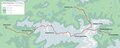 Höhenweg Übersichtskarte2.pdf 8,291 × 3,316; 1.2 MB
-
 Höhenweg Übersichtskarte4X.pdf 8,291 × 3,316; 991 KB
-
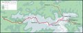
 Höhenweg Übersichtskarte4X.svg 4,975 × 1,991; 394 KB
-
 Startpunkt Almtal.jpg 2,472 × 1,637; 1.5 MB
-
 Tafel Welser Höhenweg.JPG 1,024 × 768; 357 KB
-
 Welser Höhenweg - Startpunkt Hinterstoder.jpg 1,248 × 924; 478 KB


