Category:Western lodge, Flaybrick Memorial Gardens
Jump to navigation
Jump to search
| Object location | | View all coordinates using: OpenStreetMap |
|---|
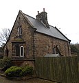
grade II listed cemetery lodge, Birkenhead, Wirral, Merseyside, England, UK  | |||||
| Upload media | |||||
| Instance of | |||||
|---|---|---|---|---|---|
| Location | Flaybrick Memorial Gardens, Birkenhead, Wirral, Merseyside, North West England, England | ||||
| Heritage designation |
| ||||
 | |||||
Media in category "Western lodge, Flaybrick Memorial Gardens"
The following 3 files are in this category, out of 3 total.
-
 Lodge by secondary western gates, Flaybrick Hill Cemetery.jpg 3,270 × 3,416; 2.5 MB
-

-
 Western lodge, Flaybrick Memorial Gardens.jpg 4,976 × 3,391; 22.94 MB

