Category:Westerwalstraat 35, Elburg
Jump to navigation
Jump to search
| Object location | | View all coordinates using: OpenStreetMap |
|---|
 | |||||
| Upload media | |||||
| Instance of | |||||
|---|---|---|---|---|---|
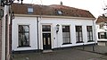
| Location | Elburg, Gelderland, Netherlands | ||||
| Street address |
| ||||
| Located on street |
| ||||
| Heritage designation |
| ||||
 | |||||
|
This is a category about rijksmonument number 14883
|
| Address |
|
Media in category "Westerwalstraat 35, Elburg"
The following 4 files are in this category, out of 4 total.
-
 Elburg - Beekstraat - View SW I.jpg 2,592 × 3,915; 11.43 MB
-
 Elburg - Nunspeterweg - View NE towards Beekstraat.jpg 3,915 × 2,592; 12.1 MB
-
 Elburg - panoramio (29).jpg 3,264 × 4,928; 4.76 MB
-
 Elburg- Westerwalstraat 35.JPG 3,840 × 2,160; 2.09 MB


.jpg)