Category:Weston, Massachusetts
Jump to navigation
Jump to search
town in Middlesex County, Massachusetts, United States    | |||||
| Upload media | |||||
| Instance of | |||||
|---|---|---|---|---|---|
| Part of | |||||
| Location | Middlesex County, Massachusetts | ||||
| Inception |
| ||||
| Population |
| ||||
| Area |
| ||||
| Elevation above sea level |
| ||||
| official website | |||||
 | |||||
Subcategories
This category has the following 16 subcategories, out of 16 total.
B
- Bridges in Weston, Massachusetts (13 F)
C
- Case Estates (3 F)
L
- Lanson Park (2 F)
M
N
P
R
W
- Weston Ski Track (5 F)
- Weston Town Hall (2 F)
Media in category "Weston, Massachusetts"
The following 37 files are in this category, out of 37 total.
-
 Seal of Weston, Massachusetts.svg 222 × 223; 81 KB
-
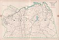 1908 map of Weston, Massachusetts.jpg 5,000 × 3,435; 4.36 MB
-
 Along the Boston Post Rd, Weston MA.JPG 2,048 × 1,536; 1.43 MB
-

-
 Boston Post Road, Weston MA.jpg 3,264 × 2,448; 3.6 MB
-
 Breakfast Sausage, Ye Olde Cottage Restaurant, Weston MA.jpg 3,264 × 2,448; 1.64 MB
-
 Bridge at east end of MCRT Wayside, Weston MA.jpg 4,032 × 3,024; 5.86 MB
-
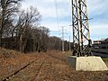 Central Mass ROW in Weston, April 2017.JPG 4,320 × 3,240; 3.85 MB
-
 Central Mass tracks in Weston, April 2017.JPG 4,320 × 3,240; 4.29 MB
-

-

-
 Charles from Norumbega Park.agr.jpg 3,264 × 2,448; 1.91 MB
-

-
 Destroyed Central Mass track in Weston, April 2017.JPG 4,320 × 3,240; 4.66 MB
-

-
 Knox-ma24-weston.jpg 2,448 × 3,264; 2.39 MB
-
 Land's Sake Farm, Weston MA.jpg 2,272 × 1,704; 1.73 MB
-
 Massachusetts turnpike toll booth - panoramio.jpg 2,592 × 1,936; 922 KB
-
 MBTA train with D&H locomotive crossing Route 128, June 1978.jpg 1,097 × 718; 887 KB
-
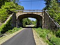 MCRT Wayside, Concord Road underpass, Weston MA.jpg 4,032 × 3,024; 7.46 MB
-
 MCRT Wayside, Weston MA.jpg 4,032 × 3,024; 4.61 MB
-

-
 RobertWinsor.jpg 156 × 215; 47 KB
-
 Solar panel array Weston aerial.JPG 6,000 × 4,000; 11.29 MB
-
 Stony Brook at Viles Street, Weston MA.jpg 4,032 × 3,024; 6.86 MB
-
 The woods and by-ways of New England (1872) (14776299091).jpg 2,004 × 1,444; 1.25 MB
-
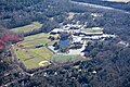 Weston High School aerial.JPG 6,000 × 4,000; 11.63 MB
-
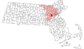 Weston ma highlight.png 788 × 466; 55 KB
-
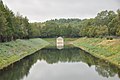
 Weston Reservoir P1090738.jpg 2,560 × 1,920; 2.2 MB
-
 Weston Reservoir P1090746.jpg 2,560 × 1,920; 1.71 MB
-
 Weston Ski Track 125 2556.jpg 1,024 × 768; 488 KB
-
 Weston Toll Plaza.jpg 800 × 533; 100 KB
-
 WestonAqueduct ChannelChamber.jpg 1,024 × 680; 214 KB
-
 WestonHighSchoolMA.jpg 208 × 207; 17 KB
-
 WestonMA GlenRoadHD.jpg 1,024 × 680; 260 KB
-
 WestonMA WellingtonFarmHD.jpg 1,024 × 680; 260 KB
-
 WestonReservoir.jpg 3,008 × 2,000; 2.31 MB


_(14781855404).jpg)
_(14582076458).jpg)

,_Weston,_Mass_-_DPLA_-_e62b0e730110447cb23239f4a3e0336e.jpg)


_(14776299091).jpg)


