Category:Westwagenstraat 1, Gorinchem
Jump to navigation
Jump to search
| Object location | | View all coordinates using: OpenStreetMap |
|---|
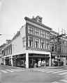
building in Gorinchem, Netherlands  | |||||
| Upload media | |||||
| Instance of | |||||
|---|---|---|---|---|---|
| Location | Gorinchem, South Holland, Netherlands | ||||
| Street address |
| ||||
| Located on street |
| ||||
| Heritage designation |
| ||||
 | |||||
|
This is a category about rijksmonument number 16677
|
| Address |
|
Media in category "Westwagenstraat 1, Gorinchem"
The following 3 files are in this category, out of 3 total.
-
 Exterieur VOORGEVEL, LINKER ZIJGEVEL - Gorinchem - 20276798 - RCE.jpg 958 × 1,200; 230 KB
-
 Gorinchem - rijksmonument 16677 - Westwagenstraat 1 20120311.jpg 587 × 800; 207 KB
-
 Voorgevel - Gorinchem - 20081134 - RCE.jpg 807 × 1,200; 205 KB

