Category:White Place (Bloomington, Illinois)
Jump to navigation
Jump to search
| Object location | | View all coordinates using: OpenStreetMap |
|---|
historic district in Illinois, United States  | |||||
| Upload media | |||||
| Instance of | |||||
|---|---|---|---|---|---|
| Location | Illinois | ||||
| Heritage designation |
| ||||
 | |||||
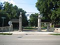
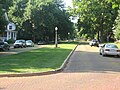
White Place (White Pl.) is a 600 meter long (0.38 mile / 2000 foot long) residential brick street with median in Bloomington, Illinois. It runs parallel on the west side of Constitution Trail. The north end is at Sugar Creek just north of E. Emerson St.; the south end is at E. Empire St. (US 150/IL 9 westbound). White Place and the next two streets to the west are designated as a historic site named the White Place Historic District.
Media in category "White Place (Bloomington, Illinois)"
The following 7 files are in this category, out of 7 total.
-
 WhitePlace 2231.jpg 2,592 × 1,944; 2.97 MB
-
 WhitePlace 2232.jpg 2,592 × 1,944; 2.51 MB
-
 WhitePlace 2233.jpg 2,592 × 1,944; 2.8 MB
-
 WhitePlace 2234.jpg 2,592 × 1,944; 2.36 MB
-
 WhitePlace 2235.jpg 2,592 × 1,944; 2.5 MB
-
 WhitePlace 2236.jpg 2,592 × 1,944; 2.71 MB
-
 WhitePlace 2237.jpg 2,592 × 1,944; 2.11 MB


