Category:Whites Butte
Jump to navigation
Jump to search


(& Views of Pima Point-(left), Columbus Point-(center))
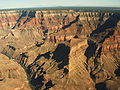
English: Whites Butte-(a massive ridgeline terminus-(a massif)), adjacent the Colorado River (south side, Granite Gorge), at the terminus of Travertine Canyon, on its west-northwest side; w:Whites Butte also lies in Lower Boucher Canyon, on its southeast side.
- Whites Butte is on a series of ridgeline termini, upstream from Scorpion Ridge, below Point Imperial (Colorado River, north side). From upstream, the 3 ridgeline termini are Whites Butte, Marsh Butte, and Geikie Peak.
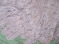
- The Boucher Trail traverses the west flank of Whites Butte, after going over the saddle at the south terminus of Whites Butte & between the base of the cliffs of w:Cocopa Point. The w:Boucher Trail then intersects the Tonto Trail in Lower Boucher Canyon, on its southeast side-(also the location of the intersection of the w:Topaz Canyon terminus, the east tributary to Boucher Canyon).
- The prominence of the butte is composed of eroded Supai Group redbeds (Watahomigi Formation), sitting on a flat platform of Redwall Limestone.
Landform in the Grand Canyon | |||||
| Upload media | |||||
| Location | Arizona | ||||
|---|---|---|---|---|---|
 | |||||
Subcategories
This category has the following 2 subcategories, out of 2 total.
W
- Whites Butte (east aspect) (3 F)
- Whites Butte (west aspect) (1 F)
Media in category "Whites Butte"
The following 16 files are in this category, out of 16 total.
-
 Arizona. LOC 99446124-3.jpg 6,534 × 8,020; 11.28 MB
-
 Arizona. LOC 99446125-1.jpg 6,435 × 7,934; 9.86 MB
-
 Arizona. LOC 99446126-2.jpg 5,014 × 6,252; 6.24 MB
-
 Eremita Mesa, Cocopa Point, Travertine and Boucher Canyons.png 1,125 × 2,001; 11.53 MB
-

-
 Grand Canyon.jpg 1,600 × 1,200; 357 KB
-
 GrandCanyon-micio-2.jpg 1,600 × 1,200; 679 KB
-
 Harvey Butchart's hiking map - Flickr - brewbooks (6).jpg 3,264 × 2,448; 4.13 MB
-
 NPS grand-canyon-topo-map.jpg 8,420 × 4,819; 8.89 MB
-
 Scorpion Ridge.jpg 3,199 × 2,125; 1.57 MB
-
 Traveller (2242014640).jpg 3,008 × 1,801; 4.85 MB
-
 USA 09828 Grand Canyon Luca Galuzzi 2007.jpg 2,000 × 1,333; 2.6 MB
-
 Vue aérienne sur le Grand Canyon (9045759114).jpg 2,848 × 4,282; 13.35 MB
-
 Vue aérienne sur le Grand Canyon (9051728732).jpg 4,282 × 2,848; 10.71 MB
-
 Whites Butte, East Aspect, West Ridgeline of Scorpion Ridge.png 1,125 × 2,001; 10.25 MB
-
 Whites Butte, Hermit Rapids on Colorado River, Granite Gorge.png 1,125 × 2,001; 11.49 MB


.jpg)


.jpg)

.jpg)
.jpg)
