Category:Wielfresen
Jump to navigation
Jump to search
former municipality in Austria  | |||||
| Upload media | |||||
| Instance of |
| ||||
|---|---|---|---|---|---|
| Location | |||||
| Area |
| ||||
| Elevation above sea level |
| ||||
 | |||||
Subcategories
This category has the following 7 subcategories, out of 7 total.
Media in category "Wielfresen"
The following 28 files are in this category, out of 28 total.
-
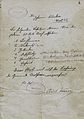 60 kg Stroh Bezugsschein Wielfresen.jpg 4,866 × 6,918; 31.05 MB
-
 Aufnahmeblatt 5254-4 1878.jpg 9,684 × 7,366; 33.08 MB
-
 AUT Wielfresen COA.jpg 450 × 549; 81 KB
-
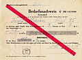 Bedarfsnachweis Mehl Gemeinde Wiel 1959.jpg 4,887 × 3,565; 24.42 MB
-
 Fahrpläne Deutschlandsberg Schwanberg Wies 1975-76.jpg 10,573 × 8,327; 12.51 MB
-
 Franziszeische Landesaufnahme Landsberg Osterwitz.jpg 7,632 × 6,962; 17.93 MB
-
 Franziszeische Landesaufnahme Weineben Glashütten.JPEG 7,680 × 6,983; 18.48 MB
-
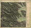
 Geologische Karte Unterdrauburg 1926.jpg 11,909 × 9,764; 65.31 MB
-
 Hermann Carl Russ Südweg 2005.jpg 561 × 1,024; 512 KB
-
 Jokabauer Unterfresen von Westen.jpg 2,896 × 1,944; 4.55 MB
-
 Jokabauer Unterfresen von Westen2.jpg 2,896 × 1,944; 3.55 MB
-
 Map at wielfresen.png 400 × 240; 3 KB
-
 Pfarrerhebungen 1892-50.jpg 5,100 × 7,019; 23.51 MB
-
 Pfarrerhebungen 1892-52.jpg 5,100 × 7,019; 19.37 MB
-
 Sankt Katharina id Wiel 294A0860 Steiermark.jpg 5,001 × 3,334; 2.53 MB
-
 St Katharina in der Wiel Bildstock.jpg 1,944 × 2,896; 4.33 MB
-
 St Katharina in der Wiel Friedhof.jpg 2,896 × 1,944; 7.9 MB
-
 St Katharina in der Wiel G'fangana Russ'.jpg 2,896 × 1,944; 3.73 MB
-
 St Katharina in der Wiel Ortsschild Wielfresen.jpg 2,896 × 1,944; 5.84 MB
-
 St Katharina in der Wiel Spenderschild Geläute.jpg 2,896 × 1,944; 3.44 MB
-
 St Katharina in der Wiel Straßenbildstock.jpg 1,944 × 2,896; 3.44 MB
-
 St Katharina Wiel Bildstock.jpg 1,944 × 2,896; 3.31 MB
-
 Unterfresen Hausbäume vlg Jokabauer.jpg 1,944 × 2,896; 4.27 MB
-
 Unterfresen vom Jokabauer Richtung Südwesten.jpg 2,896 × 1,944; 3.91 MB
-
 Wegschild Jokabauer Unterfresen.jpg 2,896 × 1,944; 2.35 MB
-
 Wernersdorf von Unterfresen Ri Wiel Pfarrkirche.jpg 2,896 × 1,944; 2.99 MB
-
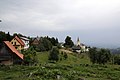
 Wielfresen 294A2674 Styria.jpg 5,001 × 3,334; 10.84 MB
-
 Wielfresen im Bezirk DL.png 645 × 645; 29 KB


