Category:Wierde 2, Leens
Jump to navigation
Jump to search
| Object location | | View all coordinates using: OpenStreetMap |
|---|
 | |||||
| Upload media | |||||
| Instance of |
| ||||
|---|---|---|---|---|---|
| Location | Leens, Leens | ||||
| Located on street |
| ||||
| Heritage designation |
| ||||
 | |||||
|
This is a category about rijksmonument number 526151
|
| Address |
|
Media in category "Wierde 2, Leens"
The following 36 files are in this category, out of 36 total.
-
 Achterzijde met ingang - Leens - 20335731 - RCE.jpg 1,187 × 1,200; 398 KB
-
 Beeld in tuin - Leens - 20335740 - RCE.jpg 1,195 × 1,200; 398 KB
-
 File-Leens - Wierde 2 (detail nis).jpg 148 × 521; 20 KB
-
 File-Leens - Wierde 2 (detail raam).jpg 308 × 646; 37 KB
-
 File-Leens - Wierde 2 (detail topgevel).jpg 792 × 759; 85 KB
-
 Gedeelte rechter zijgevel met zij-ingang - Leens - 20335728 - RCE.jpg 1,183 × 1,200; 422 KB
-
 Ingangspartij - Leens - 20335725 - RCE.jpg 1,194 × 1,200; 259 KB
-
 Interieur hal met deur - Leens - 20335779 - RCE.jpg 1,186 × 1,200; 154 KB
-
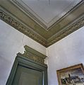
 Interieur kamer, detail plafond - Leens - 20352073 - RCE.jpg 1,189 × 1,200; 137 KB
-
 Interieur koof met bed - Leens - 20335786 - RCE.jpg 1,190 × 1,200; 171 KB
-
 Interieur verdieping, kozijn met opstapje - Leens - 20352084 - RCE.jpg 1,191 × 1,200; 162 KB
-
 Interieur voorkamer, detail stucplafond - Leens - 20335752 - RCE.jpg 1,188 × 1,200; 276 KB
-

-
 Interieur zolder met houtconstructie - Leens - 20352064 - RCE.jpg 1,189 × 1,200; 228 KB
-
 Interieur, gedeelte voorkamer met tussendeur - Leens - 20335751 - RCE.jpg 1,187 × 1,200; 178 KB
-
 Interieur, glas in loodraam - Leens - 20335781 - RCE.jpg 1,199 × 1,200; 182 KB
-
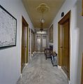 Interieur, overzicht gang - Leens - 20335774 - RCE.jpg 1,188 × 1,200; 197 KB
-
 Interieur, overzicht kapconstructie - Leens - 20352072 - RCE.jpg 1,189 × 1,200; 245 KB
-
 Interieur, overzicht serre - Leens - 20335764 - RCE.jpg 1,187 × 1,200; 211 KB
-
 Interieur, overzicht voorkamer - Leens - 20335741 - RCE.jpg 1,187 × 1,200; 253 KB
-
 Interieur, voorkamer met schouw - Leens - 20335765 - RCE.jpg 1,195 × 1,200; 241 KB
-
 Leens - Wierde 2.jpg 3,023 × 2,268; 2.46 MB
-
 Linker zijgevel, deur met stucwerk - Leens - 20335733 - RCE.jpg 1,189 × 1,200; 348 KB
-
 Overzicht achtertuin - Leens - 20335732 - RCE.jpg 1,185 × 1,200; 418 KB
-
 Overzicht linker zijgevel - Leens - 20335730 - RCE.jpg 1,191 × 1,200; 380 KB
-
 Overzicht tuin met beeld - Leens - 20335739 - RCE.jpg 1,194 × 1,200; 429 KB
-
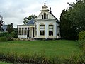
 Overzicht vanaf de weg - Leens - 20335721 - RCE.jpg 1,189 × 1,200; 288 KB
-
 Overzicht vijver - Leens - 20335738 - RCE.jpg 1,189 × 1,200; 457 KB
-
 Overzicht voorgevel - Leens - 20335722 - RCE.jpg 1,185 × 1,200; 331 KB
-
 Raam, detail stucwerk - Leens - 20335736 - RCE.jpg 1,197 × 1,200; 237 KB
-
 Raam, detail stucwerk - Leens - 20335737 - RCE.jpg 1,195 × 1,200; 189 KB
-
 Rechter zijgevel, stucwerk rondom de ramen - Leens - 20335727 - RCE.jpg 1,188 × 1,200; 373 KB
-
 Voorgevel - Leens - 20335723 - RCE.jpg 1,191 × 1,200; 387 KB
-
 Voorgevel met uitbouw - Leens - 20335724 - RCE.jpg 1,186 × 1,200; 388 KB
-
 Voorgevel, detail stucwerk - Leens - 20335735 - RCE.jpg 1,197 × 1,200; 300 KB
-
 Wierde 2 Leens.jpg 2,879 × 2,214; 1.36 MB


.jpg)
.jpg)


.jpg)