Category:Witte Kerkje, Noordwijkerhout
Jump to navigation
Jump to search
| Object location | | View all coordinates using: OpenStreetMap |
|---|
protestant church  | |||||
| Upload media | |||||
| Instance of | |||||
|---|---|---|---|---|---|
| Location | Noordwijkerhout, South Holland, Netherlands | ||||
| Street address |
| ||||
| Located on street |
| ||||
| Heritage designation |
| ||||
| Religion or worldview | |||||
 | |||||
|
This is a category about rijksmonument number 30770
|
| Address |
|
Media in category "Witte Kerkje, Noordwijkerhout"
The following 29 files are in this category, out of 29 total.
-
 Exterieur naar het noord-oosten - Noordwijkerhout - 20169736 - RCE.jpg 953 × 1,200; 226 KB
-
 Exterieur naar het noord-westen - Noordwijkerhout - 20169738 - RCE.jpg 966 × 1,200; 287 KB
-
 Exterieur naar het zuid-westen - Noordwijkerhout - 20169737 - RCE.jpg 960 × 1,200; 249 KB
-
 Exterieur zuid-oost zijde - Noordwijkerhout - 20169745 - RCE.jpg 964 × 1,200; 206 KB
-
 Gezicht op Noordwijkerhout in 1657 PK-T-2848, PK-T-AW-3267.jpg 357 × 261; 35 KB
-
 Interieur naar het oosten - Noordwijkerhout - 20169739 - RCE.jpg 954 × 1,200; 161 KB
-
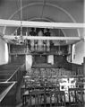 Interieur naar het westen - Noordwijkerhout - 20169740 - RCE.jpg 954 × 1,200; 203 KB
-

-
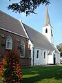
 Kerk vanuit het noord-oosten - Noordwijkerhout - 20169734 - RCE.jpg 902 × 1,200; 165 KB
-
 Kerk vanuit het zuid-westen - Noordwijkerhout - 20169735 - RCE.jpg 888 × 1,200; 142 KB
-
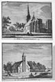 Naar een gravure in Verheerlijkt Nederland - Langeveld - 20128966 - RCE.jpg 798 × 1,200; 312 KB
-
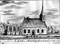
 Noordwijkerhout karkjen.jpg 375 × 500; 59 KB
-
 Noordwijkerhout Witte Kerkje.JPG 2,086 × 3,135; 3 MB
-
 Noordwijkerhout, de Witte Kerk RM30770 foto3 2014-04-13 12.32.jpg 3,312 × 4,416; 9.5 MB
-
 Noordwijkerhout, the Witte Kerkje.jpg 1,752 × 2,551; 1.14 MB
-
 Noordwijkerhout, Witte Kerkje (1).jpg 3,292 × 2,667; 2 MB
-
 Noordwijkerhout, Witte Kerkje (2).jpg 3,246 × 2,874; 1.81 MB
-
 Noordwijkerhout, Witte Kerkje (3).jpg 3,222 × 2,944; 2.06 MB
-
 Noordwijkerhout, Witte Kerkje (4).jpg 2,920 × 2,962; 1.68 MB
-
 Noordwijkerhout, Witte Kerkje (5).jpg 3,030 × 2,854; 1.26 MB
-

-

-

-

-
 Toren - Noordwijkerhout - 20169743 - RCE.jpg 952 × 1,200; 297 KB
-
 Volle maan, Noordwijkerhout — 10122011-10122011-SPR 5437-2.jpg 2,682 × 4,032; 4.96 MB
-
 Volle maan, Noordwijkerhout — 10122011-SPR 5437 (Large).jpg 718 × 1,080; 88 KB
-
 Zuid-west zijde, exterieur - Noordwijkerhout - 20169744 - RCE.jpg 955 × 1,200; 178 KB
-
 Zuidoostgevel en kerktoren - Noordwijkerhout - 20169742 - RCE.jpg 894 × 1,200; 227 KB


.jpg)
.jpg)
.jpg)
.jpg)
.jpg)


.jpg)

