Category:Woronora Dam
Jump to navigation
Jump to search
| Object location | | View all coordinates using: OpenStreetMap |
|---|
dam on the Woronora River in Australia  | |||||
| Upload media | |||||
| Instance of | |||||
|---|---|---|---|---|---|
| Location |
| ||||
| Heritage designation |
| ||||
| Elevation above sea level |
| ||||
| Reservoir created |
| ||||
 | |||||
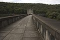
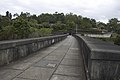
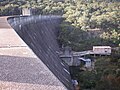
English: Woronora Dam is an heritage-listed concrete gravity dam with an uncontrolled serpentine spillway across the Woronora River, located south of Greater Metropolitan Sydney, in the suburb of Woronora Dam, Sutherland Shire, New South Wales, Australia. The principal purpose of the dam is for potable water supply for Sydney's southern suburbs and the northern suburbs of the Illawarra region. The impounded 71,790-megalitre (2,535×106 cu ft) reservoir is also called Woronora Dam and is sometimes incorrectly called Lake Woronora. The dam was designed by G. E. Haskins, Chief Engineer and the Metropolitan Water, Sewerage and Drainage Board of NSW (MWS&BD) and built from 1927 to 1941 by the MWS&BD.
Media in category "Woronora Dam"
The following 58 files are in this category, out of 58 total.
-
 Common tree snake woronora dam.jpg 2,179 × 1,471; 1.31 MB
-
 Woronora Dam - panoramio (1).jpg 2,700 × 1,800; 1.27 MB
-
 Woronora Dam - panoramio (11).jpg 2,700 × 1,800; 1.57 MB
-
 Woronora Dam - panoramio (18).jpg 2,700 × 1,800; 1.15 MB
-
 Woronora Dam - panoramio (19).jpg 2,700 × 1,800; 1.37 MB
-
 Woronora Dam - panoramio (2).jpg 2,700 × 1,800; 981 KB
-
 Woronora Dam - panoramio (20).jpg 2,700 × 1,800; 718 KB
-
 Woronora Dam - panoramio (21).jpg 2,700 × 1,800; 1.67 MB
-
 Woronora Dam - panoramio (22).jpg 2,700 × 1,800; 1.75 MB
-
 Woronora Dam - panoramio (23).jpg 2,700 × 1,800; 1.62 MB
-
 Woronora Dam - panoramio (24).jpg 2,700 × 1,800; 1.77 MB
-
 Woronora Dam - panoramio (25).jpg 2,700 × 1,800; 1.34 MB
-
 Woronora Dam - panoramio (26).jpg 2,700 × 1,800; 1.02 MB
-
 Woronora Dam - panoramio (27).jpg 2,700 × 1,800; 1.53 MB
-
 Woronora Dam - panoramio (28).jpg 2,700 × 1,800; 1.08 MB
-
 Woronora Dam - panoramio (29).jpg 2,700 × 1,800; 1.09 MB
-
 Woronora Dam - panoramio (3).jpg 2,700 × 1,800; 1.12 MB
-
 Woronora Dam - panoramio (30).jpg 2,700 × 1,800; 1.22 MB
-
 Woronora Dam - panoramio (31).jpg 2,700 × 1,800; 1.17 MB
-
 Woronora Dam - panoramio (32).jpg 2,700 × 1,800; 1.53 MB
-
 Woronora Dam - panoramio (33).jpg 2,700 × 1,800; 1.11 MB
-
 Woronora Dam - panoramio (34).jpg 2,700 × 1,800; 1.17 MB
-
 Woronora Dam - panoramio (35).jpg 2,700 × 1,800; 1.45 MB
-
 Woronora Dam - panoramio (36).jpg 2,700 × 1,800; 1,007 KB
-
 Woronora Dam - panoramio (37).jpg 2,700 × 1,800; 849 KB
-
 Woronora Dam - panoramio (38).jpg 2,700 × 1,800; 1.37 MB
-
 Woronora Dam - panoramio (39).jpg 2,700 × 1,800; 1.03 MB
-
 Woronora Dam - panoramio (4).jpg 2,700 × 1,800; 1.89 MB
-
 Woronora Dam - panoramio (40).jpg 2,700 × 1,800; 1.23 MB
-
 Woronora Dam - panoramio (41).jpg 2,700 × 1,800; 841 KB
-
 Woronora Dam - panoramio (42).jpg 2,700 × 1,800; 1.28 MB
-
 Woronora Dam - panoramio (43).jpg 2,700 × 1,800; 1.23 MB
-
 Woronora Dam - panoramio (44).jpg 2,700 × 1,800; 1.36 MB
-
 Woronora Dam - panoramio (45).jpg 2,700 × 1,800; 964 KB
-
 Woronora Dam - panoramio (46).jpg 2,700 × 1,800; 627 KB
-
 Woronora Dam - panoramio (47).jpg 2,700 × 1,800; 1.06 MB
-
 Woronora Dam - panoramio (48).jpg 2,700 × 1,800; 829 KB
-
 Woronora Dam - panoramio (49).jpg 2,700 × 1,800; 811 KB
-
 Woronora Dam - panoramio (5).jpg 2,700 × 1,800; 1.48 MB
-
 Woronora Dam - panoramio (50).jpg 2,700 × 1,800; 909 KB
-
 Woronora Dam - panoramio (51).jpg 2,700 × 1,800; 1.38 MB
-
 Woronora Dam - panoramio (52).jpg 2,700 × 1,800; 1.2 MB
-
 Woronora Dam - panoramio (53).jpg 2,700 × 1,800; 934 KB
-
 Woronora Dam - panoramio (54).jpg 2,700 × 1,800; 1.11 MB
-
 Woronora Dam - panoramio (55).jpg 2,700 × 1,800; 831 KB
-
 Woronora Dam - panoramio (6).jpg 2,700 × 1,800; 1.55 MB
-
 Woronora Dam - panoramio (7).jpg 2,700 × 1,800; 1.34 MB
-
 Woronora Dam - panoramio (8).jpg 2,700 × 1,800; 1.7 MB
-
 Woronora Dam - panoramio (9).jpg 2,700 × 1,800; 978 KB
-
 Woronora Dam - panoramio.jpg 2,700 × 1,800; 1.12 MB
-
 Woronora Dam gnangarra 030512.jpg 4,672 × 3,104; 2.93 MB
-
 Woronora Dam NSW 2508, Australia - panoramio (1).jpg 2,592 × 1,944; 1.03 MB
-
 Woronora Dam NSW 2508, Australia - panoramio (3).jpg 2,592 × 1,944; 1.39 MB
-
 Woronora Dam NSW 2508, Australia - panoramio.jpg 2,592 × 1,944; 1.13 MB
-
 Woronora Dam Wall.JPG 2,816 × 2,112; 1.23 MB
-
 Woronora Dam.JPG 2,816 × 2,112; 1.24 MB
-
 WoronoraDam.JPG 1,600 × 1,200; 843 KB
-
 WoronoraSpillway.JPG 1,600 × 1,200; 885 KB

.jpg)
.jpg)
.jpg)
.jpg)
.jpg)
.jpg)
.jpg)
.jpg)
.jpg)
.jpg)
.jpg)
.jpg)
.jpg)
.jpg)
.jpg)
.jpg)
.jpg)
.jpg)
.jpg)
.jpg)
.jpg)
.jpg)
.jpg)
.jpg)
.jpg)
.jpg)
.jpg)
.jpg)
.jpg)
.jpg)
.jpg)
.jpg)
.jpg)
.jpg)
.jpg)
.jpg)
.jpg)
.jpg)
.jpg)
.jpg)
.jpg)
.jpg)
.jpg)
.jpg)
.jpg)
.jpg)
.jpg)
.jpg)

.jpg)
.jpg)


