Category:Zijl 19, Joure
Jump to navigation
Jump to search
| Object location | | View all coordinates using: OpenStreetMap |
|---|
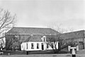
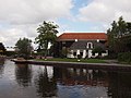
building in Skarsterlân, Netherlands  | |||||
| Upload media | |||||
| Instance of | |||||
|---|---|---|---|---|---|
| Location | Joure, Friesland, Netherlands | ||||
| Street address |
| ||||
| Located on street | |||||
| Heritage designation |
| ||||
 | |||||
|
This is a category about rijksmonument number 20845
|
| Address |
|
Media in category "Zijl 19, Joure"
The following 5 files are in this category, out of 5 total.
-
 De Helling Joure.JPG 4,032 × 3,024; 5.45 MB
-
 Overzicht - Joure - 20121121 - RCE.jpg 1,200 × 812; 201 KB
-
 Scheepswerf de Helling Joure.JPG 4,032 × 3,024; 4.97 MB
-
 Woonhuis - Joure - 20121119 - RCE.jpg 1,200 × 809; 263 KB
-
 Zijaanzicht - Joure - 20121120 - RCE.jpg 1,200 × 807; 239 KB


