Category:Zuid-Afrikahuis (Amsterdam)
Jump to navigation
Jump to search
| Object location | | View all coordinates using: OpenStreetMap |
|---|
information centre about South Africa  | |||||
| Upload media | |||||
| Instance of | |||||
|---|---|---|---|---|---|
| Location | Amsterdam, North Holland, Netherlands | ||||
| Street address |
| ||||
| Located on street | |||||
| official website | |||||
 | |||||
|
This is a category about rijksmonument number 2258
|
| Address |
|
Subcategories
This category has only the following subcategory.
Media in category "Zuid-Afrikahuis (Amsterdam)"
The following 19 files are in this category, out of 19 total.
-
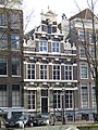
 Amsterdam - Keizersgracht 135-137-139.JPG 3,056 × 4,592; 4.83 MB
-
 Amsterdam - Keizersgracht 141.JPG 3,056 × 4,592; 4.47 MB
-
 Amsterdam, keizersgracht 141 - WLM 2011 - andrevanb (1).jpg 900 × 1,200; 448 KB
-
 Amsterdam, keizersgracht 141 - WLM 2011 - andrevanb (2).jpg 896 × 1,200; 459 KB
-
 Amsterdam, keizersgracht 141 - WLM 2011 - andrevanb.jpg 900 × 1,200; 463 KB
-
 Bibliotheek Suid-Afrikaanse Instituut Amsterdam.jpg 448 × 336; 43 KB
-
 Cornelis Gerardus Leenheer, Afb 010118000096.jpg 2,770 × 1,993; 921 KB
-
 JulianaZAH.jpg 3,648 × 5,472; 6.21 MB
-
 Keizersgracht 141.jpg 1,944 × 2,592; 777 KB
-
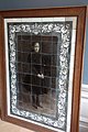
 KrugerSchwartze.jpg 2,549 × 3,295; 4.46 MB
-
 Overzicht - Amsterdam - 20018076 - RCE.jpg 946 × 1,200; 239 KB
-
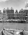 Overzicht - Amsterdam - 20018077 - RCE.jpg 955 × 1,200; 251 KB
-
 Overzicht gevel grachtenhuis - Amsterdam - 20322261 - RCE.jpg 946 × 1,200; 282 KB
-
 Staats Model School.jpg 1,753 × 2,480; 2.62 MB
-
 ZuidAfrikaHuis2018-1.jpg 5,472 × 3,648; 6.67 MB
-
 ZuidAfrikaHuis2018-2.jpg 5,472 × 3,648; 4.75 MB
-
 ZuidAfrikaHuis2018-3.jpg 3,648 × 5,472; 5.11 MB
-
 ZuidAfrikaHuis2018-4.jpg 3,648 × 5,472; 5.33 MB
-
 ZuidAfrikaHuis2018-5.jpg 5,472 × 3,648; 8.17 MB


.jpg)
.jpg)


