Category:Neuer jüdischer Friedhof (Niederursel)
Jump to navigation
Jump to search
| Object location | | View all coordinates using: OpenStreetMap |
|---|
Jewish cemetery in Germany | |||||
| Upload media | |||||
| Instance of | |||||
|---|---|---|---|---|---|
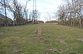
| Location | Niederursel, Frankfurt-Nord-West, Frankfurt, Darmstadt Government Region, Hesse, Germany | ||||
 | |||||
Media in category "Neuer jüdischer Friedhof (Niederursel)"
The following 3 files are in this category, out of 3 total.
-
 Neuer jüdischer Friedhof, 1, Niederursel, Frankfurt am Main.jpg 4,608 × 3,456; 6.69 MB
-
 Niederursel, Neuer jüdischer Friedhof, Gedenkstein.JPG 4,928 × 3,264; 7.85 MB
-
 Niederursel, Neuer jüdischer Friedhof.JPG 4,928 × 3,264; 8.57 MB


