Columbia River Gorge
Jump to navigation
Jump to search
canyon along the border of Oregon and Washington in the United States  | |||||
| Upload media | |||||
| Instance of | |||||
|---|---|---|---|---|---|
| Located in protected area | |||||
| Location |
| ||||
| Located in or next to body of water | |||||
| official website | |||||
 | |||||
-

-
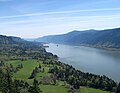
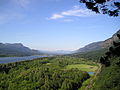 Looking east up the Columbia River Gorge from near Multnomah Falls
 -
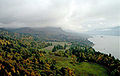
 Crown Point in the Columbia River Gorge, looking upstream from Chanticleer Point
 -
 seen from the southern edge of the Gifford Pinchot National Forest
 -
 The view east towards The Dalles from Dog Mountain
 -
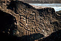 Native American petroglyphs in the Columbia River Gorge near The Dalles Dam
 -
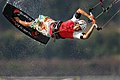 Kitesurfing on the Columbia River
 -
 View of Columbia River Gorge from Cape Horn Trail, looking east toward Beacon Rock
 -
 Columbia River Gorge, photographed from Crown Point.
 -
 Triple Falls
 -
 Oneonta Creek
 -
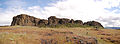 Horsethief Butte, near The Dalles
 -
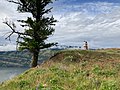 A couple overlooks the Columbia River Gorge from a viewpoint near Mosier, Oregon
 -
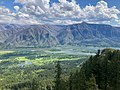 A view of the Oregon side of the Columbia River Gorge from Hamilton Mountain
 -
 Columbia River Gorge with Mount Adams and Mount Saint Helens barely visible, seen from the Devils Rest Trail


