| Name
|
Heritage list
|
Place
|
Street address
|
Coordinates
|
place_id
|
Image
|
| Central railway station (Q5062143)
|
listed on the Queensland Heritage Register
|
|
|
27°27′57″S 153°01′34″E / 27.4659°S 153.026°E / -27.4659; 153.026
|
600073
|

|
| Chapel of St Peter's Lutheran College (Q18754836)
|
listed on the Queensland Heritage Register
|
Indooroopilly
|
|
27°30′18″S 152°59′06″E / 27.5049°S 152.985°E / -27.5049; 152.985
|
602816
|

|
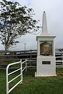
| Charleville War Memorial (Q23002790)
|
listed on the Queensland Heritage Register
|
|
|
26°24′11″S 146°14′27″E / 26.4031°S 146.2407°E / -26.4031; 146.2407
|
600758
|

|
| Charleville railway station, Queensland (Q15209165)
|
listed on the Queensland Heritage Register
|
|
|
26°24′22″S 146°14′39″E / 26.4062°S 146.2441°E / -26.4062; 146.2441
|
602368
|

|
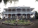
| Charlotte House (Q19872130)
|
listed on the Queensland Heritage Register
|
|
|
27°28′15″S 153°01′41″E / 27.4707°S 153.028°E / -27.4707; 153.028
|
600082
|

|
| Charters Towers Central State School (Q48805816)
|
listed on the Queensland Heritage Register
|
|
|
20°04′47″S 146°15′51″E / 20.0796°S 146.2642°E / -20.0796; 146.2642
|
602846
|

|
| Charters Towers Courthouse (Q5086888)
|
listed on the Queensland Heritage Register
|
|
|
20°04′40″S 146°15′40″E / 20.0779°S 146.261°E / -20.0779; 146.261
|
600403
|

|
| Charters Towers Masonic Lodge (Q23641152)
|
listed on the Queensland Heritage Register
|
|
|
20°04′33″S 146°15′38″E / 20.0758°S 146.2606°E / -20.0758; 146.2606
|
600411
|

|
| Charters Towers Police Station (Q24896000)
|
listed on the Queensland Heritage Register
|
|
|
20°04′34″S 146°15′34″E / 20.076°S 146.2594°E / -20.076; 146.2594
|
600401
|

|
| Charters Towers School of Mines (Q24890972)
|
listed on the Queensland Heritage Register
|
|
|
20°04′42″S 146°15′37″E / 20.0783°S 146.2604°E / -20.0783; 146.2604
|
600402
|

|
| Charters Towers Stock Exchange Arcade (Q5086892)
|
listed on the Queensland Heritage Register
|
|
|
20°04′33″S 146°15′25″E / 20.07593333°S 146.2569°E / -20.07593333; 146.2569
|
600406
|

|
| Charters Towers mine shafts (Q24883684)
|
listed on the Queensland Heritage Register
|
|
|
20°05′02″S 146°15′51″E / 20.084°S 146.2642°E / -20.084; 146.2642
|
602221
|

|
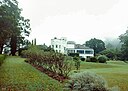
| Chateau Nous (Q19872234)
|
listed on the Queensland Heritage Register
|
|
|
27°25′58″S 153°03′47″E / 27.4327°S 153.063°E / -27.4327; 153.063
|
600047
|

|
| Chelmer Police College (Q18754766)
|
listed on the Queensland Heritage Register
|
|
|
27°30′41″S 152°58′12″E / 27.5113°S 152.97°E / -27.5113; 152.97
|
602340
|

|
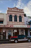
| Chemist, Childers (Q23641154)
|
listed on the Queensland Heritage Register
|
|
|
25°14′12″S 152°16′45″E / 25.2368°S 152.2791°E / -25.2368; 152.2791
|
600615
|

|
| Cherry Gully Tunnel (Q22329502)
|
listed on the Queensland Heritage Register
|
|
|
28°24′41″S 152°01′37″E / 28.4114°S 152.027°E / -28.4114; 152.027
|
601517
|

|
| Childers Ambulance Station (Q23641164)
|
listed on the Queensland Heritage Register
|
|
|
25°14′10″S 152°16′39″E / 25.2361°S 152.2775°E / -25.2361; 152.2775
|
600621
|

|
| Childers Bakery (Q23461422)
|
listed on the Queensland Heritage Register
|
|
|
25°14′13″S 152°16′42″E / 25.237°S 152.2782°E / -25.237; 152.2782
|
600626
|
|
| Childers Court House (Q23641165)
|
listed on the Queensland Heritage Register
|
|
|
25°14′10″S 152°16′40″E / 25.2361°S 152.2778°E / -25.2361; 152.2778
|
600620
|

|
| Childers Pharmaceutical Museum (Q23641166)
|
listed on the Queensland Heritage Register
|
|
|
25°14′13″S 152°16′41″E / 25.237°S 152.2781°E / -25.237; 152.2781
|
600628
|

|
| Childers Post Office (Q23641167)
|
listed on the Queensland Heritage Register
|
|
|
25°14′10″S 152°16′42″E / 25.2361°S 152.2783°E / -25.2361; 152.2783
|
600619
|

|
| Childers RSL Club (Q23641168)
|
listed on the Queensland Heritage Register
|
|
|
25°14′09″S 152°16′46″E / 25.2359°S 152.2794°E / -25.2359; 152.2794
|
600613
|

|
| Chillagoe smelters (Q5099015)
|
listed on the Queensland Heritage Register
|
|
|
17°08′40″S 144°31′11″E / 17.1445°S 144.5198°E / -17.1445; 144.5198
|
600675
|

|
| Chinatown, Atherton (Q24884292)
|
listed on the Queensland Heritage Register
|
|
|
17°16′42″S 145°28′20″E / 17.2783°S 145.4722°E / -17.2783; 145.4722
|
600011
|

|
| Chinchilla Digger Statue (Q23018868)
|
listed on the Queensland Heritage Register
|
|
|
26°44′32″S 150°37′23″E / 26.7421°S 150.623°E / -26.7421; 150.623
|
601269
|

|
| Chinese Temple and Settlement Site, Croydon (Q25231280)
|
listed on the Queensland Heritage Register
|
|
|
18°11′54″S 142°14′50″E / 18.1984°S 142.2472°E / -18.1984; 142.2472
|
602079
|

|
| Christ Church Anglican Church, St Lawrence (Q23641172)
|
listed on the Queensland Heritage Register
|
|
|
22°20′47″S 149°32′19″E / 22.3464°S 149.5385°E / -22.3464; 149.5385
|
601661
|

|
| Christ Church, Childers (Q16890345)
|
listed on the Queensland Heritage Register
|
|
|
25°14′15″S 152°16′37″E / 25.2376°S 152.277°E / -25.2376; 152.277
|
601994
|

|
| Christ Church, Milton (Q16890344)
|
listed on the Queensland Heritage Register
|
|
|
27°27′58″S 153°00′36″E / 27.466°S 153.01°E / -27.466; 153.01
|
600252
|

|
| Christ Church, Tingalpa (Q19872267)
|
listed on the Queensland Heritage Register
|
|
|
27°28′23″S 153°06′43″E / 27.473°S 153.112°E / -27.473; 153.112
|
601799
|

|
| Church House, Brisbane (Q19817739)
|
listed on the Queensland Heritage Register
|
|
|
27°27′49″S 153°01′48″E / 27.4635°S 153.03°E / -27.4635; 153.03
|
600077
|

|
| Church of Christ, Charters Towers (Q24895303)
|
listed on the Queensland Heritage Register
|
|
|
20°04′25″S 146°15′48″E / 20.0737°S 146.2634°E / -20.0737; 146.2634
|
601245
|

|
| Church of Saint Ignatius Loyola (Q19817740)
|
listed on the Queensland Heritage Register
|
|
|
27°29′09″S 152°59′13″E / 27.4859°S 152.987°E / -27.4859; 152.987
|
602532
|

|
| Cintra House (Q19817741)
|
listed on the Queensland Heritage Register
|
|
|
27°26′48″S 153°02′24″E / 27.4466°S 153.04°E / -27.4466; 153.04
|
600054
|

|
| City Botanic Gardens (Q917681)
|
listed on the Queensland Heritage Register
|
|
|
27°28′29″S 153°01′48″E / 27.4747°S 153.03°E / -27.4747; 153.03
|
600067
|

|
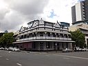
| City View Hotel (Q20085686)
|
listed on the Queensland Heritage Register
|
|
|
27°36′56″S 152°45′04″E / 27.6155°S 152.751°E / -27.6155; 152.751
|
600557
|

|
| Civic Club, Charters Towers (Q24895118)
|
listed on the Queensland Heritage Register
|
|
|
20°04′34″S 146°15′45″E / 20.076°S 146.2624°E / -20.076; 146.2624
|
600398
|

|
| Clancholla (Q23641184)
|
listed on the Queensland Heritage Register
|
|
|
23°23′53″S 150°29′57″E / 23.3981°S 150.4991°E / -23.3981; 150.4991
|
601592
|

|
| Claremont, Ipswich (Q23641187)
|
listed on the Queensland Heritage Register
|
|
|
27°36′49″S 152°45′58″E / 27.6137°S 152.7661°E / -27.6137; 152.7661
|
600589
|

|
| Clayton's Apothecaries' Hall (Q23641193)
|
listed on the Queensland Heritage Register
|
|
|
19°15′27″S 146°49′08″E / 19.2576°S 146.819°E / -19.2576; 146.819
|
600902
|
|
| Clermont Cemetery (Q22919823)
|
listed on the Queensland Heritage Register
|
|
|
22°48′37″S 147°38′48″E / 22.8103°S 147.6467°E / -22.8103; 147.6467
|
602756
|

|
| Cleveland Hotel (Q19872320)
|
listed on the Queensland Heritage Register
|
|
|
27°31′20″S 153°17′12″E / 27.522179°S 153.28662°E / -27.522179; 153.28662
|
601130
|
|
| Cleveland Pioneer Cemetery (Q19872323)
|
listed on the Queensland Heritage Register
|
|
|
27°31′41″S 153°15′25″E / 27.5281°S 153.257°E / -27.5281; 153.257
|
645608
|

|
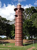
| Cleveland Point Light (Q5132205)
|
listed on the Queensland Heritage Register
|
|
|
27°30′37″S 153°17′21″E / 27.51017222°S 153.28907778°E / -27.51017222; 153.28907778
|
600772
|

|
| Clewett's Building (Q23641195)
|
listed on the Queensland Heritage Register
|
|
|
23°22′51″S 150°30′59″E / 23.3808°S 150.5163°E / -23.3808; 150.5163
|
600814
|

|
| Clifford House, Toowoomba (Q18347949)
|
listed on the Queensland Heritage Register
|
|
|
27°33′31″S 151°56′49″E / 27.5587°S 151.947°E / -27.5587; 151.947
|
600857
|
|
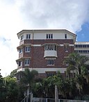
| Cliffside Apartments (Q19872330)
|
listed on the Queensland Heritage Register
|
|
|
27°28′57″S 153°01′55″E / 27.4824°S 153.032°E / -27.4824; 153.032
|
601650
|
|
| Cliveden Mansions (Q19872335)
|
listed on the Queensland Heritage Register
|
|
|
27°27′37″S 153°01′08″E / 27.4604°S 153.019°E / -27.4604; 153.019
|
602186
|

|
| Cloncurry Courthouse (Q5134978)
|
listed on the Queensland Heritage Register
|
|
|
20°42′17″S 140°30′22″E / 20.7047°S 140.506°E / -20.7047; 140.506
|
600415
|

|
| Cloncurry Post Office (Q28183459)
|
listed on the Queensland Heritage Register
|
|
|
20°42′19″S 140°30′21″E / 20.7054°S 140.5058°E / -20.7054; 140.5058
|
600416
|

|
| Cluden Racecourse (Q23641197)
|
listed on the Queensland Heritage Register
|
|
|
19°19′19″S 146°49′15″E / 19.322°S 146.8208°E / -19.322; 146.8208
|
600924
|

|
| Coen Carrier Station (Q24997962)
|
listed on the Queensland Heritage Register
|
|
|
13°56′24″S 143°11′56″E / 13.9399°S 143.1989°E / -13.9399; 143.1989
|
601485
|

|
| Colinton War Memorial (Q48990182)
|
listed on the Queensland Heritage Register
|
|
|
26°55′49″S 152°19′23″E / 26.9304°S 152.323°E / -26.9304; 152.323
|
650029
|

|
| Collingwood Water Race (Q24998011)
|
listed on the Queensland Heritage Register
|
|
|
15°47′20″S 145°15′22″E / 15.789°S 145.256°E / -15.789; 145.256
|
602257
|
|
| Collins Place, South Brisbane (Q19872403)
|
listed on the Queensland Heritage Register
|
|
|
27°28′54″S 153°01′23″E / 27.4817°S 153.023°E / -27.4817; 153.023
|
600296
|

|
| Collinsville Cemetery, Queensland (Q22919825)
|
listed on the Queensland Heritage Register
|
|
|
20°34′07″S 147°50′13″E / 20.5686°S 147.8369°E / -20.5686; 147.8369
|
602730
|

|
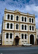
| Colonial Mutual Chambers (Q16890505)
|
listed on the Queensland Heritage Register
|
|
|
27°28′13″S 153°01′26″E / 27.4704°S 153.024°E / -27.4704; 153.024
|
600160
|

|
| Colonsay Farm (Q23641209)
|
listed on the Queensland Heritage Register
|
|
|
25°18′48″S 152°50′52″E / 25.3132°S 152.8477°E / -25.3132; 152.8477
|
602771
|

|
| Colthup's House (Q23641210)
|
listed on the Queensland Heritage Register
|
|
|
27°36′56″S 152°45′12″E / 27.6156°S 152.7534°E / -27.6156; 152.7534
|
600582
|

|
| Combined Services Detailed Interrogation Centre, Brisbane (Q55608017)
|
listed on the Queensland Heritage Register
|
|
|
27°30′16″S 152°58′32″E / 27.504521°S 152.97545°E / -27.504521; 152.97545
|
650030
|
|
| Comino's Arcade (Q23641213)
|
listed on the Queensland Heritage Register
|
|
|
27°13′38″S 153°06′53″E / 27.2271°S 153.1147°E / -27.2271; 153.1147
|
602692
|

|
| Commercial Bank of Australia Building, Townsville (Q23641214)
|
listed on the Queensland Heritage Register
|
|
|
19°15′27″S 146°49′09″E / 19.2575°S 146.8193°E / -19.2575; 146.8193
|
600900
|

|
| Commercial Bank, Bundaberg (Q23641215)
|
listed on the Queensland Heritage Register
|
|
|
24°51′59″S 152°20′48″E / 24.8663°S 152.3468°E / -24.8663; 152.3468
|
600363
|

|
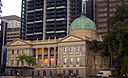
| Commissariat Store, Brisbane (Q5152612)
|
listed on the Queensland Heritage Register
|
|
|
27°28′24″S 153°01′27″E / 27.47327°S 153.02425°E / -27.47327; 153.02425
|
600176
|

|
| Commissioner Bidwill's Grave (Q22919826)
|
listed on the Queensland Heritage Register
|
|
|
25°33′47″S 152°42′40″E / 25.5631°S 152.7111°E / -25.5631; 152.7111
|
601822
|

|
| Commonwealth Acetate of Lime Factory (Q19872436)
|
listed on the Queensland Heritage Register
|
|
|
27°27′05″S 153°05′20″E / 27.4514°S 153.089°E / -27.4514; 153.089
|
602465
|

|
| Commonwealth Bank Building, Gladstone (Q23641712)
|
listed on the Queensland Heritage Register
|
|
|
23°50′35″S 151°15′22″E / 23.8431°S 151.2561°E / -23.8431; 151.2561
|
601338
|

|
| Commonwealth Bank Building, Mackay (Q23641713)
|
listed on the Queensland Heritage Register
|
|
|
21°08′30″S 149°11′15″E / 21.1417°S 149.1876°E / -21.1417; 149.1876
|
600671
|

|
| Commonwealth Bank Building, Mount Morgan (Q23641715)
|
listed on the Queensland Heritage Register
|
|
|
23°38′45″S 150°23′15″E / 23.6457°S 150.3876°E / -23.6457; 150.3876
|
600746
|

|
| Commonwealth Bank Building, Townsville (Q23641716)
|
listed on the Queensland Heritage Register
|
|
|
19°15′32″S 146°49′05″E / 19.2588°S 146.8181°E / -19.2588; 146.8181
|
602471
|

|
| Commonwealth Government Offices, Brisbane (Q19872441)
|
listed on the Queensland Heritage Register
|
|
|
27°27′59″S 153°01′37″E / 27.4664°S 153.027°E / -27.4664; 153.027
|
600064
|

|
| Commonwealth Offices, Townsville (Q23641717)
|
listed on the Queensland Heritage Register
|
|
|
19°15′30″S 146°49′01″E / 19.2583°S 146.817°E / -19.2583; 146.817
|
600932
|
|
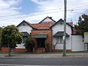
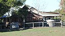
| Community Hall (Q25631120)
|
listed on the Queensland Heritage Register
|
Camooweal
|
|
19°55′16″S 138°07′14″E / 19.9212°S 138.1205°E / -19.9212; 138.1205
|
600740
|

|
| Como, Yeronga (Q19817742)
|
listed on the Queensland Heritage Register
|
|
|
27°30′57″S 153°00′43″E / 27.5157°S 153.012°E / -27.5157; 153.012
|
601474
|

|
| Concordia College Administration Centre (Q18348664)
|
listed on the Queensland Heritage Register
|
|
|
27°34′20″S 151°55′48″E / 27.5722°S 151.93°E / -27.5722; 151.93
|
600869
|

|
| Conon, Lutwyche (Q19872465)
|
listed on the Queensland Heritage Register
|
|
|
27°25′28″S 153°02′10″E / 27.4245°S 153.036°E / -27.4245; 153.036
|
600346
|
|
| Conondale Timbers Sawmill (Q23641721)
|
listed on the Queensland Heritage Register
|
|
|
26°44′54″S 152°44′03″E / 26.7483°S 152.7341°E / -26.7483; 152.7341
|
602689
|

|
| Content Mine (Q24998045)
|
listed on the Queensland Heritage Register
|
|
|
18°10′18″S 142°13′12″E / 18.1718°S 142.2201°E / -18.1718; 142.2201
|
602243
|

|
| Coochin Coochin Homestead (Q19872478)
|
listed on the Queensland Heritage Register
|
|
|
28°06′24″S 152°37′48″E / 28.1066°S 152.63°E / -28.1066; 152.63
|
600034
|

|
| Cook Shire Council Chambers (Q24998020)
|
listed on the Queensland Heritage Register
|
|
|
15°27′57″S 145°14′57″E / 15.4659°S 145.2493°E / -15.4659; 145.2493
|
601535
|

|
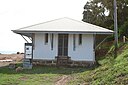
| Cook Shire Hall (Q21017056)
|
listed on the Queensland Heritage Register
|
|
|
15°28′14″S 145°15′01″E / 15.4706°S 145.2502°E / -15.4706; 145.2502
|
601704
|

|
| Cook Terrace (Q19872481)
|
listed on the Queensland Heritage Register
|
|
|
27°28′21″S 153°00′22″E / 27.4724°S 153.006°E / -27.4724; 153.006
|
600250
|

|
| Cook's Landing Place, Town of Seventeen Seventy (Q22000801)
|
listed on the Queensland Heritage Register
|
|
|
24°09′40″S 151°53′11″E / 24.161°S 151.8865°E / -24.161; 151.8865
|
601614
|
|
| Cooks Monument and Reserve (Q24994008)
|
listed on the Queensland Heritage Register
|
|
|
15°27′48″S 145°15′00″E / 15.4634°S 145.2499°E / -15.4634; 145.2499
|
601044
|

|
| Cooktown Cemetery (Q24998019)
|
listed on the Queensland Heritage Register
|
|
|
15°28′33″S 145°14′28″E / 15.4759°S 145.2411°E / -15.4759; 145.2411
|
601147
|

|
| Cooktown Powder Magazine (Q24998022)
|
listed on the Queensland Heritage Register
|
|
|
15°27′27″S 145°15′14″E / 15.4576°S 145.2539°E / -15.4576; 145.2539
|
600425
|
|
| Coolgarra Battery (Q24887426)
|
listed on the Queensland Heritage Register
|
|
|
17°34′22″S 145°12′23″E / 17.5729°S 145.2065°E / -17.5729; 145.2065
|
601791
|

|
| Cooloola Tramway (Q22329504)
|
listed on the Queensland Heritage Register
|
|
|
25°59′37″S 153°04′35″E / 25.9936°S 153.0763°E / -25.9936; 153.0763
|
602819
|

|
| Coorooman (Q19872526)
|
listed on the Queensland Heritage Register
|
|
|
27°28′59″S 153°01′19″E / 27.4831°S 153.022°E / -27.4831; 153.022
|
600224
|

|
| Cooroora Masonic Temple (Q23641724)
|
listed on the Queensland Heritage Register
|
|
|
26°22′02″S 152°51′25″E / 26.3671°S 152.8569°E / -26.3671; 152.8569
|
602423
|

|
| Cooroy Lower Mill Site Kiln (Q23641725)
|
listed on the Queensland Heritage Register
|
|
|
26°24′51″S 152°54′35″E / 26.4142°S 152.9096°E / -26.4142; 152.9096
|
602688
|

|
| Cooroy railway station (Q5168051)
|
listed on the Queensland Heritage Register
|
|
|
26°25′03″S 152°54′40″E / 26.4176°S 152.9112°E / -26.4176; 152.9112
|
602381
|

|
| Coorparoo Fire Station (Q18754821)
|
listed on the Queensland Heritage Register
|
|
|
27°29′48″S 153°03′36″E / 27.4966°S 153.06°E / -27.4966; 153.06
|
600569
|

|
| Coorparoo School of Arts and RSL Memorial Hall (Q19872528)
|
listed on the Queensland Heritage Register
|
|
|
27°29′45″S 153°03′36″E / 27.4957°S 153.06°E / -27.4957; 153.06
|
602054
|
|
| Coorparoo State School (Q48815827)
|
listed on the Queensland Heritage Register
|
|
|
27°29′42″S 153°03′38″E / 27.4949°S 153.0605°E / -27.4949; 153.0605
|
650047
|

|
| Coorparoo Substation No. 210 (Q19872532)
|
listed on the Queensland Heritage Register
|
|
|
27°29′54″S 153°03′04″E / 27.4982°S 153.051°E / -27.4982; 153.051
|
602495
|

|
| Cooyar War Memorial (Q18348906)
|
listed on the Queensland Heritage Register
|
|
|
26°58′58″S 151°49′52″E / 26.9828°S 151.831°E / -26.9828; 151.831
|
600825
|

|
| Corbett and Son Store (Q19817743)
|
listed on the Queensland Heritage Register
|
|
|
27°27′36″S 153°02′13″E / 27.4599°S 153.037°E / -27.4599; 153.037
|
601022
|

|
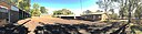
| Corduroy Road Remains (Q18619731)
|
listed on the Queensland Heritage Register
|
|
|
27°38′48″S 152°22′37″E / 27.6466°S 152.377°E / -27.6466; 152.377
|
600657
|

|
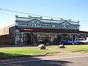
| Corfield & Fitzmaurice Store (Q28184357)
|
listed on the Queensland Heritage Register
|
|
|
22°23′22″S 143°02′18″E / 22.3895°S 143.0384°E / -22.3895; 143.0384
|
600965
|
|
| Coronation Building (Q23641726)
|
listed on the Queensland Heritage Register
|
|
|
25°14′12″S 152°16′39″E / 25.2368°S 152.2776°E / -25.2368; 152.2776
|
600629
|

|
| Coronation Drive retaining wall (Q19872544)
|
listed on the Queensland Heritage Register
|
|
|
27°28′06″S 153°00′47″E / 27.4682°S 153.013°E / -27.4682; 153.013
|
600134
|

|
| Coronation Hotel (Q19817744)
|
listed on the Queensland Heritage Register
|
|
|
27°28′16″S 153°00′54″E / 27.4712°S 153.015°E / -27.4712; 153.015
|
600298
|
|
| Coronation Lamp War Memorial (Q23018876)
|
listed on the Queensland Heritage Register
|
|
|
23°38′45″S 150°23′05″E / 23.6458°S 150.3846°E / -23.6458; 150.3846
|
600750
|

|
| Corpus Christi Church (Q19864653)
|
listed on the Queensland Heritage Register
|
|
|
27°24′14″S 153°03′25″E / 27.404°S 153.057°E / -27.404; 153.057
|
601460
|

|
| Cotswold Cottage, Maroon (Q19872558)
|
listed on the Queensland Heritage Register
|
|
|
28°10′56″S 152°44′46″E / 28.1823°S 152.746°E / -28.1823; 152.746
|
600037
|

|
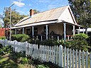
| Cottage (Q18349064)
|
listed on the Queensland Heritage Register
|
|
|
27°34′22″S 151°56′35″E / 27.5728°S 151.943°E / -27.5728; 151.943
|
601313
|

|
| Cotton Tree Caravan Park (Q23641729)
|
listed on the Queensland Heritage Register
|
|
|
26°39′08″S 153°06′02″E / 26.6523°S 153.1006°E / -26.6523; 153.1006
|
602707
|

|
| Craigellachie, Windsor (Q19872600)
|
listed on the Queensland Heritage Register
|
|
|
27°25′40″S 153°02′02″E / 27.4277°S 153.034°E / -27.4277; 153.034
|
600348
|

|
| Craigerne (Q18589031)
|
listed on the Queensland Heritage Register
|
|
|
27°26′55″S 153°00′22″E / 27.4487°S 153.006°E / -27.4487; 153.006
|
600286
|

|
| Craigston (Q19817745)
|
listed on the Queensland Heritage Register
|
|
|
27°27′55″S 153°01′23″E / 27.4653°S 153.023°E / -27.4653; 153.023
|
600165
|

|
| Crawford and Co Building (Q23641733)
|
listed on the Queensland Heritage Register
|
|
|
26°11′21″S 152°39′33″E / 26.1891°S 152.6591°E / -26.1891; 152.6591
|
602780
|

|
| Cremorne, Hamilton (Q19872610)
|
listed on the Queensland Heritage Register
|
|
|
27°26′20″S 153°03′32″E / 27.439°S 153.059°E / -27.439; 153.059
|
600218
|
|
| Cressbrook Cemetery (Q24885527)
|
listed on the Queensland Heritage Register
|
|
|
17°29′59″S 145°27′00″E / 17.4997°S 145.4501°E / -17.4997; 145.4501
|
601900
|

|
| Cressbrook Homestead (Q23641735)
|
listed on the Queensland Heritage Register
|
|
|
27°03′28″S 152°24′17″E / 27.0578°S 152.4047°E / -27.0578; 152.4047
|
600503
|

|
| Criterion Hotel, Maryborough (Q23641736)
|
listed on the Queensland Heritage Register
|
|
|
25°32′21″S 152°42′21″E / 25.5392°S 152.7057°E / -25.5392; 152.7057
|
600719
|

|
| Criterion Hotel, Rockhampton (Q23641738)
|
listed on the Queensland Heritage Register
|
|
|
23°22′35″S 150°30′48″E / 23.3763°S 150.5132°E / -23.3763; 150.5132
|
600800
|

|
| Criterion Hotel, Warwick (Q20085689)
|
listed on the Queensland Heritage Register
|
|
|
28°12′56″S 152°01′59″E / 28.2155°S 152.033°E / -28.2155; 152.033
|
600962
|

|
| Crohamhurst Observatory (Q23641741)
|
listed on the Queensland Heritage Register
|
|
|
26°48′35″S 152°52′11″E / 26.8098°S 152.8697°E / -26.8098; 152.8697
|
602682
|

|
| Cross Terrace (Q19872632)
|
listed on the Queensland Heritage Register
|
|
|
27°27′31″S 153°00′29″E / 27.4587°S 153.008°E / -27.4587; 153.008
|
600285
|
|
| Crows Nest Post Office (Q18349376)
|
listed on the Queensland Heritage Register
|
|
|
27°15′44″S 152°03′22″E / 27.2622°S 152.056°E / -27.2622; 152.056
|
602403
|

|
| Croydon Cemetery, Queensland (Q25231273)
|
listed on the Queensland Heritage Register
|
|
|
18°13′21″S 142°14′38″E / 18.2225°S 142.244°E / -18.2225; 142.244
|
602376
|

|
| Croydon Court House (Q25248348)
|
listed on the Queensland Heritage Register
|
|
|
18°12′12″S 142°14′38″E / 18.2033°S 142.2439°E / -18.2033; 142.2439
|
600437
|

|
| Croydon Hospital Ward (Q25231213)
|
listed on the Queensland Heritage Register
|
|
|
18°12′10″S 142°14′33″E / 18.2027°S 142.2424°E / -18.2027; 142.2424
|
600438
|

|
| Croydon Police Station (Q25248360)
|
listed on the Queensland Heritage Register
|
|
|
18°12′12″S 142°14′39″E / 18.2032°S 142.2443°E / -18.2032; 142.2443
|
601153
|

|
| Croydon Shire Hall (Q25248362)
|
listed on the Queensland Heritage Register
|
|
|
18°12′12″S 142°14′37″E / 18.2033°S 142.2437°E / -18.2033; 142.2437
|
601653
|

|
| Croydon railway station, Queensland (Q25248364)
|
listed on the Queensland Heritage Register
|
|
|
18°12′09″S 142°14′21″E / 18.2026°S 142.2393°E / -18.2026; 142.2393
|
600440
|

|
| Cumbooquepa (Q28183347)
|
listed on the Queensland Heritage Register
|
|
|
27°29′00″S 153°01′28″E / 27.4832°S 153.0244°E / -27.4832; 153.0244
|
600305
|

|
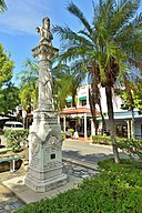
| Cunnamulla War Memorial Fountain (Q23002807)
|
listed on the Queensland Heritage Register
|
|
|
28°04′04″S 145°41′02″E / 28.0679°S 145.6838°E / -28.0679; 145.6838
|
600760
|

|
| Currajong (Q23641745)
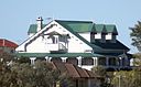
|
listed on the Queensland Heritage Register
|
West End
|
|
19°16′15″S 146°48′09″E / 19.2707°S 146.8024°E / -19.2707; 146.8024
|
600884
|
|
| Currumbin Wildlife Sanctuary (Q5195193)
|
listed on the Queensland Heritage Register
|
|
|
28°08′09″S 153°29′17″E / 28.1359°S 153.488°E / -28.1359; 153.488
|
602720
|

|
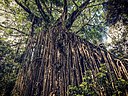
| Curtain Fig Tree (Q3007781)
|
listed on the Queensland Heritage Register
|
Yungaburra
|
|
17°17′09″S 145°34′26″E / 17.2858°S 145.574°E / -17.2858; 145.574
|
602734
|
|
| Customs House Hotel, Maryborough (Q14935399)
|
listed on the Queensland Heritage Register
|
|
|
25°32′19″S 152°42′19″E / 25.5386°S 152.7052°E / -25.5386; 152.7052
|
600715
|

|
| Customs House Museum (Q28184285)
|
listed on the Queensland Heritage Register
|
|
|
28°32′56″S 150°18′24″E / 28.5489°S 150.3068°E / -28.5489; 150.3068
|
600530
|
|
| Customs House, Brisbane (Q1146279)
|
listed on the Queensland Heritage Register
|
|
|
27°27′56″S 153°01′52″E / 27.4655°S 153.031°E / -27.4655; 153.031
|
600156
|
|
| Customs House, Maryborough (Q23641746)
|
listed on the Queensland Heritage Register
|
|
|
25°32′18″S 152°42′20″E / 25.5384°S 152.7055°E / -25.5384; 152.7055
|
600709
|

|
| Customs House, Rockhampton (Q23641747)
|
listed on the Queensland Heritage Register
|
|
|
23°22′42″S 150°30′53″E / 23.3783°S 150.5146°E / -23.3783; 150.5146
|
600817
|

|
| Dalby Fire Station (Q28183955)
|
listed on the Queensland Heritage Register
|
|
|
27°10′47″S 151°16′00″E / 27.1798°S 151.2667°E / -27.1798; 151.2667
|
602754
|

|
| Dalby Olympic Swimming Pool (Q28183950)
|
listed on the Queensland Heritage Register
|
|
|
27°11′03″S 151°16′01″E / 27.1843°S 151.267°E / -27.1843; 151.267
|
602564
|

|
| Dalby State High School (Q48817968)
|
listed on the Queensland Heritage Register
|
|
|
27°10′38″S 151°15′32″E / 27.1773°S 151.259°E / -27.1773; 151.259
|
650036
|

|
| Dalby Town Council Chambers and Offices (Q28183971)
|
listed on the Queensland Heritage Register
|
|
|
27°11′00″S 151°15′52″E / 27.1832°S 151.2644°E / -27.1832; 151.2644
|
601018
|

|
| Dalby War Memorial and Gates (Q23002813)
|
listed on the Queensland Heritage Register
|
|
|
27°11′02″S 151°16′04″E / 27.1838°S 151.2677°E / -27.1838; 151.2677
|
600441
|

|
| Dalgety Offices, Townsville (Q23641757)
|
listed on the Queensland Heritage Register
|
|
|
19°15′26″S 146°49′01″E / 19.2573°S 146.817°E / -19.2573; 146.817
|
602520
|

|
| Dalveen Tunnel (Q22329507)
|
listed on the Queensland Heritage Register
|
|
|
28°29′20″S 151°58′49″E / 28.4889°S 151.9803°E / -28.4889; 151.9803
|
601519
|

|
| Darr River Downs (Q28184226)
|
listed on the Queensland Heritage Register
|
|
|
22°53′47″S 143°58′56″E / 22.8964°S 143.9821°E / -22.8964; 143.9821
|
600666
|

|
| David Fleay Wildlife Park (Q4355489)
|
listed on the Queensland Heritage Register
|
|
|
28°06′28″S 153°26′38″E / 28.1078°S 153.444°E / -28.1078; 153.444
28°06′25″S 153°26′39″E / 28.10701°S 153.44412°E / -28.10701; 153.44412
|
601389
|

|
| Dawson Valley Colliery (Q28184100)
|
listed on the Queensland Heritage Register
|
|
|
24°10′33″S 149°48′40″E / 24.1759°S 149.811°E / -24.1759; 149.811
|
602723
|

|
| Day Dawn mine remains, Charters Towers (Q24883652)
|
listed on the Queensland Heritage Register
|
|
|
20°05′01″S 146°15′30″E / 20.0835°S 146.2583°E / -20.0835; 146.2583
|
602200
|

|
| Deception Bay Sea Baths (Q23641773)
|
listed on the Queensland Heritage Register
|
|
|
27°10′49″S 153°01′49″E / 27.1804°S 153.0302°E / -27.1804; 153.0302
|
602509
|

|
| Deebing Creek Mission (Q23641774)
|
listed on the Queensland Heritage Register
|
|
|
27°41′03″S 152°45′51″E / 27.6842°S 152.7642°E / -27.6842; 152.7642
|
602251
|

|
| Deep Creek Railway Bridge (Q28183990)
|
listed on the Queensland Heritage Register
|
|
|
25°27′58″S 151°56′34″E / 25.46608597°S 151.94289231°E / -25.46608597; 151.94289231
|
600031
|

|
| Defiance Flour Mill (Q18350969)
|
listed on the Queensland Heritage Register
|
|
|
27°33′21″S 151°57′14″E / 27.5558°S 151.954°E / -27.5558; 151.954
|
601306
|

|
| Department of Primary Industries Building (Q19872851)
|
listed on the Queensland Heritage Register
|
|
|
27°28′25″S 153°01′30″E / 27.4736°S 153.025°E / -27.4736; 153.025
|
601093
|

|
| Diamantina Health Care Museum (Q19872867)
|
listed on the Queensland Heritage Register
|
|
|
27°30′02″S 153°01′59″E / 27.5005°S 153.033°E / -27.5005; 153.033
|
602560
|

|
| Dickabram Bridge (Q5273599)
|
listed on the Queensland Heritage Register
|
Miva
|
|
25°57′14″S 152°29′43″E / 25.954°S 152.4954°E / -25.954; 152.4954
|
600836
|

|
| Dittmer's Store (Q23641790)
|
listed on the Queensland Heritage Register
|
|
|
25°14′13″S 152°16′41″E / 25.237°S 152.278°E / -25.237; 152.278
|
600630
|

|
| Doggetts Cottage (Q19872928)
|
listed on the Queensland Heritage Register
|
|
|
27°27′37″S 153°02′20″E / 27.4604°S 153.039°E / -27.4604; 153.039
|
600258
|

|
| Dornoch Terrace Bridge (Q18618951)
|
listed on the Queensland Heritage Register
|
|
|
27°29′12″S 153°00′40″E / 27.4867°S 153.011°E / -27.4867; 153.011
|
602460
|

|
| Double Island Point Light (Q5299823)
|
listed on the Queensland Heritage Register
|
|
|
25°55′56″S 153°11′20″E / 25.93212222°S 153.18896111°E / -25.93212222; 153.18896111
|
601722
|

|
| Dr EA Koch Memorial (Q24190592)
|
listed on the Queensland Heritage Register
|
|
|
16°55′23″S 145°46′43″E / 16.923°S 145.7787°E / -16.923; 145.7787
|
601681
|

|
| Dr Ludwig Becker's Grave (Q26821364)
|
listed on the Queensland Heritage Register
|
|
|
28°19′16″S 143°07′27″E / 28.321°S 143.1241°E / -28.321; 143.1241
|
601359
|
|
| Drayton and Toowoomba Cemetery (Q18330926)
|
listed on the Queensland Heritage Register
|
|
|
27°34′36″S 151°55′08″E / 27.5766°S 151.919°E / -27.5766; 151.919
|
602718
|
|
| Drew Residence (Q19873001)
|
listed on the Queensland Heritage Register
|
|
|
27°19′48″S 153°04′30″E / 27.33°S 153.075°E / -27.33; 153.075
|
602024
|
|
| Drill Shed, Fortitude Valley (Q19873004)
|
listed on the Queensland Heritage Register
|
|
|
27°27′11″S 153°01′48″E / 27.4531°S 153.03°E / -27.4531; 153.03
|
602797
|

|
| Drystone Wall, Melton Hill (Q23641801)
|
listed on the Queensland Heritage Register
|
|
|
19°15′20″S 146°49′15″E / 19.2555°S 146.8207°E / -19.2555; 146.8207
|
600885
|

|
| Duaringa State School (Q83302918)
|
listed on the Queensland Heritage Register
|
|
|
|
650097
|
|
| Dularcha Railway Tunnel (Q22329508)
|
listed on the Queensland Heritage Register
|
|
|
26°46′49″S 152°57′41″E / 26.7804°S 152.9615°E / -26.7804; 152.9615
|
601522
|

|
| Dunaverty, Albion (Q19873023)
|
listed on the Queensland Heritage Register
|
|
|
27°25′42″S 153°02′31″E / 27.4282°S 153.042°E / -27.4282; 153.042
|
600045
|

|
| Dunethin Rock (Q23641805)
|
listed on the Queensland Heritage Register
|
|
|
26°34′38″S 153°00′44″E / 26.5771°S 153.0121°E / -26.5771; 153.0121
|
602695
|

|
| Dunwich Cemetery (Q19872817)
|
listed on the Queensland Heritage Register
|
|
|
27°29′40″S 153°24′14″E / 27.4945°S 153.404°E / -27.4945; 153.404
|
600773
|

|
| Dunwich Convict Causeway (Q19873038)
|
listed on the Queensland Heritage Register
|
|
|
22°30′S 150°45′E / 22.5°S 150.75°E / -22.5; 150.75
|
601021
|

|
| Dunwich Public Reserve (Q19873039)
|
listed on the Queensland Heritage Register
|
|
|
27°30′04″S 153°24′07″E / 27.501°S 153.402°E / -27.501; 153.402
|
602139
|

|
| Dutton Park State School (Q83303189)
|
listed on the Queensland Heritage Register
|
|
|
27°29′36″S 153°01′42″E / 27.4934°S 153.0282°E / -27.4934; 153.0282
|
650087
|
|
| Dux Hut (Q19873045)
|
listed on the Queensland Heritage Register
|
|
|
27°47′48″S 153°25′52″E / 27.7968°S 153.431°E / -27.7968; 153.431
|
602012
|

|
| ED Miles Mining Exchange (Q24895366)
|
listed on the Queensland Heritage Register
|
|
|
20°04′29″S 146°15′28″E / 20.0748°S 146.2578°E / -20.0748; 146.2578
|
602801
|

|
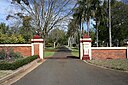
| Eagle Farm Racecourse (Q5325079)
|
listed on the Queensland Heritage Register
|
|
|
27°25′40″S 153°04′01″E / 27.4277°S 153.067°E / -27.4277; 153.067
|
602195
|

|
| Eagle Farm Racecourse and Ascot Railway Station (Q28184451)
|
listed on the Queensland Heritage Register
|
|
|
27°25′38″S 153°04′03″E / 27.4271°S 153.0675°E / -27.4271; 153.0675
|
602195
|
|
| Eagle Farm Women's Prison and Factory Site (Q17003446)
|
listed on the Queensland Heritage Register
|
|
|
27°25′49″S 153°04′59″E / 27.4303°S 153.083°E / -27.4303; 153.083
|
600186
|

|
| Eagle Street Fig Trees (Q19873057)
|
listed on the Queensland Heritage Register
|
|
|
27°28′04″S 153°01′48″E / 27.4677°S 153.03°E / -27.4677; 153.03
|
602440
|

|
| Early Granite Kerbing and Channelling, Cooktown (Q24998031)
|
listed on the Queensland Heritage Register
|
|
|
15°28′06″S 145°15′01″E / 15.4683°S 145.2504°E / -15.4683; 145.2504
|
601731
|

|
| Early Streets of Brisbane (Q19873059)
|
listed on the Queensland Heritage Register
|
|
|
27°28′20″S 153°01′30″E / 27.4723°S 153.025°E / -27.4723; 153.025
|
645611
|

|
| East Brisbane State School (Q19873069)
|
listed on the Queensland Heritage Register
|
|
|
27°29′10″S 153°02′24″E / 27.486°S 153.04°E / -27.486; 153.04
|
601476
|

|
| East Gordon Street Sewerage Works (Q22908011)
|
listed on the Queensland Heritage Register
|
|
|
21°08′40″S 149°11′34″E / 21.1444°S 149.1929°E / -21.1444; 149.1929
|
602727
|

|
| East Water Tower (Q23641817)
|
listed on the Queensland Heritage Register
|
|
|
24°51′45″S 152°21′57″E / 24.8624°S 152.3658°E / -24.8624; 152.3658
|
600369
|

|
| Ebagoola Township and Battery (Q24997965)
|
listed on the Queensland Heritage Register
|
|
|
14°18′06″S 143°15′51″E / 14.3016°S 143.2641°E / -14.3016; 143.2641
|
601858
|

|
| Ebbw Vale Memorial Park (Q19873095)
|
listed on the Queensland Heritage Register
|
|
|
27°36′20″S 152°49′19″E / 27.6056°S 152.822°E / -27.6056; 152.822
|
602433
|

|
| Eden House Restaurant (Q24896846)
|
listed on the Queensland Heritage Register
|
|
|
17°16′17″S 145°34′57″E / 17.2714°S 145.5824°E / -17.2714; 145.5824
|
600467
|

|
| Edwards and Chapman Building (Q15216135)
|
listed on the Queensland Heritage Register
|
|
|
27°28′11″S 153°01′29″E / 27.46960833°S 153.02478333°E / -27.46960833; 153.02478333
|
600139
|

|
| Eidsvold Homestead (Q28184041)
|
listed on the Queensland Heritage Register
|
|
|
25°22′37″S 151°04′55″E / 25.3769°S 151.0819°E / -25.3769; 151.0819
|
600489
|

|
| Einasleigh Copper Mine and Smelter (Q24883780)
|
listed on the Queensland Heritage Register
|
|
|
18°30′24″S 144°05′52″E / 18.5066°S 144.0979°E / -18.5066; 144.0979
|
602586
|
|
| Einasleigh Hotel (Q24887170)
|
listed on the Queensland Heritage Register
|
|
|
18°30′46″S 144°05′40″E / 18.5127°S 144.0945°E / -18.5127; 144.0945
|
602331
|

|
| El Arish, Stanthorpe (Q23641825)
|
listed on the Queensland Heritage Register
|
|
|
28°39′21″S 151°56′23″E / 28.6558°S 151.9396°E / -28.6558; 151.9396
|
601633
|
|
| El Nido, Hamilton (Q18754803)
|
listed on the Queensland Heritage Register
|
|
|
27°26′21″S 153°03′07″E / 27.4391°S 153.052°E / -27.4391; 153.052
|
602390
|
|
| Elder Smith Woolstore (Q18754804)
|
listed on the Queensland Heritage Register
|
|
|
27°27′34″S 153°03′00″E / 27.4595°S 153.05°E / -27.4595; 153.05
|
600322
|

|
| Elderslie Homestead (Q28184353)
|
listed on the Queensland Heritage Register
|
|
|
22°18′00″S 142°26′04″E / 22.3001°S 142.4344°E / -22.3001; 142.4344
|
600966
|
|
| Elgin Vale Sawmill (Q23641828)
|
listed on the Queensland Heritage Register
|
|
|
26°26′38″S 152°11′32″E / 26.444°S 152.1923°E / -26.444; 152.1923
|
602762
|

|
| Ellwood & Co Drapery (Q23641831)
|
listed on the Queensland Heritage Register
|
|
|
25°14′12″S 152°16′44″E / 25.2368°S 152.279°E / -25.2368; 152.279
|
600617
|

|
| Elphin, Newtown (Q18353299)
|
listed on the Queensland Heritage Register
|
|
|
27°33′32″S 151°56′28″E / 27.559°S 151.941°E / -27.559; 151.941
|
601326
|

|
| Emerald railway station, Queensland (Q20711322)
|
listed on the Queensland Heritage Register
|
|
|
23°31′36″S 148°09′50″E / 23.5266°S 148.1638°E / -23.5266; 148.1638
|
600490
|
|
| Empire Hotel, Fortitude Valley (Q19817746)
|
listed on the Queensland Heritage Register
|
|
|
27°27′32″S 153°02′06″E / 27.4588°S 153.035°E / -27.4588; 153.035
|
600199
|

|
| Empire Theatre (Q7731948)
|
listed on the Queensland Heritage Register
|
|
|
27°33′47″S 151°57′22″E / 27.5631°S 151.956°E / -27.5631; 151.956
27°33′47″S 151°57′19″E / 27.5629749°S 151.9552776°E / -27.5629749; 151.9552776
|
600978
|

|
| Endrim and the Woodstock Road Tram Shed and Track (Q86865475)
|
listed on the Queensland Heritage Register
|
Toowong
|
|
27°29′02″S 152°59′06″E / 27.484°S 152.985°E / -27.484; 152.985
|
650071
|
|
| Engineers' Arms Hotel (Q23641841)
|
listed on the Queensland Heritage Register
|
|
|
25°32′28″S 152°42′21″E / 25.541°S 152.7058°E / -25.541; 152.7058
|
600695
|

|
| Enoggera Dam (Q5379360)
|
listed on the Queensland Heritage Register
|
|
|
27°26′50″S 152°55′37″E / 27.4473°S 152.927°E / -27.4473; 152.927
|
602458
|

|
| Enoggera State School (Q83302955)
|
listed on the Queensland Heritage Register
|
|
|
27°25′01″S 152°59′39″E / 27.417°S 152.9942°E / -27.417; 152.9942
|
650085
|
|
| Ernest Junction Railway Tunnel (Q86858685)
|
listed on the Queensland Heritage Register
|
Molendinar
|
|
27°57′56″S 153°21′21″E / 27.9655°S 153.35580555555555°E / -27.9655; 153.35580555555555
|
650228
|

|
| Esk War Memorial (Q20630791)
|
listed on the Queensland Heritage Register
|
Esk
|
|
27°14′24″S 152°25′16″E / 27.2401°S 152.421°E / -27.2401; 152.421
|
600494
|

|
| Eskdale (Q23641846)
|
listed on the Queensland Heritage Register
|
Maryborough
|
|
25°32′17″S 152°41′16″E / 25.5381°S 152.6879°E / -25.5381; 152.6879
|
600706
|

|
| Eskgrove (Q19873224)
|
listed on the Queensland Heritage Register
|
|
|
27°28′42″S 153°02′49″E / 27.4784°S 153.047°E / -27.4784; 153.047
|
600187
|

|
| Espie Dods House (Q19817747)
|
listed on the Queensland Heritage Register
|
|
|
27°27′52″S 153°01′37″E / 27.4645°S 153.027°E / -27.4645; 153.027
|
600172
|

|
| Etheridge railway line (Q24887547)
|
listed on the Queensland Heritage Register
|
|
|
18°23′01″S 143°57′47″E / 18.3836°S 143.9631°E / -18.3836; 143.9631
|
601637
|

|
| Eton Vale Homestead Ruins (Q18354137)
|
listed on the Queensland Heritage Register
|
|
|
27°41′53″S 151°54′40″E / 27.6981°S 151.911°E / -27.6981; 151.911
|
600391
|

|
| Eulalia, Norman Park (Q19873237)
|
listed on the Queensland Heritage Register
|
|
|
27°29′07″S 153°04′05″E / 27.4852°S 153.068°E / -27.4852; 153.068
|
600269
|

|
| Eumundi School of Arts (Q23641849)
|
listed on the Queensland Heritage Register
|
Eumundi
|
|
26°28′42″S 152°57′10″E / 26.4784°S 152.9527°E / -26.4784; 152.9527
|
601658
|

|
| Eumundi War Memorial Trees (Q23002837)
|
listed on the Queensland Heritage Register
|
|
|
26°28′39″S 152°57′08″E / 26.4775°S 152.9523°E / -26.4775; 152.9523
|
601122
|

|
| Eureka Hotel (Q24885075)
|
listed on the Queensland Heritage Register
|
|
|
19°21′19″S 146°27′12″E / 19.3553°S 146.4534°E / -19.3553; 146.4534
|
600923
|
|
| Evelyn Scrub War Memorial (Q23641850)
|
listed on the Queensland Heritage Register
|
|
|
17°30′05″S 145°27′14″E / 17.5015°S 145.454°E / -17.5015; 145.454
|
602138
|
|
| Exchange Building, Toowoomba (Q18389764)
|
listed on the Queensland Heritage Register
|
|
|
27°33′38″S 151°57′07″E / 27.5606°S 151.952°E / -27.5606; 151.952
|
601319
|

|
| Exchange Hotel, Laidley (Q18754778)
|
listed on the Queensland Heritage Register
|
|
|
27°37′49″S 152°23′38″E / 27.6303°S 152.394°E / -27.6303; 152.394
|
600653
|

|
| Exchange Hotel, Mossman (Q24997955)
|
listed on the Queensland Heritage Register
|
|
|
16°27′34″S 145°22′27″E / 16.4595°S 145.3741°E / -16.4595; 145.3741
|
602803
|

|
| Explosives Magazine and Detonator Store, Stratford (Q24190492)
|
listed on the Queensland Heritage Register
|
|
|
16°52′28″S 145°44′15″E / 16.8744°S 145.7374°E / -16.8744; 145.7374
|
600754
|

|
| FDA Carstens Memorial (Q23641874)
|
listed on the Queensland Heritage Register
|
Port Douglas
|
|
16°28′55″S 145°27′49″E / 16.482°S 145.4636°E / -16.482; 145.4636
|
601053
|
|
| Fachwerk Farmhouse (Q19873274)
|
listed on the Queensland Heritage Register
|
|
|
27°40′47″S 153°13′44″E / 27.6797°S 153.229°E / -27.6797; 153.229
|
601647
|
|
| Fairview, Maleny (Q23641858)
|
listed on the Queensland Heritage Register
|
|
|
26°45′31″S 152°51′50″E / 26.7586°S 152.864°E / -26.7586; 152.864
|
602105
|

|
| Fairy Knoll (Q19873285)
|
listed on the Queensland Heritage Register
|
|
|
27°37′36″S 152°46′12″E / 27.6268°S 152.77°E / -27.6268; 152.77
|
600600
|

|
| Fairymead House (Q23641861)
|
listed on the Queensland Heritage Register
|
|
|
24°51′20″S 152°20′10″E / 24.8556°S 152.336°E / -24.8556; 152.336
|
601009
|

|
| Fallon House, Bundaberg (Q23641863)
|
listed on the Queensland Heritage Register
|
|
|
24°51′57″S 152°20′45″E / 24.8659°S 152.3458°E / -24.8659; 152.3458
|
602814
|

|
| False Cape Battery (Q24190579)
|
listed on the Queensland Heritage Register
|
|
|
16°52′19″S 145°50′56″E / 16.872°S 145.849°E / -16.872; 145.849
|
600975
|

|
| Family Services Building (Q19873296)
|
listed on the Queensland Heritage Register
|
|
|
27°28′18″S 153°01′30″E / 27.4717°S 153.025°E / -27.4717; 153.025
|
600111
|

|
| Fantome Island Lock Hospital and Lazaret Sites (Q28183571)
|
listed on the Queensland Heritage Register
|
|
|
18°41′13″S 146°30′57″E / 18.687°S 146.5159°E / -18.687; 146.5159
|
602798
|

|
| Farrington House, Alderley (Q19873311)
|
listed on the Queensland Heritage Register
|
|
|
27°25′22″S 153°00′22″E / 27.4227°S 153.006°E / -27.4227; 153.006
|
600046
|
|
| Fassifern Homestead (Q19873318)
|
listed on the Queensland Heritage Register
|
|
|
27°57′35″S 152°35′49″E / 27.9596°S 152.597°E / -27.9596; 152.597
|
602675
|

|
| Federal Hotel, Childers (Q23641875)
|
listed on the Queensland Heritage Register
|
|
|
25°14′10″S 152°16′37″E / 25.2362°S 152.277°E / -25.2362; 152.277
|
600622
|
|
| Feniton (Q86817585)
|
listed on the Queensland Heritage Register
|
New Farm
|
|
27°27′57″S 153°02′35″E / 27.46586°S 153.04295°E / -27.46586; 153.04295
|
650078
|
|
| Fernleigh (Q25182737)
|
listed on the Queensland Heritage Register
|
|
|
27°31′30″S 153°17′02″E / 27.5249°S 153.284°E / -27.5249; 153.284
|
601374
|

|
| Fernside (Q18355138)
|
listed on the Queensland Heritage Register
|
|
|
27°33′40″S 151°58′30″E / 27.5611°S 151.975°E / -27.5611; 151.975
|
600843
|

|
| Ferrari Estates Building (Q24998038)
|
listed on the Queensland Heritage Register
|
|
|
15°28′00″S 145°15′00″E / 15.4667°S 145.25°E / -15.4667; 145.25
|
600422
|

|
| Fig Tree, Gladstone (Q24090269)
|
listed on the Queensland Heritage Register
|
|
|
23°50′29″S 151°15′24″E / 23.8413°S 151.2566°E / -23.8413; 151.2566
|
602385
|

|
| Finch Hatton War Memorial (Q23002843)
|
listed on the Queensland Heritage Register
|
|
|
21°08′21″S 148°38′00″E / 21.1392°S 148.6334°E / -21.1392; 148.6334
|
600723
|

|
| Finch Hatton railway station (Q22329509)
|
listed on the Queensland Heritage Register
|
|
|
21°08′27″S 148°37′56″E / 21.1407°S 148.6323°E / -21.1407; 148.6323
|
600985
|

|
| Finney Isles & Co Building (Q15217712)
|
listed on the Queensland Heritage Register
|
|
|
27°28′07″S 153°01′35″E / 27.46858889°S 153.02635°E / -27.46858889; 153.02635
|
600142
|

|
| First Brisbane Burial Ground (Q19873387)
|
listed on the Queensland Heritage Register
|
|
|
27°28′01″S 153°00′54″E / 27.4669°S 153.015°E / -27.4669; 153.015
|
645609
|

|
| First Church of Christ, Scientist, Brisbane (Q55611683)
|
listed on the Queensland Heritage Register
|
|
|
27°28′02″S 153°01′01″E / 27.467084°S 153.016856°E / -27.467084; 153.016856
|
650017
|

|
| First Free Settlers Monument (Q19873398)
|
listed on the Queensland Heritage Register
|
|
|
27°24′04″S 153°03′32″E / 27.401°S 153.059°E / -27.401; 153.059
|
601926
|

|
| First St. Mary's Roman Catholic Church, Warwick (Q5453809)
|
listed on the Queensland Heritage Register
|
|
|
28°13′09″S 152°01′52″E / 28.2191°S 152.031°E / -28.2191; 152.031
|
600958
|

|
| First World War Honour Board, Lands Administration Building (Q19873403)
|
listed on the Queensland Heritage Register
|
|
|
27°28′22″S 153°01′30″E / 27.4727°S 153.025°E / -27.4727; 153.025
|
600117
|

|
| First World War Honour Board, National Australia Bank (Q19873406)
|
listed on the Queensland Heritage Register
|
|
|
27°28′01″S 153°01′41″E / 27.467°S 153.028°E / -27.467; 153.028
|
600152
|

|
| Fischerton Water Race (Q24882763)
|
listed on the Queensland Heritage Register
|
|
|
17°27′08″S 144°22′06″E / 17.4522°S 144.3683°E / -17.4522; 144.3683
|
601859
|
|
| Flecker Botanical Gardens (Q24190463)
|
listed on the Queensland Heritage Register
|
|
|
16°53′57″S 145°44′51″E / 16.8991°S 145.7476°E / -16.8991; 145.7476
|
602541
|

|
| Flemington Road Cemetery (Q22919834)
|
listed on the Queensland Heritage Register
|
|
|
20°00′21″S 148°12′44″E / 20.0058°S 148.2123°E / -20.0058; 148.2123
|
601487
|

|
| Floriana, Cairns (Q24190314)
|
listed on the Queensland Heritage Register
|
|
|
16°54′39″S 145°46′01″E / 16.9108°S 145.767°E / -16.9108; 145.767
|
602738
|

|
| Flour Mill, Ipswich (Q24089829)
|
listed on the Queensland Heritage Register
|
|
|
27°36′51″S 152°45′20″E / 27.6142°S 152.7555°E / -27.6142; 152.7555
|
600556
|

|
| Forest Hill Hotel (Q19873471)
|
listed on the Queensland Heritage Register
|
|
|
27°35′22″S 152°21′22″E / 27.5894°S 152.356°E / -27.5894; 152.356
|
600652
|

|
| Forest Hill State School (Q48806843)
|
listed on the Queensland Heritage Register
|
|
|
27°35′28″S 152°21′17″E / 27.591°S 152.3548°E / -27.591; 152.3548
|
602851
|
|
| Forest Hill War Memorial (Q19873473)
|
listed on the Queensland Heritage Register
|
|
|
27°35′20″S 152°21′25″E / 27.5888°S 152.357°E / -27.5888; 152.357
|
600649
|

|
| Foresters' Hall, Paddington (Q19873476)
|
listed on the Queensland Heritage Register
|
|
|
27°27′37″S 153°00′07″E / 27.4602°S 153.002°E / -27.4602; 153.002
|
601662
|

|
| Fort Complex, Magnetic Island (Q24189470)
|
listed on the Queensland Heritage Register
|
|
|
19°07′23″S 146°52′14″E / 19.1231°S 146.8706°E / -19.1231; 146.8706
|
600876
|

|
| Fort Cowan Cowan (Q5470980)
|
listed on the Queensland Heritage Register
|
|
|
27°07′30″S 153°21′58″E / 27.125°S 153.366°E / -27.125; 153.366
|
602559
|

|
| Fort Lytton (Q25182614)
|
listed on the Queensland Heritage Register
|
|
|
27°24′44″S 153°09′03″E / 27.41224212°S 153.15079094°E / -27.41224212; 153.15079094
|
600248
|

|
| Fortitude Valley Child Health Centre (Q24089789)
|
listed on the Queensland Heritage Register
|
|
|
27°27′22″S 153°01′59″E / 27.4562°S 153.0331°E / -27.4562; 153.0331
|
602788
|
|
| Fortitude Valley Methodist Church (Q19817749)
|
listed on the Queensland Heritage Register
|
|
|
27°27′14″S 153°02′20″E / 27.4538°S 153.039°E / -27.4538; 153.039
|
600204
|

|
| Fortitude Valley Police Station (Q19873494)
|
listed on the Queensland Heritage Register
|
|
|
27°27′12″S 153°02′13″E / 27.4533°S 153.037°E / -27.4533; 153.037
|
601168
|

|
| Fortitude Valley Post Office (Q19712535)
|
listed on the Queensland Heritage Register
|
|
|
27°27′25″S 153°02′10″E / 27.457°S 153.036°E / -27.457; 153.036
|
600198
|

|
| Fortitude Valley Primitive Methodist Church (Q19873498)
|
listed on the Queensland Heritage Register
|
|
|
27°27′40″S 153°02′17″E / 27.4611°S 153.038°E / -27.4611; 153.038
|
600206
|

|
| Fortitude Valley State School (Q19059653)
|
listed on the Queensland Heritage Register
|
|
|
27°27′12″S 153°02′13″E / 27.4532°S 153.037°E / -27.4532; 153.037
|
602136
|

|
| Francis Lookout (Q22919835)
|
listed on the Queensland Heritage Register
|
|
|
27°32′12″S 152°58′35″E / 27.5368°S 152.9764°E / -27.5368; 152.9764
|
602441
|

|
| Franklyn Vale Homestead (Q19817750)
|
listed on the Queensland Heritage Register
|
|
|
27°45′35″S 152°27′22″E / 27.7596°S 152.456°E / -27.7596; 152.456
|
600728
|

|
| Fraser family grave site and memorial, Hornet Bank (Q28184141)
|
listed on the Queensland Heritage Register
|
|
|
25°45′24″S 149°24′15″E / 25.7566°S 149.4043°E / -25.7566; 149.4043
|
602075
|

|
| Freckleton's Stores, Camooweal (Q28183471)
|
listed on the Queensland Heritage Register
|
|
|
19°55′16″S 138°07′06″E / 19.9212°S 138.1183°E / -19.9212; 138.1183
|
600739
|

|
| Friend Park, Barney Point (Q24090255)
|
listed on the Queensland Heritage Register
|
|
|
23°50′57″S 151°16′30″E / 23.8493°S 151.275°E / -23.8493; 151.275
|
601341
|
|
| Fulton Residence (Q19817751)
|
listed on the Queensland Heritage Register
|
|
|
27°30′04″S 152°59′28″E / 27.5011°S 152.991°E / -27.5011; 152.991
|
602208
|

|
| G Wyman Building, Laidley (Q18754779)
|
listed on the Queensland Heritage Register
|
|
|
27°37′48″S 152°23′38″E / 27.63°S 152.394°E / -27.63; 152.394
|
600654
|
|
| Gabbinbar homestead (Q18356802)
|
listed on the Queensland Heritage Register
|
|
|
27°36′41″S 151°57′36″E / 27.6115°S 151.96°E / -27.6115; 151.96
|
600840
|

|
| Gair Park (Q19873603)
|
listed on the Queensland Heritage Register
|
|
|
27°29′48″S 153°01′37″E / 27.4967°S 153.027°E / -27.4967; 153.027
|
602429
|

|
| Gairloch Bridge (Q24190108)
|
listed on the Queensland Heritage Register
|
|
|
18°37′00″S 146°11′01″E / 18.6167°S 146.1837°E / -18.6167; 146.1837
|
602591
|

|
| Gallop Botanic Reserve (Q24884156)
|
listed on the Queensland Heritage Register
|
|
|
15°28′11″S 145°15′35″E / 15.4698°S 145.2597°E / -15.4698; 145.2597
|
601696
|

|
| Gardams Building (Q16891542)
|
listed on the Queensland Heritage Register
|
|
|
27°28′11″S 153°01′30″E / 27.4697°S 153.025°E / -27.4697; 153.025
|
600137
|

|
| Garners Beach Burial Ground (Q24190200)
|
listed on the Queensland Heritage Register
|
|
|
17°48′49″S 146°06′06″E / 17.8137°S 146.1016°E / -17.8137; 146.1016
|
601627
|

|
| Garowie (Q19873638)
|
listed on the Queensland Heritage Register
|
|
|
27°37′18″S 152°46′19″E / 27.6218°S 152.772°E / -27.6218; 152.772
|
600599
|
|
| Gas Stripping Tower (Q18754792)
|
listed on the Queensland Heritage Register
|
|
|
27°28′45″S 153°00′11″E / 27.4793°S 153.003°E / -27.4793; 153.003
|
600342
|
|
| Gataker's Warehouse Complex (Q24090200)
|
listed on the Queensland Heritage Register
|
|
|
25°32′21″S 152°42′19″E / 25.5392°S 152.7053°E / -25.5392; 152.7053
|
600718
|

|
| Gayndah Court House (Q26837210)
|
listed on the Queensland Heritage Register
|
|
|
25°37′31″S 151°36′33″E / 25.6254°S 151.6091°E / -25.6254; 151.6091
|
601294
|
|
| Gayndah Racecourse (Q26480523)
|
listed on the Queensland Heritage Register
|
|
|
25°37′42″S 151°35′33″E / 25.6282°S 151.5924°E / -25.6282; 151.5924
|
602514
|

|
| Gayndah Shire Hall (Q24997957)
|
listed on the Queensland Heritage Register
|
|
|
25°37′33″S 151°36′38″E / 25.6257°S 151.6105°E / -25.6257; 151.6105
|
602124
|

|
| Gayndah State School (Q28184047)
|
listed on the Queensland Heritage Register
|
|
|
25°37′29″S 151°36′18″E / 25.6246°S 151.6051°E / -25.6246; 151.6051
|
600516
|

|
| Gayndah War Memorial (Q23002878)
|
listed on the Queensland Heritage Register
|
|
|
25°37′36″S 151°36′37″E / 25.6266°S 151.6102°E / -25.6266; 151.6102
|
600517
|

|
| Geebung State School (Q83302893)
|
listed on the Queensland Heritage Register
|
|
|
27°22′29″S 153°02′45″E / 27.3747°S 153.0457°E / -27.3747; 153.0457
|
650096
|
|
| Geeumbi (Q18392266)
|
listed on the Queensland Heritage Register
|
|
|
27°34′58″S 151°59′24″E / 27.5828°S 151.99°E / -27.5828; 151.99
|
600867
|
|
| General Grant Mine (Q24883698)
|
listed on the Queensland Heritage Register
|
|
|
16°55′22″S 145°01′41″E / 16.9227°S 145.028°E / -16.9227; 145.028
|
600683
|

|
| Gin Gin railway station (Q22329510)
|
listed on the Queensland Heritage Register
|
|
|
24°59′39″S 151°57′36″E / 24.9943°S 151.9601°E / -24.9943; 151.9601
|
601651
|

|
| Ginn Cottage (Q24089891)
|
listed on the Queensland Heritage Register
|
|
|
27°37′04″S 152°45′33″E / 27.6179°S 152.7591°E / -27.6179; 152.7591
|
600579
|

|
| Gladstone Central State School, Block B (Q22908663)
|
listed on the Queensland Heritage Register
|
|
|
23°50′30″S 151°15′28″E / 23.8416°S 151.2577°E / -23.8416; 151.2577
|
602001
|

|
| Gladstone Court House (Q24090270)
|
listed on the Queensland Heritage Register
|
|
|
23°50′22″S 151°15′18″E / 23.8395°S 151.2549°E / -23.8395; 151.2549
|
601332
|

|
| Gladstone House and Cottage (Q18344679)
|
listed on the Queensland Heritage Register
|
|
|
27°32′41″S 151°56′28″E / 27.5447°S 151.941°E / -27.5447; 151.941
|
601303
|
|
| Gladstone Post Office (Q24090271)
|
listed on the Queensland Heritage Register
|
|
|
23°50′27″S 151°15′13″E / 23.8407°S 151.2536°E / -23.8407; 151.2536
|
601331
|

|
| Gladstone Regional Art Gallery and Museum (Q24090272)
|
listed on the Queensland Heritage Register
|
|
|
23°50′42″S 151°15′27″E / 23.8451°S 151.2575°E / -23.8451; 151.2575
|
601333
|

|
| Glass House Mountains National Park (Q457882)
|
listed on the Queensland Heritage Register
|
|
|
26°50′51″S 152°57′14″E / 26.8475°S 152.954°E / -26.8475; 152.954
|
602494
|

|
| Glassford Creek Smelter Sites (Q24090279)
|
listed on the Queensland Heritage Register
|
|
|
24°33′55″S 151°14′22″E / 24.5654°S 151.2394°E / -24.5654; 151.2394
|
602389
|

|
| Glen Alpine, Toowoomba (Q18344749)
|
listed on the Queensland Heritage Register
|
|
|
27°33′41″S 151°58′41″E / 27.5613°S 151.978°E / -27.5613; 151.978
|
600842
|

|
| Glen Lyon, Ashgrove (Q19873738)
|
listed on the Queensland Heritage Register
|
|
|
27°26′43″S 152°58′48″E / 27.4452°S 152.98°E / -27.4452; 152.98
|
600049
|

|


.jpg)

.jpg)

.jpg)


.jpg)

_(1998).jpg)
.jpg)
.jpg)
.jpg)
.jpg)

.jpg)

.jpg)

.jpg)


.jpg)
.jpg)


.jpg)
.jpg)
.jpg)


_(2009).jpg)


_-_front_view.jpg)
.jpg)

_(1995).jpg)
.jpg)


_from_NE_(2006).jpg)

.jpg)
_-_front_elevation.jpg)
.jpg)
_(2009).jpg)

.jpg)

,_114_Goondoon_Street,_Gladstone,_2014.JPG)

,_from_NW_(2001),_Mount_Morgan.jpg)


,_residence_of_James_Walter_Hayne_in_Yeronga_Brisbane,_cira_1921.JPG)
_-_previously_Redlands.jpg)
.jpg)

.jpg)
.jpg)
.jpg)

.jpg)
.jpg)
.jpg)

.jpg)

.jpg)
.jpg)


.jpg)

.jpg)
_Retaining_Wall_(2010).jpg)


.jpg)
_(1994).jpg)
.jpg)


.jpg)


.jpg)

_(2007).jpg)


.jpg)
_(2011).jpg)
.jpg)
.jpg)
.jpg)
.jpg)
.jpg)


_-_angle_view.jpg)


.jpg)
.jpg)
.jpg)

_(2008).jpg)


.jpg)

.jpg)
.jpg)

_(2004).jpg)

_02.jpg)
_(1994).jpg)


.jpg)


.jpg)
.jpg)


.jpg)

.jpg)
.jpg)

.jpg)
.jpg)
_(2012).jpg)


.jpg)
.jpg)
.jpg)
.jpg)
.jpg)

.jpg)
.jpg)
_(1996).jpg)
.jpg)


_(1995).jpg)


.jpg)


.jpg)
.jpg)

.jpg)
.jpg)


.jpg)
.jpg)


.jpg)

.jpg)


.jpg)
.jpg)


,_former_Finney_Isles_%26_Co_Building.jpg)
.jpg)
.jpg)


,_2008.jpg)


.jpg)
.jpg)


.jpg)

.jpg)


_(2009).jpg)


.jpg)


.jpg)
.jpg)

.jpg)
.jpg)
.jpg)
.jpg)


.jpg)
.jpg)
.jpg)
.jpg)

.jpg)
.jpg)

,_144_Goondoon_Street,_Gladstone,_2014.JPG)

.jpg)

