Dundee
Jump to navigation
Jump to search

city in Scotland, UK .jpg)    | |||||
| Upload media | |||||
| Instance of | |||||
|---|---|---|---|---|---|
| Location |
| ||||
| Legislative body |
| ||||
| Official language | |||||
| Population |
| ||||
| Area |
| ||||
| Elevation above sea level |
| ||||
| Different from | |||||
| official website | |||||
 | |||||
-
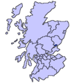 Location in Scotland
 -
 Satellite image
 -
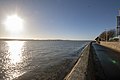
 View across the Firth of Tay showing Tay Road Bridge
 -
 Tay Road Bridge
 -
 Tay Rail Bridge
 -
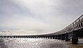 Tay Rail Bridge
 -
 V&A Museum, Dundee
 -
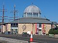
 McManus Galleries
 -
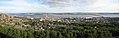 Dundee and Firth of Tay, seen from Dundee Law.
 -
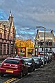
 Hilltown
 -
 Tay Hotel
 -
 Dundee House
 -
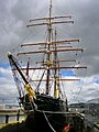 RSS Discovery
 -
 RRS Discovery Point
 -
 Broughty Castle
 -
 Cox's Stack
 -
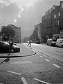
 Alexander Street
 -
 Stirling Street
 -
 Morgan Academy
 -
 Tay Rail Bridge
 -
 V&A Museum Dundee


.jpg)


.jpg)


.jpg)