File:1967 Six Day War - Battle of Golan Heights.svg
Jump to navigation
Jump to search

Size of this PNG preview of this SVG file: 613 × 599 pixels. Other resolutions: 245 × 240 pixels | 491 × 480 pixels | 785 × 768 pixels | 1,047 × 1,024 pixels | 2,094 × 2,048 pixels | 904 × 884 pixels.
Original file (SVG file, nominally 904 × 884 pixels, file size: 412 KB)
Captions
Captions
Add a one-line explanation of what this file represents
| Description |
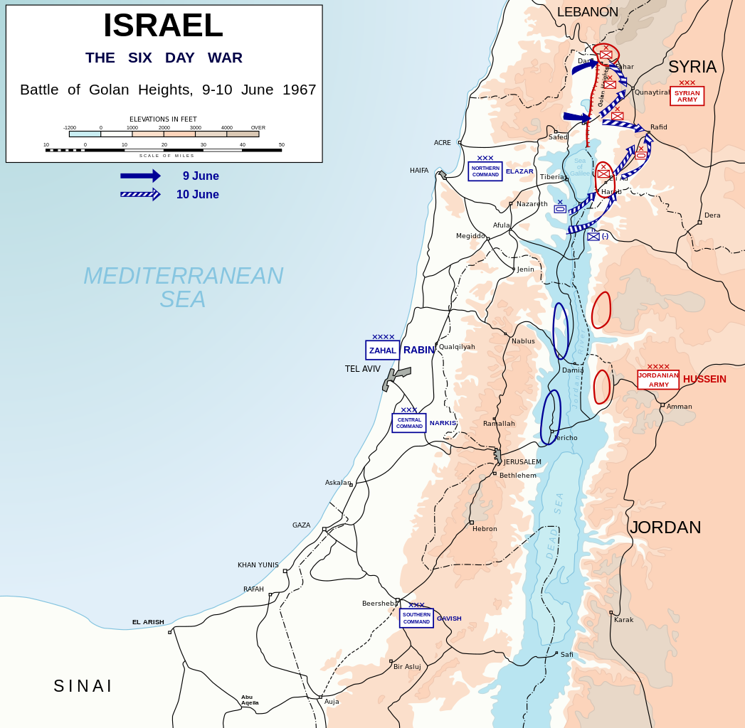
English: Map depicting battle of Golan Heights (9-10 June, 1967) during Six-Day War. Symbols used in the map are NATO military symbols.
Català: Mapa que mostra la batalla dels Alts del Golan (9-10 de juny, 1967) durant la Guerra dels Sis Dies. Els símbols que s'utilitzen al mapa són els símbols militars de l'OTAN. |
| Date | (UTC) |
| Source | |
| Author | Honza Havlíček |
| Other versions |
|


| I, the copyright holder of this work, release this work into the public domain. This applies worldwide. In some countries this may not be legally possible; if so: I grant anyone the right to use this work for any purpose, without any conditions, unless such conditions are required by law. |
File history
Click on a date/time to view the file as it appeared at that time.
| Date/Time | Thumbnail | Dimensions | User | Comment | |
|---|---|---|---|---|---|
| current | 23:12, 29 September 2023 | | 904 × 884 (412 KB) | Joutbis (talk | contribs) | File uploaded using svgtranslate tool (https://svgtranslate.toolforge.org/). Added translation for ca. |
| 21:43, 19 November 2009 |  | 904 × 884 (373 KB) | Honza.havlicek (talk | contribs) | {{Information |Description={{en|1=Map depicting battle of Golan Heights (9-10 June, 1967) during Six-Day War. Symbols used in the map are {{w|NATO_map_symbols|NATO military symbols}}.}} |Source=*Israel 1949-1967.svg *[[:File |
You cannot overwrite this file.
File usage on Commons
The following 7 pages use this file:
- 1967
- User:Magog the Ogre/Maps of conflicts/2023 September
- User:Magog the Ogre/Multilingual legend/2023 September 26-30
- File:1967 Six Day War - Battle of Golan Heights-es.svg
- File:1967 Six Day War - Battle of Golan Heights.jpg
- File:1967 Six Day War - Battle of Golan Heights.svg
- File:Battle of Golan Heights-hu.svg
File usage on other wikis
The following other wikis use this file:
- Usage on af.wikipedia.org
- Usage on azb.wikipedia.org
- Usage on az.wikipedia.org
- Usage on ca.wikipedia.org
- Usage on cs.wikipedia.org
- Usage on da.wikipedia.org
- Usage on de.wikipedia.org
- Usage on en.wikipedia.org
- Usage on eo.wikipedia.org
- Usage on eu.wikipedia.org
- Usage on fi.wikipedia.org
- Usage on id.wikipedia.org
- Usage on it.wikipedia.org
- Usage on ja.wikipedia.org
- Usage on krc.wikipedia.org
- Usage on lv.wikipedia.org
- Usage on nl.wikipedia.org
- Usage on no.wikipedia.org
- Usage on pl.wikipedia.org
- Usage on ru.wikipedia.org
- Usage on sk.wikipedia.org
- Usage on sq.wikipedia.org
- Usage on sr.wikipedia.org
- Usage on th.wikipedia.org
- Usage on tr.wikipedia.org
- Usage on uk.wikipedia.org
- Usage on vi.wikipedia.org
- Usage on zh.wikipedia.org