File:Burgruine Aichach in Sankt Oswald Kastelruth.JPG
Original file (7,360 × 4,912 pixels, file size: 24.64 MB, MIME type: image/jpeg)
Captions
Summary
[edit]DescriptionBurgruine Aichach in Sankt Oswald Kastelruth.JPG |
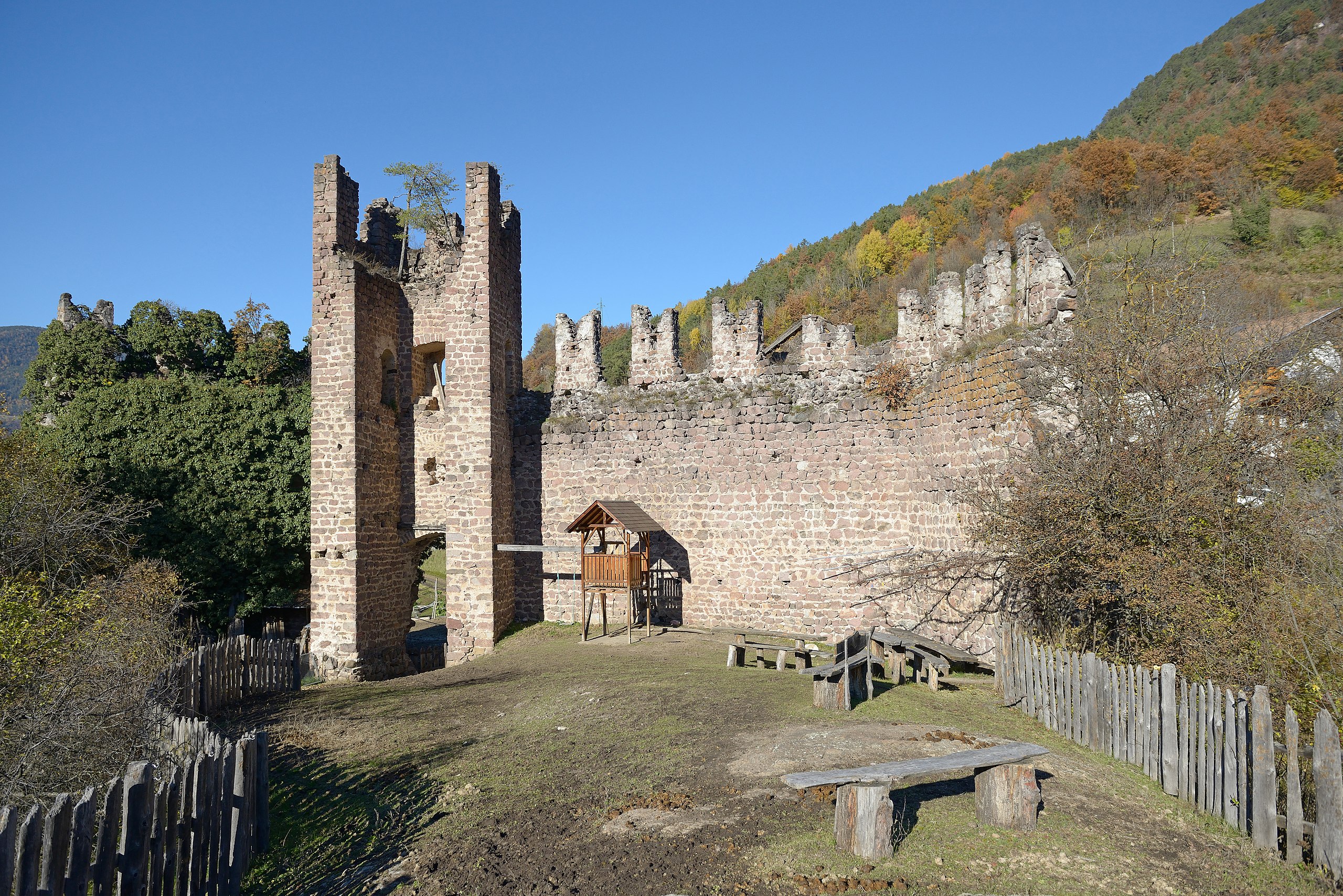
Deutsch: Burgruine Aichach, 1234 erstmals erwähnt in St. Oswald Kastelruth English: Castel ruin Aichach in St. Oswald Kastelruth |
||||||
Date | |||||||
Source | Own work | ||||||
Author |
|
||||||
Permission (Reusing this file) |
I, the copyright holder of this work, hereby publish it under the following licenses: This file is licensed under the Creative Commons Attribution-Share Alike 3.0 Unported license.
You may select the license of your choice. |
Object location | 46° 32′ 43.46″ N, 11° 31′ 38.72″ E | View this and other nearby images on: OpenStreetMap | 46.545406; 11.527421 |
---|
This image has been assessed using the Quality image guidelines and is considered a Quality image.
العربية ∙ جازايرية ∙ беларуская ∙ беларуская (тарашкевіца) ∙ български ∙ বাংলা ∙ català ∙ čeština ∙ Cymraeg ∙ Deutsch ∙ Schweizer Hochdeutsch ∙ Zazaki ∙ Ελληνικά ∙ English ∙ Esperanto ∙ español ∙ eesti ∙ euskara ∙ فارسی ∙ suomi ∙ français ∙ galego ∙ עברית ∙ हिन्दी ∙ hrvatski ∙ magyar ∙ հայերեն ∙ Bahasa Indonesia ∙ italiano ∙ 日本語 ∙ Jawa ∙ ქართული ∙ 한국어 ∙ kurdî ∙ Lëtzebuergesch ∙ lietuvių ∙ македонски ∙ മലയാളം ∙ मराठी ∙ Bahasa Melayu ∙ Nederlands ∙ Norfuk / Pitkern ∙ polski ∙ português ∙ português do Brasil ∙ rumantsch ∙ română ∙ русский ∙ sicilianu ∙ slovenčina ∙ slovenščina ∙ shqip ∙ српски / srpski ∙ svenska ∙ தமிழ் ∙ తెలుగు ∙ ไทย ∙ Tagalog ∙ toki pona ∙ Türkçe ∙ українська ∙ vèneto ∙ Tiếng Việt ∙ 中文 ∙ 中文(简体) ∙ 中文(繁體) ∙ +/− |
File history
Click on a date/time to view the file as it appeared at that time.
Date/Time | Thumbnail | Dimensions | User | Comment | |
---|---|---|---|---|---|
current | 22:48, 16 November 2012 | 7,360 × 4,912 (24.64 MB) | Moroder (talk | contribs) | == {{int:filedesc}} == {{Information |Description={{Denkmalgeschütztes Objekt Südtirol|1=15330}}{{de|1=Burgruine Aichach, 1234 erstmals erwähnt in St. Oswald Kastelruth}}{{en|1=Castel ruin Aichach in St. Oswald [[:en:Kastelruth|... |
You cannot overwrite this file.
File usage on Commons
The following 6 pages use this file:
- User talk:Moroder/Archives 2012-4
- Commons:Quality images/Subject/Places/Man made structures/Buildings, Exterior/Part 3
- Commons:Quality images candidates/Archives November 2012
- File:Burgruine Aichach in Sankt Oswald Kastelruth.JPG
- File:Langkofel Schlern über Seis.jpg
- Category:Burgruine Aichach (Kastelruth)
File usage on other wikis
The following other wikis use this file:
- Usage on de.wikipedia.org
- Usage on it.wikipedia.org
- Usage on www.wikidata.org
Metadata
This file contains additional information such as Exif metadata which may have been added by the digital camera, scanner, or software program used to create or digitize it. If the file has been modified from its original state, some details such as the timestamp may not fully reflect those of the original file. The timestamp is only as accurate as the clock in the camera, and it may be completely wrong.
Camera manufacturer | NIKON CORPORATION |
---|---|
Camera model | NIKON D800 |
Author | Wolfgang Moroder |
Copyright holder |
|
Exposure time | 1/2,500 sec (0.0004) |
F-number | f/5 |
ISO speed rating | 400 |
Date and time of data generation | 14:15, 16 November 2012 |
Lens focal length | 24 mm |
User comments | Wolfgang Moroder lusenberg.com |
Orientation | Normal |
Horizontal resolution | 300 dpi |
Vertical resolution | 300 dpi |
Software used | Adobe Photoshop Elements 5.0 Windows |
File change date and time | 23:34, 16 November 2012 |
Y and C positioning | Centered |
Pair of black and white reference values |
|
Exposure Program | Aperture priority |
Exif version | 2.3 |
Date and time of digitizing | 14:15, 16 November 2012 |
Meaning of each component |
|
APEX exposure bias | 0 |
Maximum land aperture | 3 APEX (f/2.83) |
Metering mode | Pattern |
Light source | Unknown |
Flash | Flash did not fire, compulsory flash suppression |
DateTime subseconds | 50 |
DateTimeOriginal subseconds | 50 |
DateTimeDigitized subseconds | 50 |
Supported Flashpix version | 1 |
Color space | sRGB |
Sensing method | One-chip color area sensor |
File source | Digital still camera |
Scene type | A directly photographed image |
Custom image processing | Normal process |
Exposure mode | Auto exposure |
White balance | Auto white balance |
Digital zoom ratio | 1 |
Focal length in 35 mm film | 24 mm |
Scene capture type | Standard |
Scene control | Low gain up |
Contrast | Normal |
Saturation | Normal |
Sharpness | Normal |
Subject distance range | Unknown |
GPS tag version | 0.0.3.2 |
Supported Flashpix version | 1 |
Image width | 7,360 px |
Image height | 4,912 px |
Date metadata was last modified | 00:34, 17 November 2012 |
IIM version | 2 |
Structured data
Items portrayed in this file
depicts
16 November 2012
46°32'43.462"N, 11°31'38.716"E
image/jpeg
7bfb3d7ab2bd632f0325fa0be2bda89c47b087bc
25,841,401 byte
4,912 pixel
7,360 pixel
- Cultural heritage monuments in South Tyrol with known IDs
- Photos by Moroder for Cultural heritage monuments in South Tyrol
- CC-BY-SA-3.0
- License migration redundant
- GFDL
- Self-published work
- Files with coordinates missing SDC location of creation
- Quality images of South Tyrol
- Quality images by Moroder
- Quality images
- Quality images missing SDC depicts