File:Carte Lewis-Clark Expedition-fr.svg
Jump to navigation
Jump to search

Size of this PNG preview of this SVG file: 800 × 524 pixels. Other resolutions: 320 × 209 pixels | 640 × 419 pixels | 1,024 × 670 pixels | 1,280 × 838 pixels | 2,560 × 1,676 pixels | 906 × 593 pixels.
Original file (SVG file, nominally 906 × 593 pixels, file size: 368 KB)
Captions
Captions
Add a one-line explanation of what this file represents
Summary
[edit]
| Description |
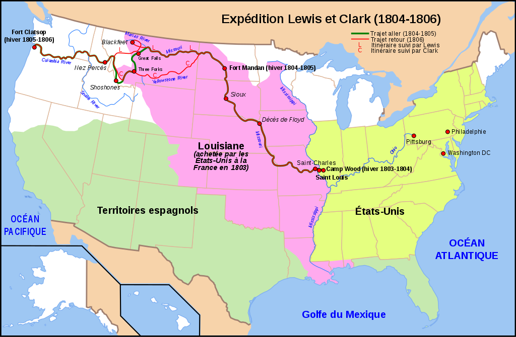
English: Map of the Lewis and Clark Expedition (1804-1806)
Français : Carte de l'expédition Lewis and Clark (1804-1806) |
| Date | |
| Source | Travail personnel (own work) d'après cette carte vierge et les données de cette carte |
| Author | Sardon |
| Other versions | Image:Carte Lewis-Clark Expedition.png, Image:Carte Lewis-Clark Expedition-en.png |

|
This SVG file contains embedded text that can be translated into your language, using any capable SVG editor, text editor or the SVG Translate tool. For more information see: About translating SVG files. |
Licensing
[edit]
I, the copyright holder of this work, hereby publish it under the following licenses:

|
Permission is granted to copy, distribute and/or modify this document under the terms of the GNU Free Documentation License, Version 1.2 or any later version published by the Free Software Foundation; with no Invariant Sections, no Front-Cover Texts, and no Back-Cover Texts. A copy of the license is included in the section entitled GNU Free Documentation License. |
This file is licensed under the Creative Commons Attribution-Share Alike 3.0 Unported, 2.5 Generic, 2.0 Generic and 1.0 Generic license.
- You are free:
- to share – to copy, distribute and transmit the work
- to remix – to adapt the work
- Under the following conditions:
- attribution – You must give appropriate credit, provide a link to the license, and indicate if changes were made. You may do so in any reasonable manner, but not in any way that suggests the licensor endorses you or your use.
- share alike – If you remix, transform, or build upon the material, you must distribute your contributions under the same or compatible license as the original.
You may select the license of your choice.
File history
Click on a date/time to view the file as it appeared at that time.
| Date/Time | Thumbnail | Dimensions | User | Comment | |
|---|---|---|---|---|---|
| current | 09:29, 18 January 2009 | | 906 × 593 (368 KB) | Sardon (talk | contribs) | Coquilles d'affichage svg |
| 09:25, 18 January 2009 |  | 906 × 593 (366 KB) | Sardon (talk | contribs) | Précision trajet aller - trajet retour - séparation des itinéraires de Lewis et de Clark. | |
| 20:39, 17 January 2009 |  | 906 × 593 (353 KB) | Sardon (talk | contribs) | {{Information |Description={{en|1=Map of the Lewis and Clark Expedition (1804-1806)}} {{fr|1=Carte de l'expédition Lewis and Clark (1804-1806)}} |Source=Travail personnel (own work) d'après cette carte vierge |
You cannot overwrite this file.
File usage on Commons
There are no pages that use this file.
File usage on other wikis
The following other wikis use this file:
- Usage on ar.wikipedia.org
- Usage on fr.wikipedia.org