File:Culture ceramiche del Vicino Oriente nel medio Halaf - 5200-4500 a.C.jpg
Jump to navigation
Jump to search

Size of this preview: 790 × 600 pixels. Other resolutions: 316 × 240 pixels | 632 × 480 pixels | 1,012 × 768 pixels | 1,280 × 972 pixels | 2,560 × 1,943 pixels | 3,820 × 2,900 pixels.
Original file (3,820 × 2,900 pixels, file size: 1.06 MB, MIME type: image/jpeg)
Captions
Captions
Add a one-line explanation of what this file represents
Summary
[edit]
| Description |
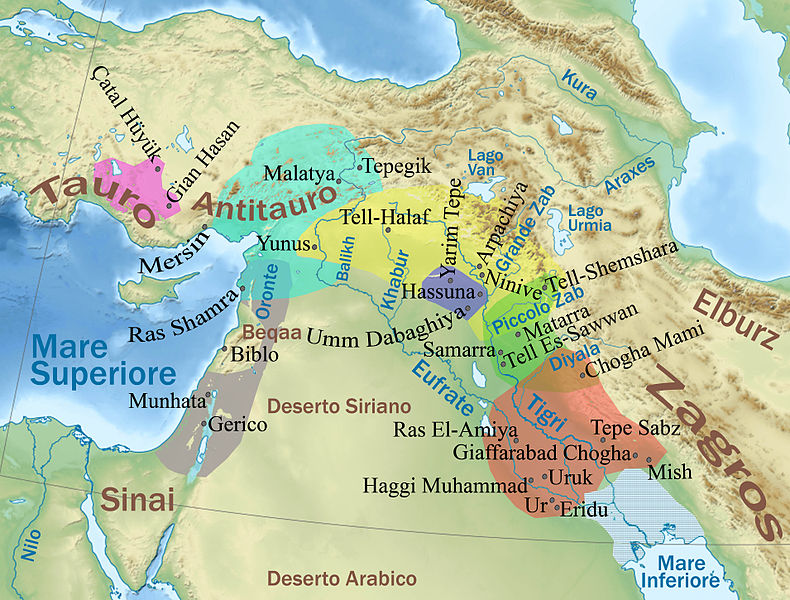
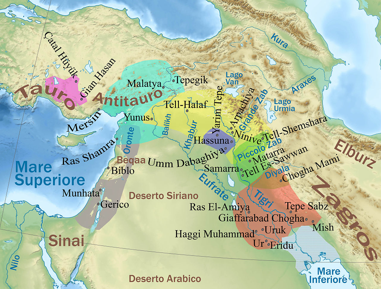
English: Physical map of the ancient Near East with cultures of the Middle Halaf period (more info in the Italian description) Italiano: Mappa delle culture ceramiche nel periodo medio Halaf (5200-4500 a.C.); Legenda (da sud a nord approssimativamente):
|
| Date | (UTC) |
| Source |
|
| Author |
|
| This is a retouched picture, which means that it has been digitally altered from its original version. Modifications: Added details about VI-V millennium BC cultures. The original can be viewed here: Middle East topographic map-blank.svg:
|
Licensing
[edit]
I, the copyright holder of this work, hereby publish it under the following licenses:
This file is licensed under the Creative Commons Attribution-Share Alike 3.0 Unported, 2.5 Generic, 2.0 Generic and 1.0 Generic license.
- You are free:
- to share – to copy, distribute and transmit the work
- to remix – to adapt the work
- Under the following conditions:
- attribution – You must give appropriate credit, provide a link to the license, and indicate if changes were made. You may do so in any reasonable manner, but not in any way that suggests the licensor endorses you or your use.
- share alike – If you remix, transform, or build upon the material, you must distribute your contributions under the same or compatible license as the original.

|
Permission is granted to copy, distribute and/or modify this document under the terms of the GNU Free Documentation License, Version 1.2 or any later version published by the Free Software Foundation; with no Invariant Sections, no Front-Cover Texts, and no Back-Cover Texts. A copy of the license is included in the section entitled GNU Free Documentation License. |
You may select the license of your choice.
Original upload log
[edit]
This image is a derivative work of the following images:
- File:Middle_East_topographic_map-blank.svg licensed with Cc-by-sa-3.0,2.5,2.0,1.0, GFDL
- 2010-11-03T17:52:56Z Sémhur 3097x1938 (10510751 Bytes) == {{int:filedesc}} == {{Information |Description={{Multilingual description |en= Blank physical map of the [[:en:Middle East|Middle East]] |fr= Carte physique vierge du [[:fr:Moyen-Orient|Moyen-Orient]]. }} |Source={{own}}.
Uploaded with derivativeFX
File history
Click on a date/time to view the file as it appeared at that time.
| Date/Time | Thumbnail | Dimensions | User | Comment | |
|---|---|---|---|---|---|
| current | 17:57, 20 March 2011 | | 3,820 × 2,900 (1.06 MB) | Pequod76 (talk | contribs) | {{Information |Description={{Multilingual description |en= Blank physical map of the Middle East |fr= Carte physique vierge du Moyen-Orient. }} |Source=*File:Middle_East_topographic_map-blank.svg |Date=2011-0 |
You cannot overwrite this file.
File usage on Commons
The following page uses this file:
File usage on other wikis
The following other wikis use this file:
- Usage on bg.wikipedia.org
- Usage on ca.wikipedia.org
- Usage on cs.wikipedia.org
- Usage on en.wikipedia.org
- Usage on eo.wikipedia.org
- Usage on es.wikipedia.org
- Usage on fa.wikipedia.org
- Usage on fi.wikipedia.org
- Usage on fr.wikipedia.org
- Usage on it.wikipedia.org
- Çatalhöyük
- Protostoria del Vicino Oriente
- Eridu
- Cronologia della protostoria
- Discussioni utente:Pequod76/Archivio26
- Hassuna
- Cultura di Hassuna
- Cultura di Halaf
- Vicino Oriente antico
- Storia del Vicino Oriente antico
- Cultura di Samarra
- Haggi Muhammad
- Progetto:Laboratorio grafico/Immagini da migliorare/Archivio risolte/131
- Discussioni template:Legenda
- Discussioni portale:Vicino Oriente antico
- Tepe Sabz
- Usage on pl.wikipedia.org
- Usage on ru.wikipedia.org
- Usage on www.wikidata.org
Metadata
Categories:
- Maps of ancient Anatolia
- Maps of the prehistory of Mesopotamia
- Halaf culture
- Maps of the Ubaid Period in Mesopotamia
- Syrian Desert
- Orontes River
- Balikh River
- Euphrates
- Khabur River
- Maps of the Tigris
- Great Zab
- Kura River
- Maps of the Diyala River
- Aras River
- Maps of the Zagros Mountains
- Taurus Mountains
- Anti-Taurus Mountains
- Lake Urmia maps
- Illustrations from books published by Laterza