File:Whittle Rock main reef.png
Jump to navigation
Jump to search

Size of this preview: 603 × 599 pixels. Other resolutions: 241 × 240 pixels | 483 × 480 pixels | 773 × 768 pixels | 1,030 × 1,024 pixels | 2,060 × 2,048 pixels | 7,793 × 7,747 pixels.
Original file (7,793 × 7,747 pixels, file size: 5.79 MB, MIME type: image/png)
Captions
Captions
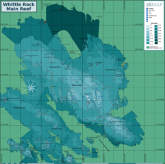
Map of the dive site at the main reef at Whittle Rock in False Bay, Western Cape.
Summary[edit]
| Description |
English: Map of the dive site at the main reef at Whittle Rock in False Bay, Western Cape. |
| Date | |
| Source | Peter Southwood |
| Author | Peter Southwood |
Licensing[edit]
Peter Southwood (User:Pbsouthwood), the copyright holder of this work, hereby publishes it under the following license:
This file is licensed under the Creative Commons Attribution-Share Alike 3.0 Unported license.
Attribution: Peter Southwood (User:Pbsouthwood)
- You are free:
- to share – to copy, distribute and transmit the work
- to remix – to adapt the work
- Under the following conditions:
- attribution – You must give appropriate credit, provide a link to the license, and indicate if changes were made. You may do so in any reasonable manner, but not in any way that suggests the licensor endorses you or your use.
- share alike – If you remix, transform, or build upon the material, you must distribute your contributions under the same or compatible license as the original.
Original upload log[edit]
| This file was imported from Wikivoyage WTS. |
The original description page was here. All following user names refer to wts.wikivoyage-old.
org:
- 2011-07-18 15:30 (WT-shared) Pbsouthwood[dead link] 1857×1370 (221780 bytes) {{Imagecredit|credit=Peter Southwood|captureDate=July 2011|location=False Bay, Western cape|source=Peter Southwood|caption=Map of the dive s (Import from wikitravel.org/shared)
- 2012-09-10 10:41 Pbsouthwood[dead link] 3000×2212 (395444 bytes) rm logo
File history
Click on a date/time to view the file as it appeared at that time.
| Date/Time | Thumbnail | Dimensions | User | Comment | |
|---|---|---|---|---|---|
| current | 06:36, 1 December 2019 | | 7,793 × 7,747 (5.79 MB) | Pbsouthwood (talk | contribs) | Added some 30m contour to the nortwest |
| 09:47, 25 November 2019 |  | 7,793 × 7,747 (5.7 MB) | Pbsouthwood (talk | contribs) | Added section of northern perimeter and a few other details | |
| 12:45, 27 October 2019 |  | 7,793 × 7,747 (5.51 MB) | Pbsouthwood (talk | contribs) | Added contours north of the main reef. and Kelly's anchor | |
| 16:27, 8 October 2019 |  | 7,792 × 6,578 (5.31 MB) | Pbsouthwood (talk | contribs) | Added 24m contour at west side | |
| 19:09, 21 September 2019 |  | 7,792 × 6,578 (5.22 MB) | Pbsouthwood (talk | contribs) | Updated perimeters and 24m contour | |
| 14:17, 19 August 2019 |  | 7,792 × 6,578 (4.86 MB) | Pbsouthwood (talk | contribs) | Updated to added Flash Pinnacle | |
| 09:00, 22 July 2019 |  | 7,792 × 6,578 (4.49 MB) | Pbsouthwood (talk | contribs) | Added contours at Whaleback Rock and positions of a few unsurveyed pinnacles | |
| 09:45, 24 June 2019 |  | 7,792 × 6,578 (4.25 MB) | Pbsouthwood (talk | contribs) | Added 27m contour to north-east | |
| 09:18, 28 May 2019 |  | 7,792 × 6,578 (4.08 MB) | Pbsouthwood (talk | contribs) | Trim back to focus on main reef | |
| 16:47, 15 April 2019 |  | 7,793 × 8,365 (4.34 MB) | Pbsouthwood (talk | contribs) | added 24m contour at caves complex |
You cannot overwrite this file.
File usage on Commons
The following 35 pages use this file:
- User:Chumwa/OgreBot/Potential transport maps/2019 December 1-10
- User:Chumwa/OgreBot/Potential transport maps/2019 November 21-30
- User:Chumwa/OgreBot/Potential transport maps/2019 October 21-31
- User:Chumwa/OgreBot/Transport Maps/2019 December 1-10
- User:Chumwa/OgreBot/Transport Maps/2019 November 21-30
- User:Chumwa/OgreBot/Transport Maps/2019 October 21-31
- User:Chumwa/OgreBot/Travel and communication maps/2016 May 11-20
- User:Chumwa/OgreBot/Travel and communication maps/2017 April 21-30
- User:Chumwa/OgreBot/Travel and communication maps/2017 August 1-10
- User:Chumwa/OgreBot/Travel and communication maps/2017 August 21-31
- User:Chumwa/OgreBot/Travel and communication maps/2017 December 21-31
- User:Chumwa/OgreBot/Travel and communication maps/2017 July 21-31
- User:Chumwa/OgreBot/Travel and communication maps/2017 November 11-20
- User:Chumwa/OgreBot/Travel and communication maps/2017 October 21-31
- User:Chumwa/OgreBot/Travel and communication maps/2018 April 1-10
- User:Chumwa/OgreBot/Travel and communication maps/2018 April 21-30
- User:Chumwa/OgreBot/Travel and communication maps/2018 December 1-10
- User:Chumwa/OgreBot/Travel and communication maps/2018 December 21-31
- User:Chumwa/OgreBot/Travel and communication maps/2018 January 11-20
- User:Chumwa/OgreBot/Travel and communication maps/2018 May 1-10
- User:Chumwa/OgreBot/Travel and communication maps/2018 May 21-31
- User:Chumwa/OgreBot/Travel and communication maps/2018 September 1-10
- User:Chumwa/OgreBot/Travel and communication maps/2019 April 11-20
- User:Chumwa/OgreBot/Travel and communication maps/2019 August 11-20
- User:Chumwa/OgreBot/Travel and communication maps/2019 December 1-10
- User:Chumwa/OgreBot/Travel and communication maps/2019 January 11-20
- User:Chumwa/OgreBot/Travel and communication maps/2019 July 21-31
- User:Chumwa/OgreBot/Travel and communication maps/2019 June 21-30
- User:Chumwa/OgreBot/Travel and communication maps/2019 March 1-10
- User:Chumwa/OgreBot/Travel and communication maps/2019 May 21-31
- User:Chumwa/OgreBot/Travel and communication maps/2019 November 21-30
- User:Chumwa/OgreBot/Travel and communication maps/2019 October 1-10
- User:Chumwa/OgreBot/Travel and communication maps/2019 October 21-31
- User:Chumwa/OgreBot/Travel and communication maps/2019 September 21-30
- Commons:Files used on the OpenStreetMap Wiki/29
File usage on other wikis
The following other wikis use this file: