File:"This means something. This is important" (19967592275).jpg
Fichier d’origine (3 264 × 2 448 pixels, taille du fichier : 2,32 Mio, type MIME : image/jpeg)
Légendes
Légendes
Description
[modifier].jpg&action=edit§ion=1)
| Description |
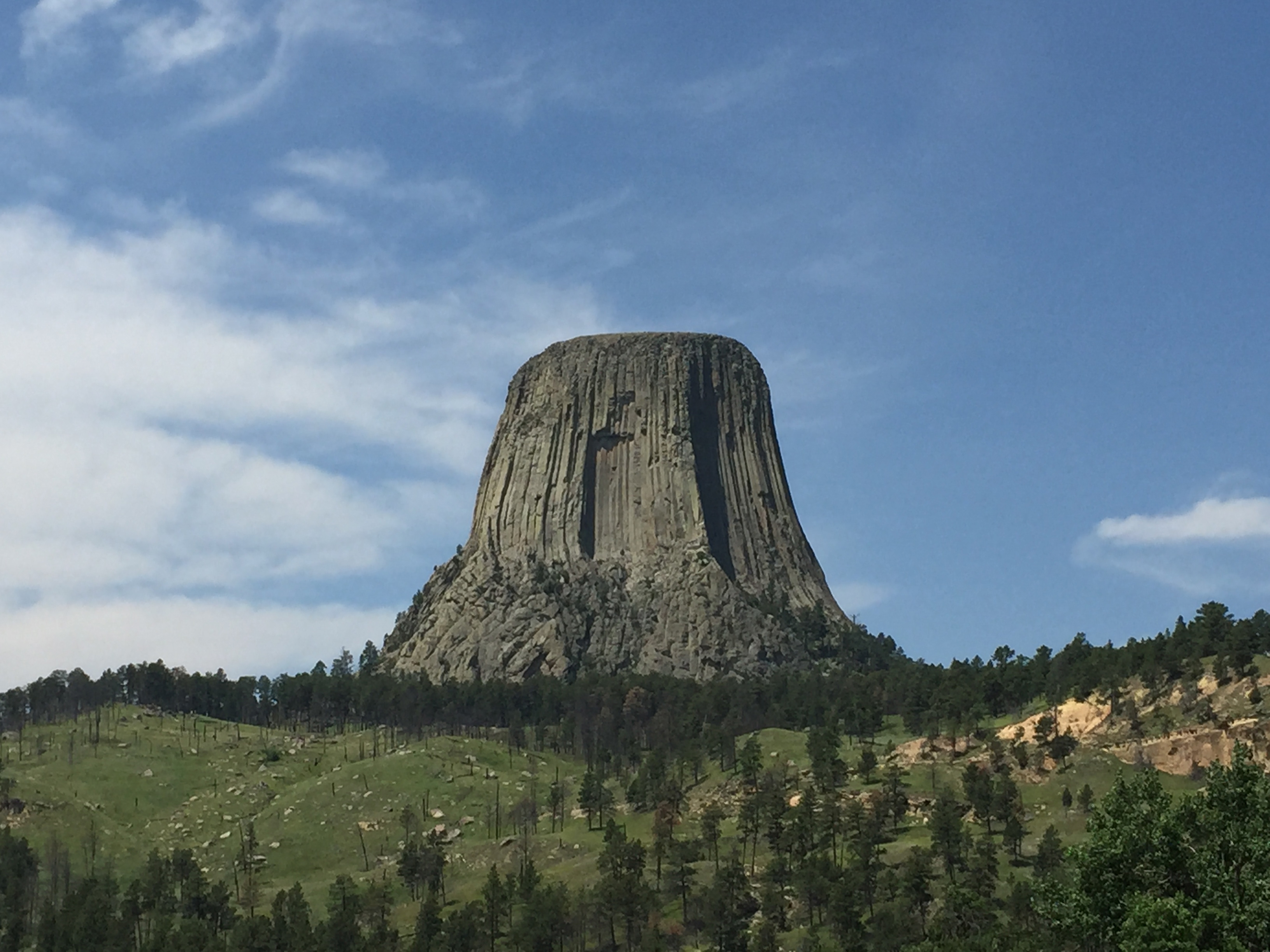
"This means something. This is important." — If you're familiar with that famous movie line from "Close Encounters of the Third Kind" then you'll remember Richard Dreyfus carving a vision of something out of mashed potatoes. The vision, of course, was Devils Tower. While this isn't a shot of a well-sculpted potato heap, it's definitely the real Devils Tower in Wyoming. Devils Tower is an eroded laccolith in the Black Hills of Wyoming. A laccolith forms when molten magma forces its way into a rock formation, then cools and hardens. As the surrounding rock erodes away over time, the hardened former magma remains. The streaked surface of Devils Tower reflects the polygonal shaped fractures (columnar joints) that formed as magma contracted as it cooled and hardened. Devils Tower rises 1,267 feet above the nearby Belle Fourche River and according to the National Park Service, the summit is roughly the size of a football field. Photo credit: Alex Demas, USGS. You can learn more about Devils Tower National Monument at: www.nps.gov/deto/. |
| Date | |
| Source | "This means something. This is important" |
| Auteur | U.S. Geological Survey from Reston, VA, USA |
Conditions d’utilisation
[modifier].jpg&action=edit§ion=2)
- Vous êtes libre :
- de partager – de copier, distribuer et transmettre cette œuvre
- d’adapter – de modifier cette œuvre
- Sous les conditions suivantes :
- paternité – Vous devez donner les informations appropriées concernant l'auteur, fournir un lien vers la licence et indiquer si des modifications ont été faites. Vous pouvez faire cela par tout moyen raisonnable, mais en aucune façon suggérant que l’auteur vous soutient ou approuve l’utilisation que vous en faites.
| Cette image, qui provient de Flickr, a été vérifiée le 21:44, 3 August 2015 (UTC) par l'administrateur ou l'utilisateur de confiance (trusted user) ww2censor, qui a confirmé qu'à cette date, elle était publiée sur Flickr sous cette licence. |
Cette image est placée dans le domaine public parce qu'elle contient des éléments issus de l'United States Geological Survey, une agence du Département de l'Intérieur des États-Unis. Pour plus d'information, consultez la politique officielle de copyright de l'USGS (en anglais)
|
Historique du fichier
Cliquer sur une date et heure pour voir le fichier tel qu'il était à ce moment-là.
| Date et heure | Vignette | Dimensions | Utilisateur | Commentaire | |
|---|---|---|---|---|---|
| actuel | 3 août 2015 à 19:11 | | 3 264 × 2 448 (2,32 Mio) | Wilfredor (d | contributions) | Transferred from Flickr via Flickr2Commons |
Vous ne pouvez pas remplacer ce fichier.
Utilisations locales du fichier
La page suivante utilise ce fichier :
Utilisations du fichier sur d’autres wikis
Les autres wikis suivants utilisent ce fichier :
- Utilisation sur bn.wikipedia.org
- Utilisation sur en.wikipedia.org
- Utilisation sur fr.wikipedia.org
- Utilisation sur ja.wikipedia.org
- Utilisation sur kn.wikipedia.org
- Utilisation sur sr.wikipedia.org
- Utilisation sur tr.wikipedia.org
- Utilisation sur uk.wikipedia.org
- Utilisation sur www.wikidata.org
- Utilisation sur zh.wikipedia.org
.jpg&oldid=731929455)