File:Діорама. Битва за Дніпро в районі Переяслава і створення Букринського плацдарму восени 1943 року.tif
Jump to navigation
Jump to search

Size of this JPG preview of this TIF file: 800 × 222 pixels. Other resolutions: 320 × 89 pixels | 640 × 178 pixels | 1,024 × 284 pixels | 1,280 × 356 pixels | 2,560 × 711 pixels | 8,928 × 2,480 pixels.
Original file (8,928 × 2,480 pixels, file size: 63.37 MB, MIME type: image/tiff)
Captions
Captions
Add a one-line explanation of what this file represents
Summary[edit]
| Description |
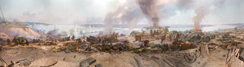
Українська: Вознесенський собор (діорама), Переяслав-Хмельницький, вул. Г. Сковороди, 54
|
||
| Date | |||
| Source | Own work | ||
| Author | Забарило Павло Миколайович |
| Camera location | | View this and other nearby images on: OpenStreetMap |
|---|
Licensing[edit]
I, the copyright holder of this work, hereby publish it under the following license:
This file is licensed under the Creative Commons Attribution-Share Alike 4.0 International license.
- You are free:
- to share – to copy, distribute and transmit the work
- to remix – to adapt the work
- Under the following conditions:
- attribution – You must give appropriate credit, provide a link to the license, and indicate if changes were made. You may do so in any reasonable manner, but not in any way that suggests the licensor endorses you or your use.
- share alike – If you remix, transform, or build upon the material, you must distribute your contributions under the same or compatible license as the original.

|
This image was uploaded as part of Wiki Loves Monuments 2017.
|
 |
File history
Click on a date/time to view the file as it appeared at that time.
| Date/Time | Thumbnail | Dimensions | User | Comment | |
|---|---|---|---|---|---|
| current | 11:50, 29 September 2017 | 8,928 × 2,480 (63.37 MB) | Микола Губочкін (talk | contribs) | User created page with UploadWizard |
You cannot overwrite this file.
File usage on Commons
There are no pages that use this file.
File usage on other wikis
The following other wikis use this file:
- Usage on uk.wikipedia.org