File:מכתש רמון - גלישת עננים (cropped).jpg
跳转到导航
跳转到搜索

本预览的尺寸:800 × 497像素。 其他分辨率:320 × 199像素 | 640 × 398像素 | 1,024 × 636像素 | 1,280 × 796像素 | 2,560 × 1,591像素 | 3,604 × 2,240像素。
原始文件 (3,604 × 2,240像素,文件大小:3.1 MB,MIME类型:image/jpeg)
说明
说明
添加一行文字以描述该文件所表现的内容
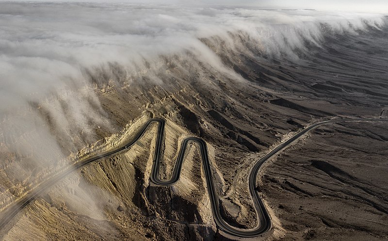
Cloud waterfall over highway Mitzpe Ramon, Israel
摘要[编辑]
| 描述 |
עברית: מכתש רמון הוא המכתש האירוזי הגדול בעולם. הוא מצוי בישראל ומהווה אחד מחמשת המכתשים שבנגב. נופו של מכתש רמון הוא ייחודי. על קצה המכתש מצויה העיירה מצפה רמון. English: Aerial photo of clouds gliding in Makhtesh Ramon, Negev desert, Israel.
Español: Vista aérea de nubes deslizándose en Makhtesh Ramon, un circo de erosión kárstica en el desierto de Néguev, Israel
Polski: Widok z powietrza na chmury ześlizgujące się po zboczu krateru Ramon na pustyni Negew w Izraelu.
Português: Vista aérea de nuvens deslizando em Makhtesh Ramon, um circo de erosão cársica no deserto de Neguev, Israel.
Čeština: Letecká fotografie mraků sestupujících po úbočí kráteru Machteš Ramon v Negevské poušti, Izrael.
Français : Photo aérienne de nuages glissants dans le cratère Ramon, dans le désert Néguev, en Israël.
|
||
| 日期 | |||
| 来源 | 自己的作品 | ||
| 作者 | ZeevStein | ||
| 其他版本 |

| 相机位置 | | 在以下服务上查看本图像和附近其他图像: OpenStreetMap |
|---|
评价[编辑]
|

.jpg&action=edit§ion=1)
.jpg¶ms=030.617013_N_0034.816392_E_globe:Earth_type:camera__&language=zh)
.jpg&action=edit§ion=2)
本图像被选为2020年4月17日的今日图片。其说明如下: 其他语言:
Čeština: Letecká fotografie mraků sestupujících po úbočí kráteru Machteš Ramon v Negevské poušti, Izrael. Español: Vista aérea de nubes deslizándose en Makhtesh Ramon, un circo de erosión kárstica en el desierto de Néguev, Israel. Français : Photo aérienne de nuages glissants dans le cratère Ramon, dans le désert Néguev, en Israël. Polski: Widok z powietrza na chmury ześlizgujące się po zboczu krateru Ramon na pustyni Negew w Izraelu. Português: Vista aérea de nuvens deslizando em Makhtesh Ramon, um circo de erosão cársica no deserto de Neguev, Israel. |
许可协议[编辑]
.jpg&action=edit§ion=3)
我,本作品著作权人,特此采用以下许可协议发表本作品:
本文件采用知识共享署名-相同方式共享 4.0 国际许可协议授权。
- 您可以自由地:
- 共享 – 复制、发行并传播本作品
- 修改 – 改编作品
- 惟须遵守下列条件:
- 署名 – 您必须对作品进行署名,提供授权条款的链接,并说明是否对原始内容进行了更改。您可以用任何合理的方式来署名,但不得以任何方式表明许可人认可您或您的使用。
- 相同方式共享 – 如果您再混合、转换或者基于本作品进行创作,您必须以与原先许可协议相同或相兼容的许可协议分发您贡献的作品。
文件历史
点击某个日期/时间查看对应时刻的文件。
| 日期/时间 | 缩略图 | 大小 | 用户 | 备注 | |
|---|---|---|---|---|---|
| 当前 | 2020年1月10日 (五) 23:01 | | 3,604 × 2,240(3.1 MB) | Andrew J.Kurbiko(留言 | 贡献) | cropped |
| 2020年1月10日 (五) 22:54 |  | 3,587 × 2,236(7.01 MB) | Andrew J.Kurbiko(留言 | 贡献) | File:מכתש רמון - גלישת עננים.jpg cropped 10 % horizontally, < 1 % vertically using CropTool with precise mode. |
您不可以覆盖此文件。
文件用途
以下48个页面使用本文件:
- User:Andrew J.Kurbiko
- User:Firefly/2020-A
- User:Gzen92/Image de l'année
- User:JPxG/Favorites
- User:Julian Herzog/Favorites
- User:Nardog/PotY
- User talk:Andrew J.Kurbiko/Archive 20
- User talk:ZeevStein
- Commons:Featured picture candidates/File:מכתש רמון - גלישת עננים.jpg
- Commons:Featured picture candidates/Log/January 2020
- Commons:Featured pictures/Places/Other
- Commons:Featured pictures/chronological/2020-A
- Commons:Picture of the Year/2020/Candidates
- Commons:Picture of the Year/2020/Candidates/R2
- Commons:Picture of the Year/2020/R1/Gallery/2020-A
- Commons:Picture of the Year/2020/R1/Gallery/ALL
- Commons:Picture of the Year/2020/R1/Gallery/M01
- Commons:Picture of the Year/2020/R1/Gallery/Nature views
- Commons:Picture of the Year/2020/R1/v/מכתש רמון - גלישת עננים (cropped).jpg
- Commons:Picture of the Year/2020/R2/Gallery
- Commons:Picture of the Year/2020/R2/v/מכתש רמון - גלישת עננים (cropped).jpg
- Commons:Picture of the Year/2020/Results/All
- Commons:Picture of the Year/2020/Results/All/de
- Commons:Picture of the Year/2020/Results/All/en
- Commons:Picture of the Year/2020/Results/All/fr
- Commons:Picture of the Year/2020/Results/All/id
- Commons:Picture of the Year/2020/Results/All/nl
- Commons:Picture of the Year/2020/Results/All/pl
- Commons:Picture of the Year/2020/Results/All/ru
- Commons:Quality images/Subject/Architecture/Transport Infrastructure/Other
- Commons:Quality images candidates/Archives January 25 2020
- Commons:WikiProject Aviation/recent uploads/2020 January 10
- File:מכתש רמון - גלישת עננים.jpg
- Template:Potd/2020-04
- Template:Potd/2020-04-17
- Template:Potd/2020-04-17 (cs)
- Template:Potd/2020-04-17 (en)
- Template:Potd/2020-04-17 (es)
- Template:Potd/2020-04-17 (hu)
- Template:Potd/2020-04-17 (it)
- Template:Potd/2020-04-17 (ko)
- Template:Potd/2020-04-17 (mk)
- Template:Potd/2020-04-17 (myv)
- Template:Potd/2020-04-17 (nl)
- Template:Potd/2020-04-17 (pl)
- Template:Potd/2020-04-17 (pt)
- Template:Potd/2020-04-17 (pt-br)
- Template:Potd/2020-04-17 (uk)
.jpg)
.jpg)
全域文件用途
以下其他wiki使用此文件:
- crh.wikipedia.org上的用途
- cv.wikipedia.org上的用途
- en.wikipedia.org上的用途
- Katabatic wind
- Wikipedia:WikiProject Physics
- Wikipedia talk:Selected anniversaries/August 17
- Wikipedia:WikiProject Israel
- Wikipedia:Featured pictures/Natural phenomena/Weather
- Wikipedia:WikiProject Physics/Recognized content
- Wikipedia:WikiProject Israel/Recognized content
- User talk:Bammesk/Archive 02
- Wikipedia:Featured pictures thumbs/75
- Wikipedia:Picture of the day/August 2024
- Wikipedia:Featured picture candidates/February-2023
- Wikipedia:Featured picture candidates/Katabatic wind
- Wikipedia:Wikipedia Signpost/2023-03-20/Featured content
- Wikipedia:Wikipedia Signpost/Single/2023-03-20
- Template:POTD/2024-08-17
- et.wikipedia.org上的用途
- fa.wikipedia.org上的用途
- fr.wikipedia.org上的用途
- he.wikipedia.org上的用途
- hu.wikipedia.org上的用途
- hy.wikipedia.org上的用途
- it.wikipedia.org上的用途
- it.wiktionary.org上的用途
- jv.wikipedia.org上的用途
- ka.wikipedia.org上的用途
- ko.wikipedia.org上的用途
- lbe.wikipedia.org上的用途
- lez.wikipedia.org上的用途
- mk.wikipedia.org上的用途
- os.wikipedia.org上的用途
- pt.wikipedia.org上的用途
- ru.wikipedia.org上的用途
- ru.wikinews.org上的用途
- sah.wikipedia.org上的用途
- tt.wikipedia.org上的用途
- uk.wikipedia.org上的用途
- zh.wikipedia.org上的用途
.jpg&oldid=747034336)