File:“Top Surface” tracksite (SGDS.18).png
跳转到导航
跳转到搜索
本预览的尺寸:306 × 599像素。 其他分辨率:122 × 240像素 | 245 × 480像素 | 392 × 768像素 | 523 × 1,024像素 | 1,967 × 3,853像素。
原始文件 (1,967 × 3,853像素,文件大小:942 KB,MIME类型:image/png)
说明
说明
添加一行文字以描述该文件所表现的内容
摘要
[编辑].png&action=edit§ion=1)
| 描述 |
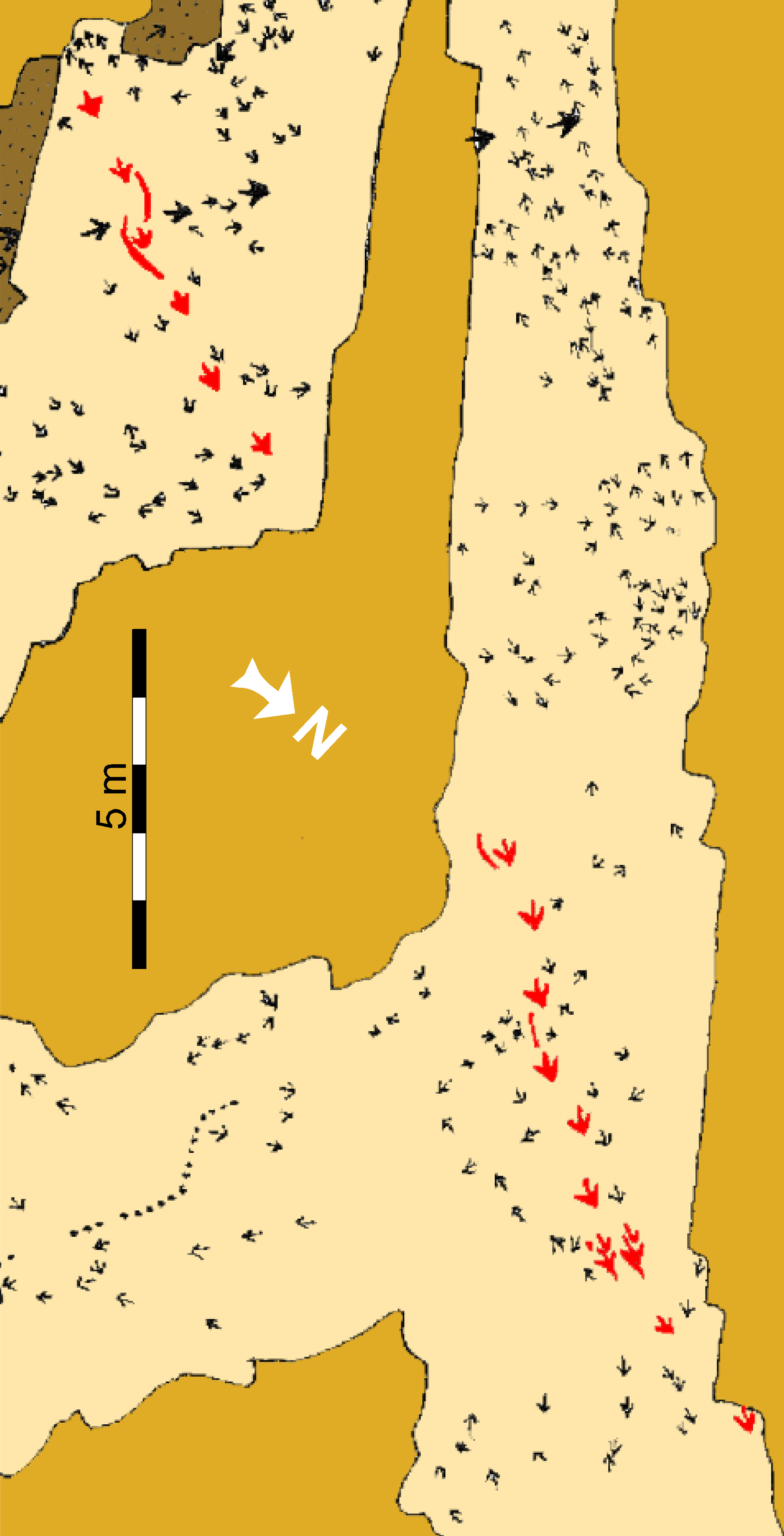
Schematic map of the “Top Surface” tracksite (SGDS.18). Beige shaded areas represent the “Top Surface” of the Main Track-bearing Sandstone Bed; gold shaded areas are unexcavated; brown areas represent areas removed after mapping to examine lower horizons. The Eubrontes trackway that includes the crouching trace is highlighted in red. |
||
| 日期 | |||
| 来源 | http://journals.plos.org/plosone/article?id=10.1371/journal.pone.0004591 | ||
| 作者 | Andrew R. C. Milner, Jerald D. Harris, Martin G. Lockley, James I. Kirkland, Neffra A. Matthews | ||
| 授权 (二次使用本文件) |
|
文件历史
点击某个日期/时间查看对应时刻的文件。
| 日期/时间 | 缩略图 | 大小 | 用户 | 备注 | |
|---|---|---|---|---|---|
| 当前 | 2020年11月8日 (日) 05:12 | | 1,967 × 3,853(942 KB) | FunkMonk(留言 | 贡献) | Turned as in source. |
| 2019年6月18日 (二) 04:36 |  | 3,853 × 1,967(847 KB) | FunkMonk(留言 | 贡献) | {{Information |Description=Schematic map of the “Top Surface” tracksite (SGDS.18). Beige shaded areas represent the “Top Surface” of the Main Track-bearing Sandstone Bed; gold shaded areas are unexcavated; brown areas represent areas removed after mapping to examine lower horizons. The Eubrontes trackway that includes the crouching trace is highlighted in red. |Source=http://journals.plos.org/plosone/article?id=10.1371/journal.pone.0004591 |Date=2009 |Author=Andrew R. C. Milner, Jerald D. Ha... |
您不可以覆盖此文件。
文件用途
没有页面使用本文件。
全域文件用途
以下其他wiki使用此文件:
- en.wikipedia.org上的用途
- zh.wikipedia.org上的用途
.png&oldid=708576180)