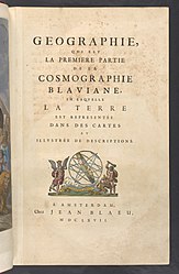
File:((Book 1 Norway)) - Atlas Maior, vol 1 - Joan Blaeu, 1667 - BL 114.h(star).1 - 115.jpg

Original file (2,477 × 4,000 pixels, file size: 1.07 MB, MIME type: image/jpeg)
Captions
Captions
Summary[edit]
| Description((Book 1 Norway)) - Atlas Maior, vol 1 - Joan Blaeu, 1667 - BL 114.h(star).1 - 115.jpg |
English: Page from the French version of Joan Blaeu's Atlas Maior, published 1667 |
| Date | |
| Source | British Library image release, see below |
| Author | Joan Blaeu |
| Joan Blaeu: Blaeu's Atlas Maior, Vol 1 (Northern Europe, Norway, and Denmark) - BL 114.h*.1
|
||||||||||||||||||||||||||||||||||
|---|---|---|---|---|---|---|---|---|---|---|---|---|---|---|---|---|---|---|---|---|---|---|---|---|---|---|---|---|---|---|---|---|---|---|
| Author |
|
|||||||||||||||||||||||||||||||||
| Title |
French: Blaeu's Atlas Maior, Vol 1 (Northern Europe, Norway, and Denmark) - BL 114.h*.1 title QS:P1476,fr:"Geographie, qvi est la Premiere Partie de la Cosmographie Blaviane, en laqvelle La Terre est representée dans des cartes et illvstrée de descriptions.
label QS:Lfr,"Geographie, qvi est la Premiere Partie de la Cosmographie Blaviane, en laqvelle La Terre est representée dans des cartes et illvstrée de descriptions.
label QS:Len,"Blaeu's Atlas Maior, Vol 1 (Northern Europe, Norway, and Denmark) - BL 114.h*.1" |
|||||||||||||||||||||||||||||||||
| Part of |
Blaeu's Atlas Maior (1667) BL 114.h*.1-12 |
|||||||||||||||||||||||||||||||||
| Publisher | ||||||||||||||||||||||||||||||||||
| Object type |
atlas / volume / individual copy of a book |
|||||||||||||||||||||||||||||||||
| Language |
French |
|||||||||||||||||||||||||||||||||
| Publication date |
1667 |
|||||||||||||||||||||||||||||||||
| Dimensions |
height: 55.5 cm (21.8 in) dimensions QS:P2048,+55.5U174728 dimensions QS:P2049,+36.5U174728 |
|||||||||||||||||||||||||||||||||
| Collection |
institution QS:P195,Q23308
|
|||||||||||||||||||||||||||||||||
| Accession number |
114.h*.1 (British Library) |
|||||||||||||||||||||||||||||||||
| Place of publication |
Amsterdam |
|||||||||||||||||||||||||||||||||
| Source |
Part of King George III's Topographical Collection. Donated to the nation by George IV. Please do not overwrite this file. Any cropped or modified version should be uploaded with a new name and linked in the "
|
|||||||||||||||||||||||||||||||||
| Other versions |
|
|||||||||||||||||||||||||||||||||
Licensing[edit]
| Public domainPublic domainfalsefalse |
|
This work is in the public domain in its country of origin and other countries and areas where the copyright term is the author's life plus 100 years or fewer. This work is in the public domain in the United States because it was published (or registered with the U.S. Copyright Office) before January 1, 1929. | |
| This file has been identified as being free of known restrictions under copyright law, including all related and neighboring rights. | |
https://creativecommons.org/publicdomain/mark/1.0/PDMCreative Commons Public Domain Mark 1.0falsefalse
File history
Click on a date/time to view the file as it appeared at that time.
| Date/Time | Thumbnail | Dimensions | User | Comment | |
|---|---|---|---|---|---|
| current | 14:44, 21 May 2019 |  | 2,477 × 4,000 (1.07 MB) | JhealdBot (talk | contribs) | JhealdBot(6) |
You cannot overwrite this file.
File usage on Commons
The following page uses this file:
Metadata
This file contains additional information such as Exif metadata which may have been added by the digital camera, scanner, or software program used to create or digitize it. If the file has been modified from its original state, some details such as the timestamp may not fully reflect those of the original file. The timestamp is only as accurate as the clock in the camera, and it may be completely wrong.
| Author | BOOK2NET |
|---|---|
| Copyright holder |
|
| Software used | Tocosa Copy Software Ver.:6.18 |
| File change date and time | 09:34, 8 February 2018 |
| Identifier | 114_h_1_115 |


