File:(A survey of a plot in Lancaster and Northumberland counties bounded by the Chesapeake Bay, Rappahnnock River, and the Potomac River ) LOC 2007627337.jpg
Jump to navigation
Jump to search

Size of this preview: 489 × 600 pixels. Other resolutions: 196 × 240 pixels | 391 × 480 pixels | 626 × 768 pixels | 835 × 1,024 pixels | 1,670 × 2,048 pixels | 6,774 × 8,305 pixels.
Original file (6,774 × 8,305 pixels, file size: 7.09 MB, MIME type: image/jpeg)
Captions
Captions
Add a one-line explanation of what this file represents
Summary[edit]
| Description |
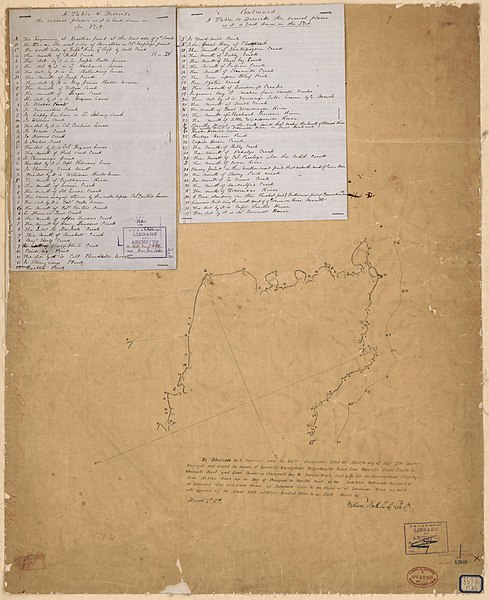
English: Relief shown by hachures. Cadastral survey map. Title devised by cataloger. Pen-and-ink on tracing paper, mounted on cloth with an index of place names and resident houses on 2 sheets of blue lined paper attached. Oriented with north toward the lower left. In ink in top right margin: 11-D crossed out. Along edges in faint red crayon: 1736 Chesapeake Bay, Rappahannock River, and Potomac River. Map stamped in lower right corner: U.S.C. & G. Survey. Library and Archives no. 376; map stamped in lower right corner U.S.C. & G. Survey. Library and Archives no. 1360 (in blue ink); handwritten no. in ink on blue bordered label in lower right corner: 863R 1736. Includes notes. Imperfect: Wrinkles and liquid staining throughout. Some losses along edges. Available also through the Library of Congress Web site as a raster image. |
||
| Title | [A survey of a plot in Lancaster and Northumberland counties bounded by the Chesapeake Bay, Rappahnnock River, and the Potomac River ] | ||
| Shelf ID | G3883.L3 1736 .B2 | ||
| Date | |||
| Source | https://www.loc.gov/item/2007627337/ | ||
| Author | Ball, William | ||
| Permission (Reusing this file) |
|
||
| Other versions |
|
||
| Location | Northumberland County · Lancaster County · Virginia · United States | ||
| Part of | American Memory · Catalog · County Landownership Maps · Geography And Map Division · Cultural Landscapes | ||
| Subject | Maps, Manuscript · Northumberland County (Va.) · Lancaster County (Va.) · Maps · Virginia · Northumberland County · Lancaster County · Early Works To 1800 · Real Property · Surveys · United States |


_LOC_2007627337.jpg&action=edit§ion=1)
Licensing[edit]
_LOC_2007627337.jpg&action=edit§ion=2)
|
This is a faithful photographic reproduction of a two-dimensional, public domain work of art. The work of art itself is in the public domain for the following reason:
The official position taken by the Wikimedia Foundation is that "faithful reproductions of two-dimensional public domain works of art are public domain".
This photographic reproduction is therefore also considered to be in the public domain in the United States. In other jurisdictions, re-use of this content may be restricted; see Reuse of PD-Art photographs for details. | ||||
File history
Click on a date/time to view the file as it appeared at that time.
| Date/Time | Thumbnail | Dimensions | User | Comment | |
|---|---|---|---|---|---|
| current | 15:03, 10 June 2018 | | 6,774 × 8,305 (7.09 MB) | Fæ (talk | contribs) | LOC Maps https://www.loc.gov/item/2007627337/ #10924 |
You cannot overwrite this file.
File usage on Commons
The following page uses this file:
_LOC_2007627337.jpg&oldid=733908234)