File:(Savannah River & Ogeechee River). LOC 73691564.jpg
Jump to navigation
Jump to search
Size of this preview: 702 × 599 pixels. Other resolutions: 281 × 240 pixels | 562 × 480 pixels | 900 × 768 pixels | 1,199 × 1,024 pixels | 2,399 × 2,048 pixels | 4,336 × 3,702 pixels.
Original file (4,336 × 3,702 pixels, file size: 2.37 MB, MIME type: image/jpeg)
Captions
Captions
Add a one-line explanation of what this file represents
Summary
[edit]| Description |
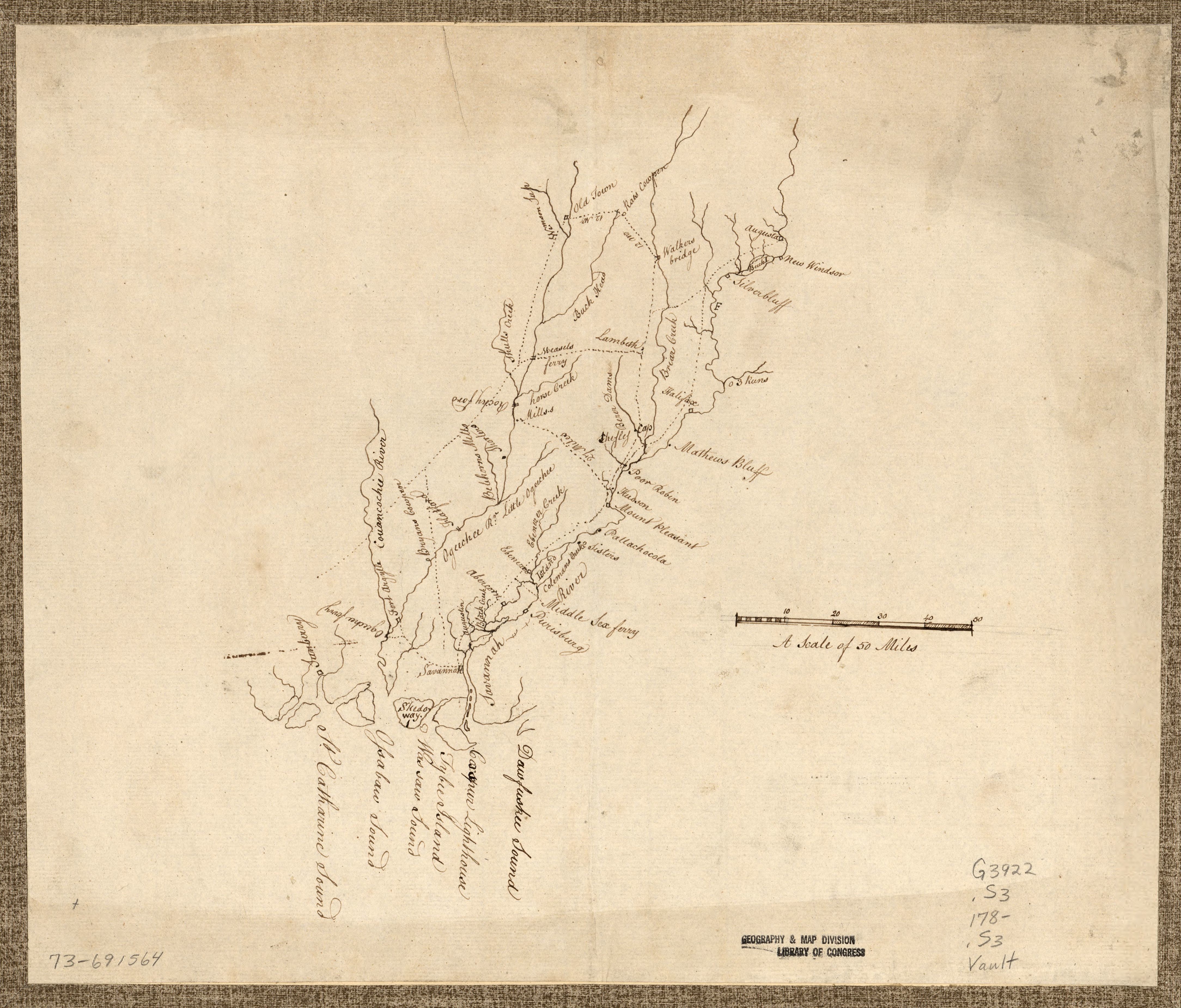
English: Shows the Savannah River from the Georgia coast north to Augusta and the Ogeechee River from the coast north to "Old Town." Title and date from Peter Force map collection checklist. Oriented with north towards the upper right. Pen and ink and pencil. Mounted on paper. Available also through the Library of Congress Web site as a raster image. Indicates towns and roads. |
||
| Title | [Savannah River & Ogeechee River]. | ||
| Shelf ID | G3922.S3 178- .S3 | ||
| Date | |||
| Source | https://www.loc.gov/item/73691564/ | ||
| Author | Unknown author | ||
| Permission (Reusing this file) |
|
||
| Other versions |
|
||
| Location | Savannah River · South Carolina · Ogeechee River · Georgia · United States | ||
| Part of | Military Battles And Campaigns · American Memory · Catalog · Geography And Map Division · American Revolution And Its Era: Maps And Charts Of North America And The West Indies, 1750-1789 | ||
| Subject | Savannah River · Ogeechee River (Ga.) · Georgia · Early Maps · Savannah River (Ga. And S.C.) · United States · Maps · Early Works To 1800 · South Carolina · Ogeechee River · Manuscript Maps |


._LOC_73691564.jpg&action=edit§ion=1)
Licensing
[edit]._LOC_73691564.jpg&action=edit§ion=2)
|
This is a faithful photographic reproduction of a two-dimensional, public domain work of art. The work of art itself is in the public domain for the following reason:
The official position taken by the Wikimedia Foundation is that "faithful reproductions of two-dimensional public domain works of art are public domain".
This photographic reproduction is therefore also considered to be in the public domain in the United States. In other jurisdictions, re-use of this content may be restricted; see Reuse of PD-Art photographs for details. | ||||
File history
Click on a date/time to view the file as it appeared at that time.
| Date/Time | Thumbnail | Dimensions | User | Comment | |
|---|---|---|---|---|---|
| current | 09:27, 1 December 2018 | | 4,336 × 3,702 (2.37 MB) | Fæ (talk | contribs) | LOC Maps https://www.loc.gov/item/73691564/ #6282 |
You cannot overwrite this file.
File usage on Commons
The following page uses this file:
._LOC_73691564.jpg&oldid=745690827)