File:11-09-fotofluege-cux-allg-25a.jpg
Zur Navigation springen
Zur Suche springen

Greßi vu däre Vorschau: 600 × 600 Pixel. Wyteri Ufflösige: 240 × 240 Pixel | 480 × 480 Pixel | 768 × 768 Pixel | 1.024 × 1.024 Pixel | 2.048 × 2.048 Pixel | 2.848 × 2.848 Pixel.
Originaldatei (2.848 × 2.848 Pixel, Dateigrößi: 5,53 MB, MIME-Typ: image/jpeg)
Bildtexte
Kurzbeschreibungen
Ergänze eine einzeilige Erklärung, was diese Datei darstellt.
Bschryybig[ändere]
| Bschryybig |
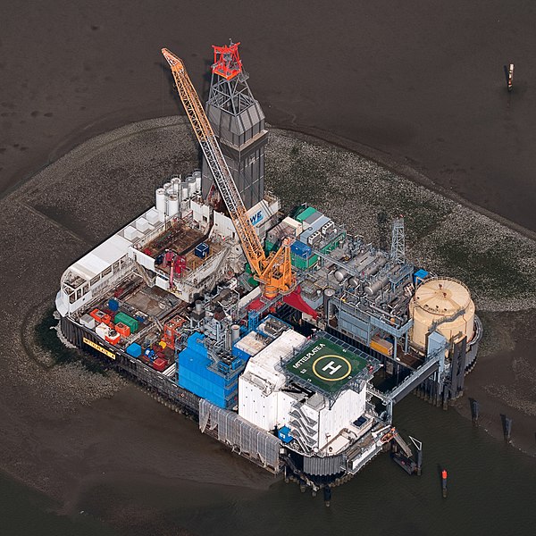
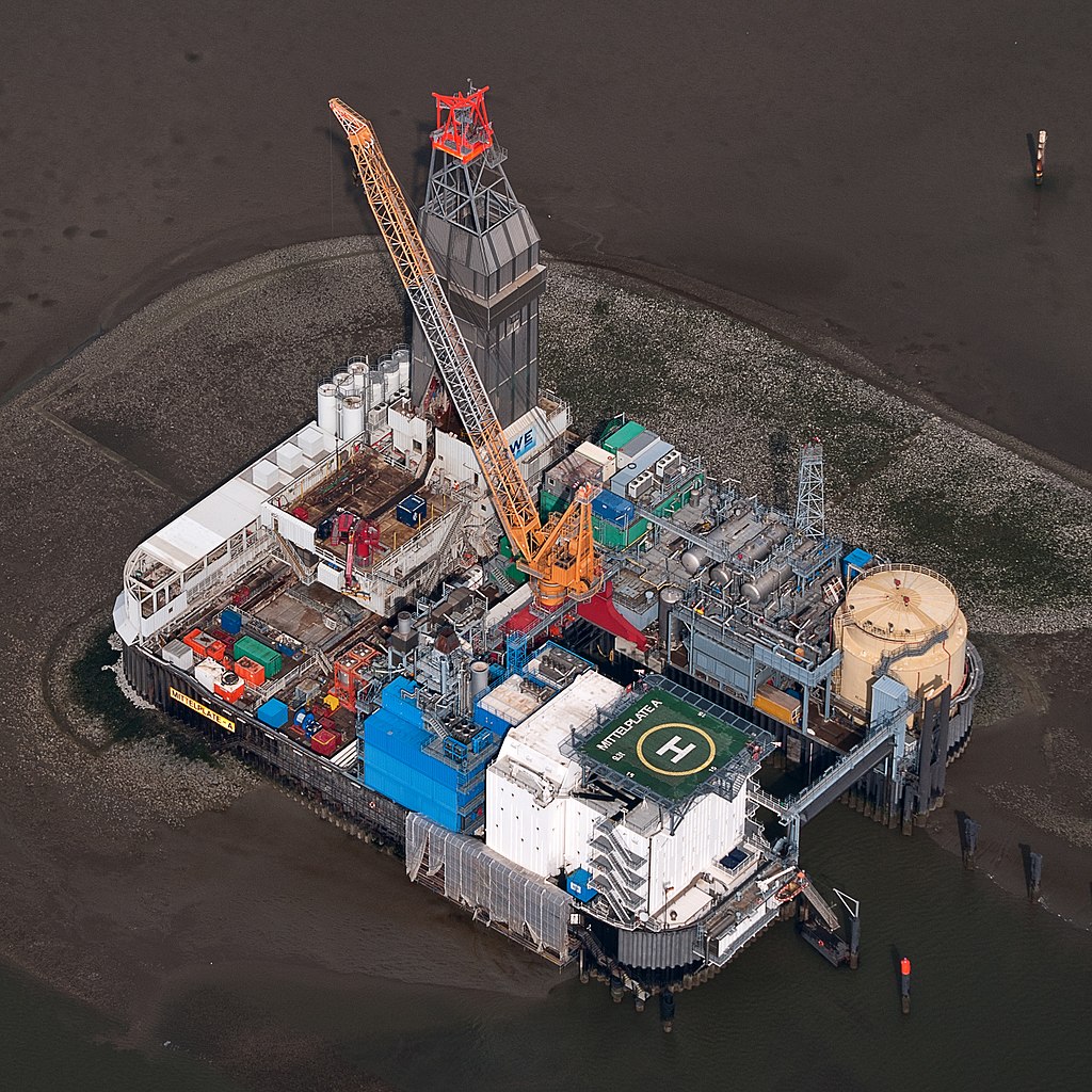
Deutsch: Fotoflug Nordsee; Ölbohrinsel im Ölfeld Mittelplate
English: Germany’s largest oil field Mittelplate
Español: Vista aérea de la plataforma petrolera de Mittelplate, el mayor yacimiento petrolífero de Alemania.
Français : Vue aérienne de Mittelplate, le plus grand champ pétrolifère d'Allemagne
Polski: Platforma wiertnicza na największym niemieckim polu naftowym „Mittelplate” znajdującym się na Morzu Północnym.
Português: Vista aérea da plataforma petrolífera de Mittelplate, o maior campo de petróleo da Alemanha. |
|||||||||||||||||||||||
| Datum | ||||||||||||||||||||||||
| Quälle | Eigeni Arbet | |||||||||||||||||||||||
| Urheber |
|
|||||||||||||||||||||||
| Gnähmigung (Wyternutzig vu däre Datei) |
|
|||||||||||||||||||||||
| Anderi Versione |
 |
|||||||||||||||||||||||

| Kameraposition | | Dieses und weitere Bilder auf OpenStreetMap |
|---|
Auszeichnungen[ändere]
|
This image was selected as picture of the day on Wikimedia Commons for 2 February 2016. It was captioned as follows: English: Germany’s largest oil field Mittelplate Other languages:
Bosanski: Najveće naftno polje u Njemačkoj, Mittelplate Català: Mittelplate, el camp petrolier més gran d'Alemanya. Deutsch: Fotoflug Nordsee; Ölbohrinsel im Ölfeld Mittelplate English: Germany’s largest oil field Mittelplate Español: Vista aérea de la plataforma petrolera de Mittelplate, el mayor yacimiento petrolífero de Alemania. Italiano: Vista aerea della piattaforma petrolifera di Mittelplate, il principale giacimento petrolifero tedesco. Português: Vista aérea da plataforma petrolífera de Mittelplate, o maior campo de petróleo da Alemanha. Suomi: Mittelplate, suurin öljykentän Saksan. Македонски: Мителплате — најголемото нафтено поле во Германија. Русский: Миттельплате, крупнейшее месторождение нефти Германии. 한국어: 독일에서 가장 큰 유전 미텔플라테. 中文: 德国最大油井 Mittelplate 中文(繁體): 德國最大油井 Mittelplate |
Lizänzierig[ändere]
| Dieses Foto entstand aufgrund eines Projektes, das von Wikimedia Deutschland e. V. gefördert wurde.
Im Rahmen des „Community-Projektbudgets“ sollen Luftbilder u.a. von Inseln, Halligen, Sanden und Küstenorten der deutschen Nordseeküste angefertigt werden. Das Projekt „Fotoflüge“ wurde im September 2011 begonnen. |
Die Datei isch lizänziert unter dr Creative-Commons-Lizänz Namensnännig – Wytergab unter glyyche Bedingige 3.0 Dytschland.
- Du derfsch:
- des Wärch an anderi wytergee – des Wärch kopiere, verbreite un ibertrage
- des Wärch verändere – des Wärch aapasse
- Unter däne Bedingige:
- Namenännig – Du muesch aagmässeni Aagabe zum Urheber un dr Rächt mache, e Link zue dr Lizänz zuefiege un aagee, eb Änderige gmacht wore sin. Die Aagabe chenne in ere aagmässene Art gmacht wäre, aber nit eso, ass dr Yydruck entstoht, ass dr Lizänzgeber Dii oder Dyy Gebruch vum Wärch unterstitze un guetheiße.
- Wytergab unter glyche Bedingige – Wänn du des Wärch veränderesch, umwandlesch oder druf ufböusch, no derfsch s Ergebnis nume unter dr glyche oder ere kumpatible Lizänz wie s Orginal vereffetlige.

Dateiversione
Klick uf e Zytpunkt zu aazeige, wie s dert usgsäh het.
| Version vom | Vorschaubild | Mäß | Benutzer | Kommentar | |
|---|---|---|---|---|---|
| aktuell | 20:40, 13. Jan. 2015 | | 2.848 × 2.848 (5,53 MB) | Ralf Roletschek (Diskussion | Byträg) | volle Auflösung aus Original |
| 17:13, 28. Feb. 2013 |  | 2.848 × 2.848 (3,94 MB) | Jkadavoor (Diskussion | Byträg) | Reverted to version as of 21:23, 4 September 2011 per Commons:Overwriting_existing_files#DO_NOT_overwrite : Files that have been awarded a special status like Commons Featured Picture, or similar status on another Wikimedia project. Such files are ... | |
| 15:32, 21. Feb. 2013 |  | 5.932 × 5.932 (14,62 MB) | Ralf Roletschek (Diskussion | Byträg) | größere Version | |
| 21:23, 4. Sep. 2011 |  | 2.848 × 2.848 (3,94 MB) | Ralf Roletschek (Diskussion | Byträg) | {{Information |Description=Fotoflug Nordsee |Source={{own}} |Date=2011-09-04 |Author=Ralf Roletschek (<span class="signature-talk">talk</span>) |Permission= |other_versions=[[File:11-09-fotofluege-cux |
Du chasch die Datei nit iberschryybe.
Verwändig vu dr Datei
Die 42 Syte bruuche die Datei:
- Drilling rig
- Oil platform
- User:Ralf Roletschek/gallery/2011-Fotoflug1
- Commons:Featured picture candidates/File:11-09-fotofluege-cux-allg-25a.jpg
- Commons:Featured picture candidates/Log/June 2012
- Commons:Featured picture candidates/Log/March 2013
- Commons:Featured picture candidates/removal/File:11-09-fotofluege-cux-allg-25a.jpg
- Commons:Featured pictures/Places/Industry
- Commons:Featured pictures/chronological/2012-A
- Commons:Picture of the Year/2012/Galleries/2012-A
- Commons:Picture of the Year/2012/Galleries/ALL
- Commons:Picture of the Year/2012/Galleries/Constructions and buildings
- Commons:Picture of the Year/2012/Galleries/Index/10
- Commons:Picture of the Year/2012/Galleries/JUN
- Commons:Picture of the Year/2012/R1/11-09-fotofluege-cux-allg-25a.jpg
- Commons:Picture of the Year/2012/Results/R1/ALL
- Commons:Picture of the Year/2012/Results/R1/ALL/gallery
- Commons:Picture of the Year/2012/Results/R1/ALL/thumbnailtable
- Commons:Picture of the Year/2012/Results/R1/Constructions and buildings
- Commons:Picture of the Year/2013/R1/Test page
- Commons:Quality images/Subject/Places/Man made structures/Buildings, Exterior/Part 2
- Commons:Quality images candidates/Archives September 2011
- Commons:Village pump/Archive/2013/07
- Commons talk:Quality images/Subject/Places/Man made structures
- File:11-09-fotofluege-cux-allg-25.jpg
- Template:Potd/2016-02
- Template:Potd/2016-02-02
- Template:Potd/2016-02-02 (bs)
- Template:Potd/2016-02-02 (cs)
- Template:Potd/2016-02-02 (de)
- Template:Potd/2016-02-02 (en)
- Template:Potd/2016-02-02 (es)
- Template:Potd/2016-02-02 (hu)
- Template:Potd/2016-02-02 (it)
- Template:Potd/2016-02-02 (ko)
- Template:Potd/2016-02-02 (mk)
- Template:Potd/2016-02-02 (nl)
- Template:Potd/2016-02-02 (pt)
- Template:Potd/2016-02-02 (zh-hans)
- Template:Potd/2016-02-02 (zh-hant)
- Category:Mittelplate
- Category:Petroleum engineering
Wältwyti Dateinutzig
Die andere Wikis bruche die Datei:
- Gebruch uf ar.wikipedia.org
- Gebruch uf ar.wikinews.org
- Gebruch uf be-tarask.wikipedia.org
- Gebruch uf bg.wikipedia.org
- Gebruch uf ca.wikipedia.org
- Gebruch uf ceb.wikipedia.org
- Gebruch uf crh.wikipedia.org
- Gebruch uf cs.wikipedia.org
- Gebruch uf cv.wikipedia.org
- Gebruch uf da.wikipedia.org
- Gebruch uf de.wikipedia.org
- Wattenmeer (Nordsee)
- Erdöl
- Luftbildfotografie
- Bohrinsel
- Erdölförderung in Deutschland
- Mittelplate (Ölfeld)
- Friedrichskoog
- Nordseeöl
- Recht am Bild der eigenen Sache
- Wikipedia:Projekt Fotoflüge/2011/September
- Wikipedia:Projekt Fotoflüge/Ergebnisse
- Wikipedia Diskussion:Projekt Fotoflugkurs Cuxhaven 2013
- Wikipedia:AdminConvention 2016/Teilnehmer
- Benutzer:Artikelstube/Liste von Bauverfahren
- Gebruch uf de.wikiversity.org
- Gebruch uf de.wikivoyage.org
- Gebruch uf el.wikipedia.org
- Gebruch uf en.wikipedia.org
- Oil platform
- North Sea oil
- Wikipedia:WikiProject Energy
- Mittelplate
- Wikipedia:Featured pictures/Places/Architecture
- Marine architecture
- User talk:Ralf Roletschek
- User talk:Nikhil B
- Wikipedia:WikiProject Energy/Recognized content
- Portal:Energy/Explore/Recognized content
- Accommodation platform
- Wikipedia:Featured pictures thumbs/59
- Wikipedia:Featured picture candidates/November-2016
- Wikipedia:Featured picture candidates/Mittelplate
- Wikipedia:Wikipedia Signpost/2016-11-26/Featured content
- Wikipedia:Wikipedia Signpost/Single/2016-11-26
Wältwyti Verwändig vu däre Datei aaluege.