File:11-09-fotofluege-cux-allg-25a.jpg
ナビゲーションに移動
検索に移動

このプレビューのサイズ: 600 × 600 ピクセル。 その他の解像度: 240 × 240 ピクセル | 480 × 480 ピクセル | 768 × 768 ピクセル | 1,024 × 1,024 ピクセル | 2,048 × 2,048 ピクセル | 2,848 × 2,848 ピクセル。
元のファイル (2,848 × 2,848 ピクセル、ファイルサイズ: 5.53メガバイト、MIME タイプ: image/jpeg)
キャプション
キャプション
このファイルの内容を1行で記述してください
概要
[編集]| 解説 |
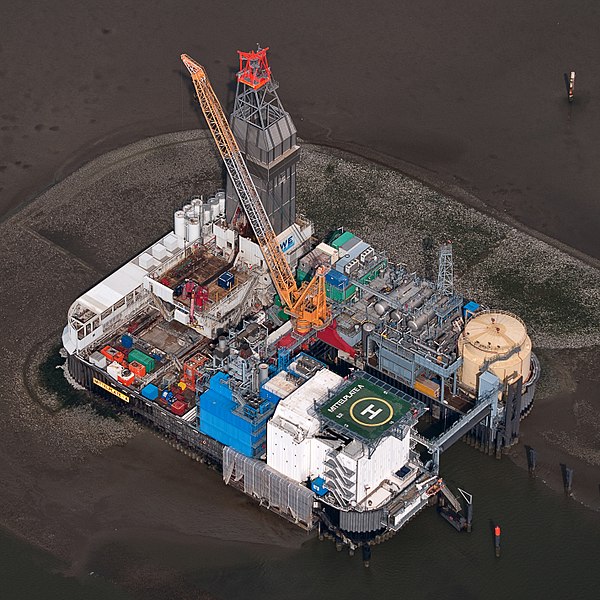
Deutsch: Fotoflug Nordsee; Ölbohrinsel im Ölfeld Mittelplate
English: Germany’s largest oil field Mittelplate
Español: Vista aérea de la plataforma petrolera de Mittelplate, el mayor yacimiento petrolífero de Alemania.
Français : Vue aérienne de Mittelplate, le plus grand champ pétrolifère d'Allemagne
Polski: Platforma wiertnicza na największym niemieckim polu naftowym „Mittelplate” znajdującym się na Morzu Północnym.
Português: Vista aérea da plataforma petrolífera de Mittelplate, o maior campo de petróleo da Alemanha. |
|||||||||||||||||||||||
| 日付 | ||||||||||||||||||||||||
| 原典 | 投稿者自身による著作物 | |||||||||||||||||||||||
| 作者 |
|
|||||||||||||||||||||||
| 許可 (ファイルの再利用) |
|
|||||||||||||||||||||||
| その他のバージョン |
 |
|||||||||||||||||||||||

| カメラの位置 | | 以下のサービスでこの位置を確認する: オープンストリートマップ |
|---|
評価
[編集]
|
English: Germany’s largest oil field Mittelplate 他の言語
Bosanski: Najveće naftno polje u Njemačkoj, Mittelplate Català: Mittelplate, el camp petrolier més gran d'Alemanya. Deutsch: Fotoflug Nordsee; Ölbohrinsel im Ölfeld Mittelplate English: Germany’s largest oil field Mittelplate Español: Vista aérea de la plataforma petrolera de Mittelplate, el mayor yacimiento petrolífero de Alemania. Italiano: Vista aerea della piattaforma petrolifera di Mittelplate, il principale giacimento petrolifero tedesco. Português: Vista aérea da plataforma petrolífera de Mittelplate, o maior campo de petróleo da Alemanha. Suomi: Mittelplate, suurin öljykentän Saksan. Македонски: Мителплате — најголемото нафтено поле во Германија. Русский: Миттельплате, крупнейшее месторождение нефти Германии. 한국어: 독일에서 가장 큰 유전 미텔플라테. 中文: 德国最大油井 Mittelplate 中文(繁體): 德國最大油井 Mittelplate |
ライセンス
[編集]
| Dieses Foto entstand aufgrund eines Projektes, das von Wikimedia Deutschland e. V. gefördert wurde.
Im Rahmen des „Community-Projektbudgets“ sollen Luftbilder u.a. von Inseln, Halligen, Sanden und Küstenorten der deutschen Nordseeküste angefertigt werden. Das Projekt „Fotoflüge“ wurde im September 2011 begonnen. |
このファイルはクリエイティブ・コモンズ 表示-継承 3.0 ドイツライセンスのもとに利用を許諾されています。
- あなたは以下の条件に従う場合に限り、自由に
- 共有 – 本作品を複製、頒布、展示、実演できます。
- 再構成 – 二次的著作物を作成できます。
- あなたの従うべき条件は以下の通りです。
- 表示 – あなたは適切なクレジットを表示し、ライセンスへのリンクを提供し、変更があったらその旨を示さなければなりません。これらは合理的であればどのような方法で行っても構いませんが、許諾者があなたやあなたの利用行為を支持していると示唆するような方法は除きます。
- 継承 – もしあなたがこの作品をリミックスしたり、改変したり、加工した場合には、あなたはあなたの貢献部分を元の作品とこれと同一または互換性があるライセンスの下に頒布しなければなりません。

ファイルの履歴
過去の版のファイルを表示するには、その版の日時をクリックしてください。
| 日付と時刻 | サムネイル | 寸法 | 利用者 | コメント | |
|---|---|---|---|---|---|
| 現在の版 | 2015年1月13日 (火) 20:40 | | 2,848 × 2,848(5.53メガバイト) | Ralf Roletschek(トーク | 投稿記録) | volle Auflösung aus Original |
| 2013年2月28日 (木) 17:13 |  | 2,848 × 2,848(3.94メガバイト) | Jkadavoor(トーク | 投稿記録) | Reverted to version as of 21:23, 4 September 2011 per Commons:Overwriting_existing_files#DO_NOT_overwrite : Files that have been awarded a special status like Commons Featured Picture, or similar status on another Wikimedia project. Such files are ... | |
| 2013年2月21日 (木) 15:32 |  | 5,932 × 5,932(14.62メガバイト) | Ralf Roletschek(トーク | 投稿記録) | größere Version | |
| 2011年9月4日 (日) 21:23 |  | 2,848 × 2,848(3.94メガバイト) | Ralf Roletschek(トーク | 投稿記録) | {{Information |Description=Fotoflug Nordsee |Source={{own}} |Date=2011-09-04 |Author=Ralf Roletschek (<span class="signature-talk">talk</span>) |Permission= |other_versions=[[File:11-09-fotofluege-cux |
このファイルは上書きできません。
ファイルの使用状況
以下の 42 ページがこのファイルを使用しています:
- Drilling rig
- Oil platform
- User:Ralf Roletschek/gallery/2011-Fotoflug1
- Commons:Featured picture candidates/File:11-09-fotofluege-cux-allg-25a.jpg
- Commons:Featured picture candidates/Log/June 2012
- Commons:Featured picture candidates/Log/March 2013
- Commons:Featured picture candidates/removal/File:11-09-fotofluege-cux-allg-25a.jpg
- Commons:Featured pictures/Places/Industry
- Commons:Featured pictures/chronological/2012-A
- Commons:Picture of the Year/2012/Galleries/2012-A
- Commons:Picture of the Year/2012/Galleries/ALL
- Commons:Picture of the Year/2012/Galleries/Constructions and buildings
- Commons:Picture of the Year/2012/Galleries/Index/10
- Commons:Picture of the Year/2012/Galleries/JUN
- Commons:Picture of the Year/2012/R1/11-09-fotofluege-cux-allg-25a.jpg
- Commons:Picture of the Year/2012/Results/R1/ALL
- Commons:Picture of the Year/2012/Results/R1/ALL/gallery
- Commons:Picture of the Year/2012/Results/R1/ALL/thumbnailtable
- Commons:Picture of the Year/2012/Results/R1/Constructions and buildings
- Commons:Picture of the Year/2013/R1/Test page
- Commons:Quality images/Subject/Places/Man made structures/Buildings, Exterior/Part 2
- Commons:Quality images candidates/Archives September 2011
- Commons:Village pump/Archive/2013/07
- Commons talk:Quality images/Subject/Places/Man made structures
- File:11-09-fotofluege-cux-allg-25.jpg
- Template:Potd/2016-02
- Template:Potd/2016-02-02
- Template:Potd/2016-02-02 (bs)
- Template:Potd/2016-02-02 (cs)
- Template:Potd/2016-02-02 (de)
- Template:Potd/2016-02-02 (en)
- Template:Potd/2016-02-02 (es)
- Template:Potd/2016-02-02 (hu)
- Template:Potd/2016-02-02 (it)
- Template:Potd/2016-02-02 (ko)
- Template:Potd/2016-02-02 (mk)
- Template:Potd/2016-02-02 (nl)
- Template:Potd/2016-02-02 (pt)
- Template:Potd/2016-02-02 (zh-hans)
- Template:Potd/2016-02-02 (zh-hant)
- Category:Mittelplate
- Category:Petroleum engineering
グローバルなファイル使用状況
以下に挙げる他のウィキがこの画像を使っています:
- ar.wikipedia.org での使用状況
- ar.wikinews.org での使用状況
- be-tarask.wikipedia.org での使用状況
- bg.wikipedia.org での使用状況
- ca.wikipedia.org での使用状況
- ceb.wikipedia.org での使用状況
- crh.wikipedia.org での使用状況
- cs.wikipedia.org での使用状況
- cv.wikipedia.org での使用状況
- da.wikipedia.org での使用状況
- de.wikipedia.org での使用状況
- Wattenmeer (Nordsee)
- Erdöl
- Luftbildfotografie
- Bohrinsel
- Erdölförderung in Deutschland
- Mittelplate (Ölfeld)
- Friedrichskoog
- Nordseeöl
- Recht am Bild der eigenen Sache
- Wikipedia:Projekt Fotoflüge/2011/September
- Wikipedia:Projekt Fotoflüge/Ergebnisse
- Wikipedia Diskussion:Projekt Fotoflugkurs Cuxhaven 2013
- Wikipedia:AdminConvention 2016/Teilnehmer
- Benutzer:Artikelstube/Liste von Bauverfahren
- de.wikiversity.org での使用状況
- de.wikivoyage.org での使用状況
- el.wikipedia.org での使用状況
- en.wikipedia.org での使用状況
- Oil platform
- North Sea oil
- Wikipedia:WikiProject Energy
- Mittelplate
- Wikipedia:Featured pictures/Places/Architecture
- Marine architecture
- User talk:Ralf Roletschek
- User talk:Nikhil B
- Wikipedia:WikiProject Energy/Recognized content
- Portal:Energy/Explore/Recognized content
- Accommodation platform
- Wikipedia:Featured pictures thumbs/59
- Wikipedia:Featured picture candidates/November-2016
- Wikipedia:Featured picture candidates/Mittelplate
- Wikipedia:Wikipedia Signpost/2016-11-26/Featured content
- Wikipedia:Wikipedia Signpost/Single/2016-11-26
このファイルのグローバル使用状況を表示する。