File:13-09-29-nordfriesisches-wattenmeer-RalfR-15.jpg
跳转到导航
跳转到搜索

本预览的尺寸:800 × 531像素。 其他分辨率:320 × 213像素 | 640 × 425像素 | 1,024 × 680像素 | 1,280 × 850像素 | 2,560 × 1,700像素 | 4,288 × 2,848像素。
原始文件 (4,288 × 2,848像素,文件大小:5.75 MB,MIME类型:image/jpeg)
说明
说明
添加一行文字以描述该文件所表现的内容
摘要
[编辑]
| 描述 |
Català: Neuwerk illa al Mar de Wadden al Mar del Nord, Alemanya
Čeština: Neuwerk ostrov v moři Wadden do Severního moře, Německo
Dansk: Neuwerk ø i Vadehavet til Vesterhavet, Tyskland
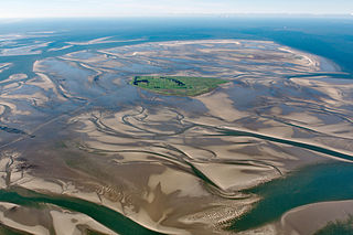
Deutsch: Fotoflug über das nordfriesische Wattenmeer; Blick von OSO aus 1,4 km Höhe und 6 km Entfernung auf Neuwerk. Links sind die Pferdefuhrwerke im Watt erkennbar.
English: Island Neuwerk near Hamburg in the German Wadden Sea. View from ESE, from 1400 m height and 6 km distance.
Español: Neuwerk isla en el Mar de Wadden en el Mar del Norte, Alemania
Suomi: Neuwerk saari Waddenzeen Pohjanmeren, Saksa
Русский: Ваттовое море у берегов Германии. Зелёный остров Нойверк с маяком (1369), за ним остров Шархёрн - птичий заповедник.
Українська: Ваттове море біля берегів Німеччини. Зелений острів Нойверк з маяком (1369), за ним острів Шархьорн - пташиний заповідник. |
|||||||||||||||||||||||
| 日期 | ||||||||||||||||||||||||
| 来源 | 自己的作品 | |||||||||||||||||||||||
| 作者 |
|
|||||||||||||||||||||||
| 其他版本 | ||||||||||||||||||||||||
| 相机位置 | | 在以下服务上查看本图像和附近其他图像: OpenStreetMap |
|---|
|
本图像被选为2014年3月24日的今日图片。其说明如下: English: Island Neuwerk near Hamburg in the german wadden Sea; View from ESE and a high of 4600 feet and distance of 20.000 feet. 其他语言:
Bosanski: Ostrvo Neuwerk blizu Hamburga na njemačkoj obali Sjevernog mora (Wattensee); Pogled iz pravca istok-sjeveroistok sa visine 1.400 metara i udaljenosti 6.000 metara. English: Island Neuwerk near Hamburg in the german wadden Sea; View from ESE and a high of 4600 feet and distance of 20.000 feet. Italiano: Isola di Neuwerk vicino ad Amburgo nel mare dei Wadden; Vista da ESE da un'altezza di 1,5 km e una distanza di 6 km. Magyar: Neuwerk sziget Hamburg közelében a német Watt-tengeren kelet-délkelet felől nézve, 4600 láb (1,4 km) magasból és 20 000 láb (6,1 km) távolságból Nederlands: Het Waddeneiland Neuwerk bij Cuxhaven in het Duitse gedeelte van de Waddenzee, gezien vanaf een hoogte van 4600 voet en een afstand van 20.000 voet. 한국어: 독일 바덴 해, 함부르크 근교의 노이베르크 섬. 동남동 방향에서 고도 4600 피트, 거리 20000 피트에서 촬영. 中文: 瓦登海诺伊韦克岛。 |
许可协议
[编辑]
我,本作品著作权人,特此采用以下许可协议发表本作品:

|
已授权您依据自由软件基金会发行的无固定段落及封面封底文字(Invariant Sections, Front-Cover Texts, and Back-Cover Texts)的GNU自由文件许可协议1.2版或任意后续版本的条款,复制、传播和/或修改本文件。该协议的副本请见“GNU Free Documentation License”。 |
- 您可以自由地:
- 共享 – 复制、发行并传播本作品
- 修改 – 改编作品
- 惟须遵守下列条件:
- 署名 – 您必须对作品进行署名,提供授权条款的链接,并说明是否对原始内容进行了更改。您可以用任何合理的方式来署名,但不得以任何方式表明许可人认可您或您的使用。
- 相同方式共享 – 如果您再混合、转换或者基于本作品进行创作,您必须以与原先许可协议相同或相兼容的许可协议分发您贡献的作品。
您可以选择您需要的许可协议。

- Weiternutzung dieses Fotos
- Wenn Sie dieses Foto im Internet verwenden möchten, bitte ich um Verlinkung meiner privaten Homepage: www.fahrradmonteur.de.
Sie können das Bild unter einer der unten angegebenen Lizenzen frei verwenden, dabei ist keine Gebühr zu entrichten. Eine kommerzielle Verwendung dieses Fotos ist ebenfalls möglich, dabei sind außer den u. g. Lizenzbestimmungen keine gesonderten Bedingungen zu beachten.
| Ralf Roletschek
(1963–) |
|||
|---|---|---|---|
 |
|||
| 描述 | 德国土木工程師和攝影師 | ||
| 出生日期 |
1963年 | ||
| 出生地点 | 埃伯斯瓦尔德 | ||
| 工作时期 | 自1979年 | ||
| 工作地点 |
Barcelona, Wien, Eberswalde | ||
| 權威控制 | |||
| Dieses Foto entstand aufgrund eines Projektes, das von Wikimedia Deutschland e. V. gefördert wurde.
Im Rahmen des „Community-Projektbudgets“ sollen Luftbilder u.a. von Inseln, Halligen, Sanden und Küstenstädten der deutschen Nordseeküste angefertigt werden. Das Projekt „Fotoflüge“ wurde im September 2011 begonnen. |
| 註解 | 該圖片含有註解:在維基媒體共享資源上查看註解 |
文件历史
点击某个日期/时间查看对应时刻的文件。
| 日期/时间 | 缩略图 | 大小 | 用户 | 备注 | |
|---|---|---|---|---|---|
| 当前 | 2013年10月14日 (一) 09:38 | | 4,288 × 2,848(5.75 MB) | Ralf Roletschek(留言 | 贡献) | leicht gedreht, CA gemildert |
| 2013年10月4日 (五) 10:14 |  | 4,288 × 2,848(3.38 MB) | Ralf Roletschek(留言 | 贡献) |
您不可以覆盖此文件。
文件用途
以下39个页面使用本文件:
- Hamburg
- User:Dontworry/images part 6
- User:Miya/sandbox/FP/2013/Galleries/Table
- User:Ralf Roletschek/Bücher
- User:Ralf Roletschek/Bücher/2015
- User:Ralf Roletschek/Bücher/2016
- User:Ralf Roletschek/Bücher/2018
- User:Ralf Roletschek/Nordfriesische Inseln
- User:Ralf Roletschek/gallery/2013-3
- User:Zyephyrus/2014
- User:Zyephyrus/2014/10
- User talk:Ralf Roletschek/Archive/2013
- Commons:Featured picture candidates/File:13-09-29-nordfriesisches-wattenmeer-RalfR-15.jpg
- Commons:Featured picture candidates/Log/October 2013
- Commons:Featured pictures/Places/Settlements
- Commons:Featured pictures/chronological/2013-B
- Commons:Picture of the Year/2013/Candidates
- Commons:Picture of the Year/2013/Galleries/Table
- Commons:Picture of the Year/2013/R1/Gallery/2013-B
- Commons:Picture of the Year/2013/R1/Gallery/ALL
- Commons:Picture of the Year/2013/R1/Gallery/M10
- Commons:Picture of the Year/2013/R1/Gallery/Nature views
- Commons:Picture of the Year/2013/R1/Results/Candidates
- Commons:Picture of the Year/2013/R1/v/13-09-29-nordfriesisches-wattenmeer-RalfR-15.jpg
- Commons:Quality images/Subject/Places/Natural structures/Panorama/Archive 2008 to 2015
- Commons:Quality images candidates/Archives October 06 2013
- File:Wadden Sea banner.jpg
- Template:Potd/2014-03
- Template:Potd/2014-03-24
- Template:Potd/2014-03-24 (bs)
- Template:Potd/2014-03-24 (cs)
- Template:Potd/2014-03-24 (en)
- Template:Potd/2014-03-24 (hu)
- Template:Potd/2014-03-24 (it)
- Template:Potd/2014-03-24 (ko)
- Template:Potd/2014-03-24 (nl)
- Template:Potd/2014-03-24 (zh-hans)
- Template:Potd/2014-03 (zh-hans)
- Category:Hamburg-Neuwerk
全域文件用途
以下其他wiki使用此文件:
- azb.wikipedia.org上的用途
- be-tarask.wikipedia.org上的用途
- bn.wikipedia.org上的用途
- ca.wikipedia.org上的用途
- crh.wikipedia.org上的用途
- cs.wikipedia.org上的用途
- cv.wikipedia.org上的用途
- da.wikipedia.org上的用途
- de.wikipedia.org上的用途
- en.wikipedia.org上的用途
- en.wikivoyage.org上的用途
- eo.wikipedia.org上的用途
- es.wikipedia.org上的用途
- fr.wikipedia.org上的用途
- fy.wikipedia.org上的用途
- hu.wikipedia.org上的用途
- ja.wikipedia.org上的用途
- ka.wikipedia.org上的用途
- ko.wikipedia.org上的用途
- krc.wikipedia.org上的用途
- lbe.wikipedia.org上的用途
- nds.wikipedia.org上的用途
- nl.wikipedia.org上的用途
- nn.wikipedia.org上的用途
- no.wikipedia.org上的用途
- os.wikipedia.org上的用途
- pl.wikipedia.org上的用途
- pt.wikipedia.org上的用途
- ru.wikipedia.org上的用途
- ru.wikinews.org上的用途
- sah.wikipedia.org上的用途
- simple.wikipedia.org上的用途
- sk.wikipedia.org上的用途
- sq.wikipedia.org上的用途
- sv.wikipedia.org上的用途
查看此文件的更多全域用途。