File:131Etendue de l'Empire Français.png
跳至導覽
跳至搜尋
預覽大小:800 × 406 像素。 其他解析度:320 × 162 像素 | 640 × 325 像素 | 1,420 × 720 像素。
原始檔案 (1,420 × 720 像素,檔案大小:95 KB,MIME 類型:image/png)
說明
說明
添加單行說明來描述出檔案所代表的內容
摘要[編輯]
| 描述 |
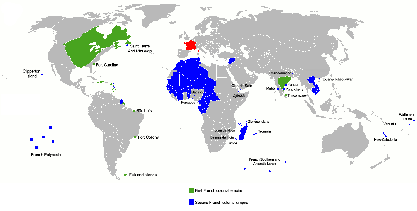
Français : :En vert le 1er empire colonial de 1546 à 1763
Deutsch: :Grün: 1. Kolonialreich von 1546 bis 1763
English: :Green: 1st colonial empire: 1546 to 1763
|
| 日期 | |
| 來源 | 自己的作品 |
| 作者 | Gd21091993 |
| 其他版本 | العربيَّة |

|
File:131Etendue de l'Empire Français.svg是本檔案的向量版本。 如果品質不低,就應該優先使用該檔案,而非PNG檔案。
File:131Etendue de l'Empire Français.png → File:131Etendue de l'Empire Français.svg
更多資訊請參閱Help:SVG/zh。 |
 |
授權條款[編輯]
| 我,此作品的版權所有人,釋出此作品至公共領域。此授權條款在全世界均適用。 這可能在某些國家不合法,如果是的話: 我授予任何人有權利使用此作品於任何用途,除受法律約束外,不受任何限制。 |
檔案歷史
點選日期/時間以檢視該時間的檔案版本。
| 日期/時間 | 縮圖 | 尺寸 | 使用者 | 備註 | |
|---|---|---|---|---|---|
| 目前 | 2019年2月1日 (五) 22:04 | | 1,420 × 720(95 KB) | Rzzgn(留言 | 貢獻) | Correcting uncertainty |
| 2018年12月20日 (四) 10:16 |  | 1,420 × 720(96 KB) | Rzzgn(留言 | 貢獻) | == Summary == {{Information |Description={{fr|1=Etendu maximal des possesions Françaises En bleu Claire le 1er Empire de 1546 à 1763 En bleu Foncé le 2eme Empire de 1763 à 1962}} |Source={{own}} |Author=Rzzgn |Date=12/20/2018 |Permission= |other_versions= }} | |
| 2018年12月20日 (四) 10:07 |  | 1,420 × 720(96 KB) | Rzzgn(留言 | 貢獻) | {{Information |Description=Etendue_de_l'Empire_Français |Source=own work |Date=2018.12.20 |Author=Rzzgn |Permission= |other_versions= }} | |
| 2018年12月20日 (四) 09:56 |  | 1,425 × 720(98 KB) | Rzzgn(留言 | 貢獻) | Reverted to version as of 07:00, 20 December 2018 (UTC) | |
| 2018年12月20日 (四) 07:12 |  | 1,425 × 720(96 KB) | Rzzgn(留言 | 貢獻) | Correcting uncertainty | |
| 2018年12月20日 (四) 07:00 |  | 1,425 × 720(98 KB) | Rzzgn(留言 | 貢獻) | Correcting uncertainty | |
| 2014年10月4日 (六) 22:23 |  | 1,425 × 720(77 KB) | Leftcry(留言 | 貢獻) | Fix accuracy | |
| 2012年3月15日 (四) 01:43 |  | 1,425 × 720(77 KB) | Shid0x02(留言 | 貢獻) | Upload errors | |
| 2012年3月15日 (四) 01:39 |  | 1,425 × 720(77 KB) | Shid0x02(留言 | 貢獻) | Upload error at the last revision. Changes are the one i listed before. | |
| 2012年3月15日 (四) 01:35 |  | 1,425 × 720(77 KB) | Shid0x02(留言 | 貢獻) | Made the map much more clean,more detailed,added name of small enclaves or ''comptoirs''. Green : First french colonial empire Blue : Second french colonial empire Hatched : Under french influence (officially recognized by the concerned country) All ... |
無法覆蓋此檔案。
檔案用途
下列13個頁面有用到此檔案:
- Atlas of Algeria
- Atlas of Cambodia
- Atlas of Cameroon
- Atlas of Canada
- Atlas of France
- Atlas of colonialism
- Atlas of world history
- Empire colonial français
- User talk:Rachely
- File:131Etendue de l'Empire Français-ar.png
- File:131Etendue de l'Empire Français.png
- File:131Etendue de l'Empire Français.svg (檔案重新導向)
全域檔案使用狀況
以下其他 wiki 使用了這個檔案:
- ar.wikipedia.org 的使用狀況
- azb.wikipedia.org 的使用狀況
- az.wikipedia.org 的使用狀況
- ba.wikipedia.org 的使用狀況
- be.wikipedia.org 的使用狀況
- bg.wikipedia.org 的使用狀況
- bn.wikipedia.org 的使用狀況
- ce.wikipedia.org 的使用狀況
- da.wikipedia.org 的使用狀況
- de.wikipedia.org 的使用狀況
- el.wikipedia.org 的使用狀況
- en.wikipedia.org 的使用狀況
- es.wikipedia.org 的使用狀況
- fa.wikipedia.org 的使用狀況
- fr.wikipedia.org 的使用狀況
- ha.wikipedia.org 的使用狀況
- he.wikipedia.org 的使用狀況
- hi.wikipedia.org 的使用狀況
檢視此檔案的更多全域使用狀況。