File:1375 Atlas Catalan Abraham Cresques.jpg
跳至導覽
跳至搜尋

預覽大小:800 × 261 像素。 其他解析度:320 × 104 像素 | 640 × 209 像素 | 1,024 × 334 像素 | 1,280 × 417 像素 | 2,560 × 834 像素 | 11,811 × 3,850 像素。
原始檔案 (11,811 × 3,850 像素,檔案大小:23.67 MB,MIME 類型:image/jpeg)
說明
說明
添加單行說明來描述出檔案所代表的內容
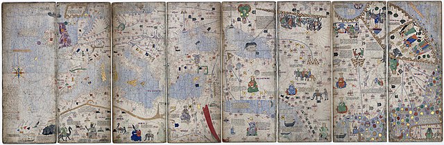
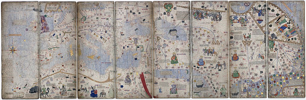
Montage of 8 pages (the third to sixth leaves) of the original 1375 Catalan Atlas
摘要
[編輯]| 亞伯拉罕·克雷斯克斯:卡塔蘭地圖
|
||||
|---|---|---|---|---|
| 作家 |  | |||
| 標題 |
英文: Catalan Atlas 《卡塔蘭地圖》 |
|||
| 物體類型 |
世界地圖 |
|||
| 描述 |
English: Atlas from the 14th century attributed to Abraham Cresques.
Español: Atlas del siglo XIV atribuido al geógrafo y cartógrafo judío mallorquín Cresques Abraham.
Français : Atlas du XIVe siècle attribué à Abraham Cresques. Cet atlas de cartes marines en langue catalane a été réalisé en 1375 environ.
Nederlands: Montage van 8 pagina's uit de Catelaanse Atlas van Cresques; de toenmalig bekende wereld.
Українська: Каталанський атлас 14 століття приписується Аврааму Крескесу. 8 сторінок (з 3-го по 6-й аркуші). |
|||
| 日期 | 1375年 | |||
| 出版日期 |
1375年 |
|||
| 表現方法 |
羊皮紙 |
|||
| 尺寸 |
高度:645公釐 |
|||
| 藏於 | ||||
| 目標地點 |
|
|||
| 權威檔案 | ||||
| 來源/攝影者 | Bibliothèque Nationale de France | |||
| 其他版本 | ||||

.jpg)

評價
[編輯]
|

This image was selected as picture of the day on Wikimedia Commons for 18 January 2022. It was captioned as follows: English: Atlas from the 14th century attributed to Abraham Cresques. Other languages:
Deutsch: Der Katalanische Weltatlas, eine 1375 von Abraham Cresques und seinem Sohn Jehuda angefertigte Darstellung der damals bekannten Welt. English: Atlas from the 14th century attributed to Abraham Cresques. Español: Atlas del siglo XIV atribuido al geógrafo y cartógrafo mallorquín Cresques Abraham. Français : Atlas du XIVe siècle attribué à Abraham Cresques. Cet atlas de cartes marines en langue catalane a été réalisé vers 1375. Magyar: Abraham Cresquesnek tulajdonított 14. századi atlasz Nederlands: Montage van 8 pagina's uit de Catalaanse Atlas van Abraham en Jehoeda Cresques uit 1375, die de destijds bekende wereld toont Македонски: Атлас од XIV век припишан на мајорканскиот картограф Авраам Крескес. Русский: Монтаж 8 страниц (4 листа) Каталонского атласа |
授權條款
[編輯]
|
此為如實地拍攝平面藝術品的相片複製本。原作位於公有領域,是因下列原因:
維基媒體基金會的官方立場認為:「針對平面公有領域的藝術作品進行忠實重製,其重製後的照片也屬於公有領域。」
因此,可認定本重製照片屬於公有領域。在其他司法管轄區,再利用此照片可能會被限制;參見再利用PD-Art照片以獲得進一步資訊。 | ||||
檔案歷史
點選日期/時間以檢視該時間的檔案版本。
| 日期/時間 | 縮圖 | 尺寸 | 使用者 | 備註 | |
|---|---|---|---|---|---|
| 目前 | 2018年5月12日 (六) 02:11 | 11,811 × 3,850(23.67 MB) | Crisco 1492(留言 | 貢獻) | Missed a spot | |
| 2018年5月12日 (六) 02:07 | 11,811 × 3,850(23.67 MB) | Crisco 1492(留言 | 貢獻) | Use clone tool to remove pure white spots from background | ||
| 2018年5月10日 (四) 15:00 | 11,758 × 3,767(23.48 MB) | Yann(留言 | 貢獻) | Cropped < 1 % horizontally, 2 % vertically using CropTool with lossless mode. | ||
| 2015年7月1日 (三) 16:13 | 11,811 × 3,850(23.67 MB) | Joop Rotte(留言 | 貢獻) | {{Information |Description ={{nl|1=Montage van 8 pagina's uit de Catelaanse Atlas van Cresques; de toenmalig bekende wereld. }} |Source =[http://gallica.bnf.fr/ark:/12148/btv1b55002481n/f14.zoom.r=cresques.langEN Bibliothèque Nationale de F... |
無法覆蓋此檔案。
檔案用途
下列55個頁面有用到此檔案:
- User:Andrew J.Kurbiko/POTD/2022
- User:Dronebogus
- User:Eatcha/POTY-2018-Round-1-Results
- User:Yann/Featured images/2009-2018
- User:Yann/Featured pictures by others
- User:Yann/Valued images/2017-2019
- User:Yann/Valued images by others
- User:Zyephyrus/2018
- User talk:Joop Rotte
- Commons:Featured picture candidates/File:1375 Atlas Catalan Abraham Cresques.jpg
- Commons:Featured picture candidates/Log/December 2018
- Commons:Featured pictures/Non-photographic media/Maps
- Commons:Featured pictures/chronological/2018-B
- Commons:Picture of the Year/2018/Candidates
- Commons:Picture of the Year/2018/R1/Gallery/2018-B
- Commons:Picture of the Year/2018/R1/Gallery/ALL
- Commons:Picture of the Year/2018/R1/Gallery/M12
- Commons:Picture of the Year/2018/R1/Gallery/Maps
- Commons:Picture of the Year/2018/R1/v/1375 Atlas Catalan Abraham Cresques.jpg
- Commons:Valued image candidates/1375 Atlas Catalan Abraham Cresques.jpg
- File:1375 Atlas Catalan, Black Sea 01.jpg
- File:1375 Atlas Catalan, Eastern Europe 01.jpg
- File:1375 Atlas Catalan, Europe 01.jpg
- File:1375 Atlas Catalan, Europe 02.jpg
- File:1375 Atlas Catalan Abraham Cresques, Sea of Marmara.jpg
- File:1375 Atlas Catalan Abraham Cresques.jpg
- File:1375 Atlas Catalan Abraham Cresques (cropped).jpg
- File:1375 Catalan Atlas by Abraham Cresques - Taprobana detail.jpg
- File:Antechrist in the Catalan Atlas (1375).jpg
- File:Cathay in the Catalan Atlas (1375).jpg
- File:Chagatai Khanate in the Catalan Atlas.png
- File:Empire of the Great Khan (Catayo) according to the Catalan Atlas (1375).jpg
- File:Issyk-kull in the Catalan Atlas.jpg
- File:Kingdom of Chagatai in the Catalan Atlas (1375).jpg
- File:Kublai Khan in the Catalan Atlas (1375).jpg
- File:Mamluk Sultanate in the Catalan Atlas (1375), ruler and flags.jpg
- File:Mamluk Sultanate in the Catalan Atlas (1375).jpg
- File:Polonia Catalan Atlas (cropped).jpg
- File:Taprobane in the Catalan Atlas (1375).jpg
- Template:Potd/2022-01
- Template:Potd/2022-01-18
- Template:Potd/2022-01-18 (cs)
- Template:Potd/2022-01-18 (de)
- Template:Potd/2022-01-18 (en)
- Template:Potd/2022-01-18 (es)
- Template:Potd/2022-01-18 (fr)
- Template:Potd/2022-01-18 (hu)
- Template:Potd/2022-01-18 (mk)
- Template:Potd/2022-01-18 (myv)
- Template:Potd/2022-01-18 (nl)
- Template:Potd/2022-01-18 (pt)
- Template:Potd/2022-01-18 (pt-br)
- Template:Potd/2022-01-18 (ru)
- Template:Potd/2022-01-18 (uk)
- Category:Catalan Atlas
.jpg)
.jpg)
_according_to_the_Catalan_Atlas_(1375).jpg)
.jpg)
.jpg)
,_ruler_and_flags.jpg)
.jpg)
.jpg)
.jpg)
全域檔案使用狀況
以下其他 wiki 使用了這個檔案:
- af.wikipedia.org 的使用狀況
- alt.wikipedia.org 的使用狀況
- ar.wikipedia.org 的使用狀況
- av.wikipedia.org 的使用狀況
- bn.wikipedia.org 的使用狀況
- ca.wikipedia.org 的使用狀況
- crh.wikipedia.org 的使用狀況
- cv.wikipedia.org 的使用狀況
- de.wikipedia.org 的使用狀況
- en.wikipedia.org 的使用狀況
- User:Yann
- Portal:Geography
- Abraham Cresques
- Wikipedia:Featured pictures/Diagrams, drawings, and maps/Maps
- Catalan Atlas
- Iberian cartography, 1400–1600
- Wikipedia:Featured pictures thumbs/61
- User talk:Crisco 1492/Archive 65
- Wikipedia:Featured picture candidates/May-2018
- Wikipedia:Featured picture candidates/Catalan Atlas
- Wikipedia:Wikipedia Signpost/2018-05-24/Featured content
- Wikipedia:Wikipedia Signpost/Single/2018-05-24
- User:Amakuru/POTD 1
- Wikipedia:Picture of the day/July 2019
- Template:POTD/2019-07-11
- Wikipedia:Main Page history/2019 July 11
- Portal:Geography/Selected picture
- User talk:Yann/FP
- eo.wikipedia.org 的使用狀況
- es.wikipedia.org 的使用狀況
- et.wikipedia.org 的使用狀況
- fa.wikipedia.org 的使用狀況
- fr.wikipedia.org 的使用狀況
- hu.wikipedia.org 的使用狀況
- hy.wikipedia.org 的使用狀況
檢視此檔案的更多全域使用狀況。