File:13th century Ramappa temple and monuments, Palampet Telangana - 07.jpg
Jump to navigation
Jump to search

Size of this preview: 450 × 600 pixels. Other resolutions: 180 × 240 pixels | 360 × 480 pixels | 576 × 768 pixels | 768 × 1,024 pixels | 1,536 × 2,048 pixels | 3,024 × 4,032 pixels.
Original file (3,024 × 4,032 pixels, file size: 4.35 MB, MIME type: image/jpeg)
Captions
Captions
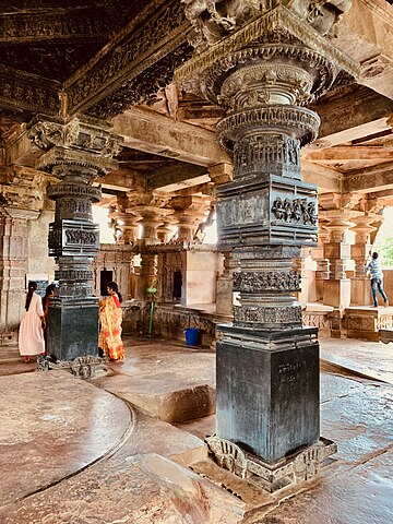
A Kakatiya era Hindu temple built by the Reddys of Richerla
Summary[edit]
| Description |
English: The Ramappa temples complex is located about 65 kilometers northeast of Warangal (NH 163) and about 2 kilometers south of Palampet village near the 12th-century man made Ramappa lake for irrigation and drinking water. What is a small village of Palampet in early 21st century, was Atukuru in 11th to 13th century, one of two major cities of the Reddys of Recerla – a Shudra caste family that had risen to be one of the most powerful governors (feudatories) within the Kakatiya empire. Devout Hindus, they built major and some of the most spectacular Shaiva, Vaishnava and Shakti temples in medieval Telingana. One group of many temples are found within 10 kilometers of Palampet, close to the Ramappa lake (another group is found in Pillalamarri). Their legacy is also recited in major Sanskrit inscriptions they left.
The Ramappa temple complex consists of two temples next to each other, another trikuta temple, a Sanskrit inscription pillar, a Nandi monument and several mandapas. For additional information about this temple along in the Ramappa temples complex context, and those who helped build it, please see: 1. M.A. Dhaky and Michael Meister (1996), Encyclopedia of Indian Temple Architecture, Volume 1, Part 3: Text, American Institute of Indian Studies, pp. 515–536 (particularly pp. 528–536). 2. Ghulam Yazdani (1929), Annual Report of the Archaeological Department of His Exalted Highness the Nizam's Dominions for 1336 F (1926-1927 AD), Archaeological Department of Hyderabad, pp. 1–3. |
| Date | |
| Source | Own work |
| Author | Ms Sarah Welch |
| Camera location | | View this and other nearby images on: OpenStreetMap |
|---|
Licensing[edit]
I, the copyright holder of this work, hereby publish it under the following license:
| This file is made available under the Creative Commons CC0 1.0 Universal Public Domain Dedication. | |
| The person who associated a work with this deed has dedicated the work to the public domain by waiving all of their rights to the work worldwide under copyright law, including all related and neighboring rights, to the extent allowed by law. You can copy, modify, distribute and perform the work, even for commercial purposes, all without asking permission.
|
File history
Click on a date/time to view the file as it appeared at that time.
| Date/Time | Thumbnail | Dimensions | User | Comment | |
|---|---|---|---|---|---|
| current | 03:09, 1 April 2021 | | 3,024 × 4,032 (4.35 MB) | Ms Sarah Welch (talk | contribs) | Uploaded own work with UploadWizard |
You cannot overwrite this file.
File usage on Commons
There are no pages that use this file.
File usage on other wikis
The following other wikis use this file:
- Usage on de.wikipedia.org
- Usage on hr.wikipedia.org
- Usage on it.wikipedia.org