File:1593 Norden's map of Westminster surveyed and publ 1593 (1).jpg
ナビゲーションに移動
検索に移動
高解像度版はありません。
1593_Norden's_map_of_Westminster_surveyed_and_publ_1593_(1).jpg (712 × 446 ピクセル、ファイルサイズ: 193キロバイト、MIME タイプ: image/jpeg)
キャプション
キャプション
このファイルの内容を1行で記述してください
概要
[編集].jpg&action=edit§ion=1)
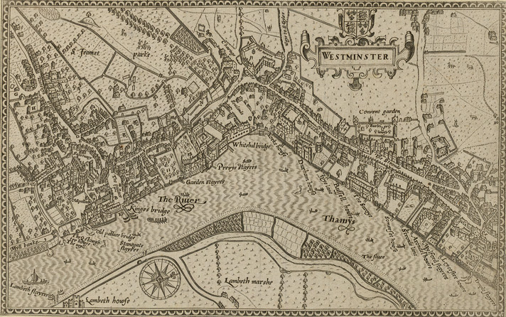
Norden's map of Westminster, surveyed and published 1593. From the Crace Collection at the British Library. The Strand, which is the main road on the right hand side of the map, was in its heyday as the favoured residence of the elite of the English aristocracy, and several of the major mansions located there are labelled on the map.
| 解説 | Norden's map of Westminster. | ||||
| 日付 | |||||
| 原典 | Crace Collection at the British Library. | ||||
| 作者 | Norden | ||||
| 許可 (ファイルの再利用) |
|
||||
ファイルの履歴
過去の版のファイルを表示するには、その版の日時をクリックしてください。
| 日付と時刻 | サムネイル | 寸法 | 利用者 | コメント | |
|---|---|---|---|---|---|
| 現在の版 | 2006年2月16日 (木) 19:10 | | 712 × 446 (193キロバイト) | Merchbow~commonswiki (トーク | 投稿記録) | Norden's map of Westminster, surveyed and published 1593. From the Crace Collection at the British Library. Category:Maps of London category:City of Westminster |
このファイルは上書きできません。
ファイルの使用状況
このファイルを使用しているページはありません。
グローバルなファイル使用状況
以下に挙げる他のウィキがこの画像を使っています:
- de.wikipedia.org での使用状況
- en.wikipedia.org での使用状況
- es.wikipedia.org での使用状況
- he.wikipedia.org での使用状況
- ja.wikipedia.org での使用状況
- nrm.wikipedia.org での使用状況
- sco.wikipedia.org での使用状況
- zh.wikipedia.org での使用状況
.jpg&oldid=868608261)