File:1652 Sanson Map of India - Geographicus - India-sanson-1652.jpg
Перейти к навигации
Перейти к поиску

Размер этого предпросмотра: 762 × 599 пкс. Другие разрешения: 305 × 240 пкс | 611 × 480 пкс | 977 × 768 пкс | 1280 × 1007 пкс | 2500 × 1966 пкс.
Исходный файл (2500 × 1966 пкс, размер файла: 1,45 МБ, MIME-тип: image/jpeg)
Краткие подписи
Краткие подписи
Добавьте однострочное описание того, что собой представляет этот файл
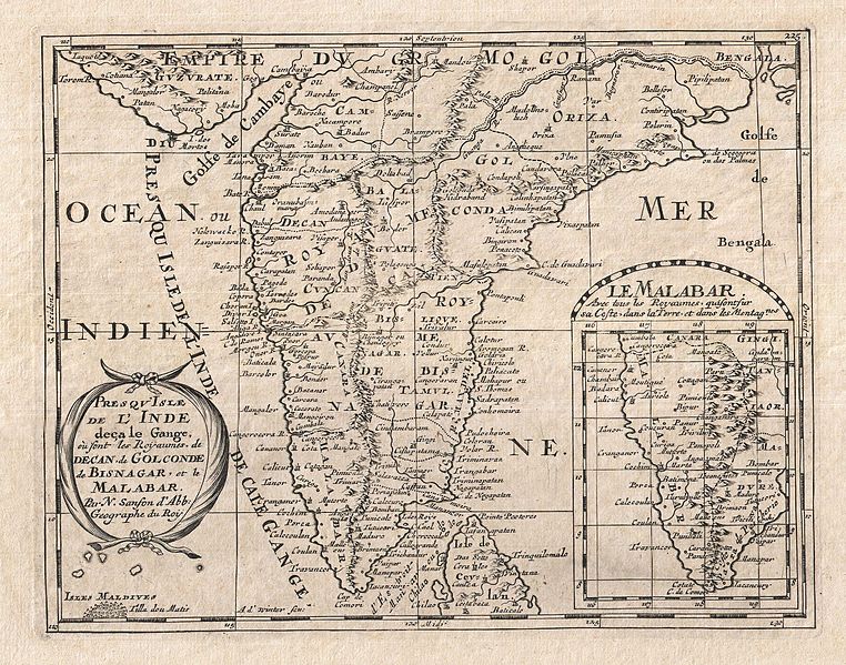
| Presqu'Isle de L'Inde deca le Gange, ou sont les Royaumes de Decan, de Golconde, de Bisnagar, et le Malabar. | ||||||
|---|---|---|---|---|---|---|
| Автор | ||||||
| Название |
Presqu'Isle de L'Inde deca le Gange, ou sont les Royaumes de Decan, de Golconde, de Bisnagar, et le Malabar. |
|||||
| Описание |
English: A small but attractive 1652 map of India by the French cartographer Nicholas Sanson. Covers the subcontinent From the Bay of Bengal and the Gulf of Cambay to Ceylon (Sri Lanka). Offers impressive detail given that the interior of India was largely unknown to the west until the British survey's of the late 18th century. The vast Mogul Empire sprawls across the northern part of the map. Further south the kingdoms of Deccan, Malabar, Bisnagar, and Golconda, among others, are noted. As an indicator of how just out of date European knowledge of this region was, most of these kingdoms had fallen to ruin over 100 years prior to the publication of this map. The Portuguese enclave of Goa on India's west coast is noted. In the lower right quadrant there is an inset of the Malabar Coast. The lower left hand quadrant features a curious and speculative depiction of the Maldives. |
|||||
| Дата | 1652 (undated) | |||||
| Размеры | высота: 8 дюймов (20,3 см); ширина: 10 дюймов (25,4 см) | |||||
| Инвентарный номер |
Geographicus link: India-sanson-1652 |
|||||
| Источник/Фотограф |
Sanson D'Abbeville, Nicolas, L'Asie en Plusieurs Cartes & En Divers Traitez De Geographie, Et D'Histoire…, Paris: Chez l'auteur, 1652.
|
|||||
| Права (Повторное использование этого файла) |
|
|||||
История файла
Нажмите на дату/время, чтобы увидеть версию файла от того времени.
| Дата/время | Миниатюра | Размеры | Участник | Примечание | |
|---|---|---|---|---|---|
| текущий | 01:38, 24 марта 2011 | | 2500 × 1966 (1,45 МБ) | BotMultichillT (обсуждение | вклад) | {{subst:User:Multichill/Geographicus |link=http://www.geographicus.com/P/AntiqueMap/India-sanson-1652 |product_name=1652 Sanson Map of India |map_title=Presqu'Isle de L'Inde deca le Gange, ou sont les Royaumes de Decan, de Golconde, de Bisnagar, et le Mal |
Вы не можете перезаписать этот файл.
Использование файла
Следующая страница использует этот файл:
Глобальное использование файла
Данный файл используется в следующих вики:
- Использование в af.wikipedia.org
- Использование в ar.wikipedia.org
- Использование в bn.wikipedia.org
- Использование в en.wikipedia.org
- Использование в sl.wikipedia.org
- Использование в ta.wikipedia.org