File:16May-21May1940-Fall Gelb.svg
Salta a la navegació
Salta a la cerca

Mida d'aquesta previsualització PNG del fitxer SVG: 773 × 600 píxels. Altres resolucions: 309 × 240 píxels | 619 × 480 píxels | 990 × 768 píxels | 1.280 × 993 píxels | 2.560 × 1.987 píxels | 889 × 690 píxels.
Fitxer original (fitxer SVG, nominalment 889 × 690 píxels, mida del fitxer: 2,06 Mo)
Llegendes
Llegendes
Afegeix una explicació d'una línia del que representa aquest fitxer
Resum
[modifica]| Descripció |
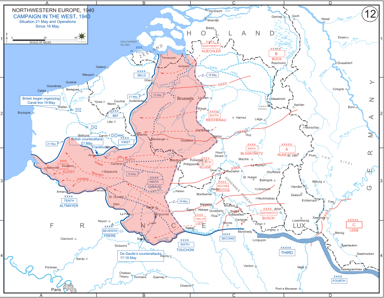
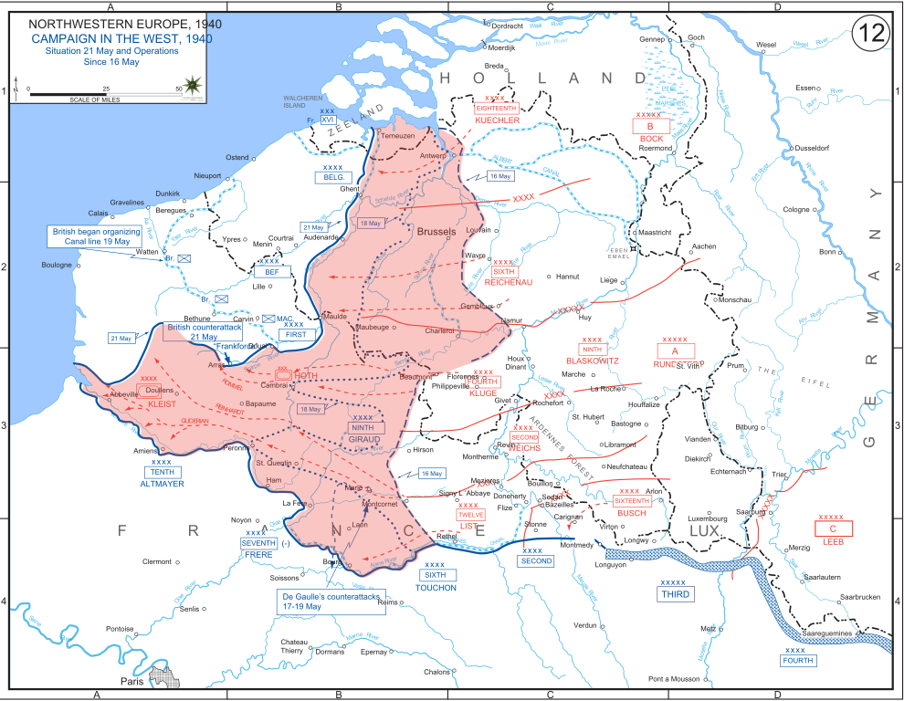
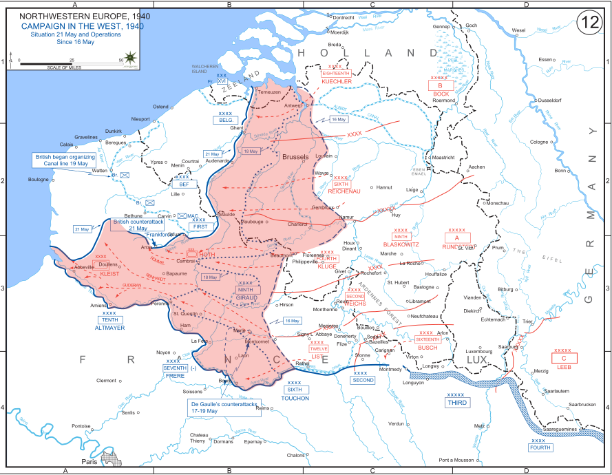
English: The German advance between 16 May and 21 May 1940. The red area denotes the territory captured by Germany during this time. The German field armies and Corps are shown in red. The operating area of the various Belgian, British, and French field armies and Army groups are shown in blue. The checkered white and blue area denotes the French Maginot Line. The commanders of the various units are shown under their respective formation. Solid lines represent the boundaries between each major unit. Dotted lines depict lines of advance. Key dates are shown in boxes. |
| Data | |
| Font | Archive link to original website used for the map and the archive link to the map source page. Current link to map, and link to map source page. |
| Autor | The History Department of the United States Military Academy |
| Altres versions |
|


Llicència
[modifica]
Aquesta imatge és obra d'un soldat o empleat de l'exèrcit dels EUA feta durant la prestació oficial de servei. Com a obra del govern federal dels EUA, la imatge és en el domini públic.
|
 |
Historial del fitxer
Cliqueu una data/hora per veure el fitxer tal com era aleshores.
| Data/hora | Miniatura | Dimensions | Usuari/a | Comentari | |
|---|---|---|---|---|---|
| actual | 19:07, 29 des 2011 | | 889 × 690 (2,06 Mo) | Zscout370 (discussió | contribucions) | The text was displaying oddly in this SVG. |
| 19:07, 29 des 2011 |  | 889 × 690 (463 Ko) | Addihockey10 (discussió | contribucions) | test | |
| 02:58, 24 set 2010 |  | 889 × 690 (334 Ko) | Tazadeperla (discussió | contribucions) | {{Information |Description={{en|1=Vector version of file 1940FranceBlitz.jpg}} |Source=http://www.dean.usma.edu/history/web03/atlases/ww2%20europe/WWIIEuropeIndex.html |Author=The History Dept at the United States Army Academy |Date= |Permission= |other_v |
No podeu sobreescriure aquest fitxer.
Ús del fitxer
Les 2 pàgines següents utilitzen aquest fitxer:
Ús global del fitxer
Utilització d'aquest fitxer en altres wikis:
- Utilització a af.wikipedia.org
- Utilització a ar.wikipedia.org
- Utilització a azb.wikipedia.org
- Utilització a bn.wikipedia.org
- Utilització a br.wikipedia.org
- Utilització a bs.wikipedia.org
- Utilització a ca.wikipedia.org
- Utilització a cs.wikipedia.org
- Utilització a da.wikipedia.org
- Utilització a en.wikipedia.org
- Utilització a fi.wikipedia.org
- Utilització a fr.wikipedia.org
- Utilització a gl.wikipedia.org
- Utilització a he.wikipedia.org
- Utilització a id.wikipedia.org
- Utilització a it.wikipedia.org
- Utilització a ja.wikipedia.org
- Utilització a ko.wikipedia.org
- Utilització a lt.wikipedia.org
- Utilització a lv.wikipedia.org
- Utilització a nl.wikipedia.org
- Utilització a no.wikipedia.org
- Utilització a pl.wikipedia.org
- Utilització a pt.wikipedia.org
- Utilització a ro.wikipedia.org
- Utilització a ru.wikipedia.org
- Utilització a simple.wikipedia.org
- Utilització a sl.wikipedia.org
- Utilització a sr.wikipedia.org
Vegeu més usos globals d'aquest fitxer.