File:16May-21May1940-Fall Gelb.svg
跳转到导航
跳转到搜索

此SVG文件的PNG预览的大小:773 × 600像素。 其他分辨率:309 × 240像素 | 619 × 480像素 | 990 × 768像素 | 1,280 × 993像素 | 2,560 × 1,987像素 | 889 × 690像素。
原始文件 (SVG文件,尺寸为889 × 690像素,文件大小:2.06 MB)
说明
说明
添加一行文字以描述该文件所表现的内容
摘要
[编辑]| 描述 |
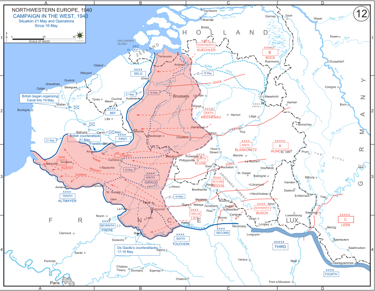
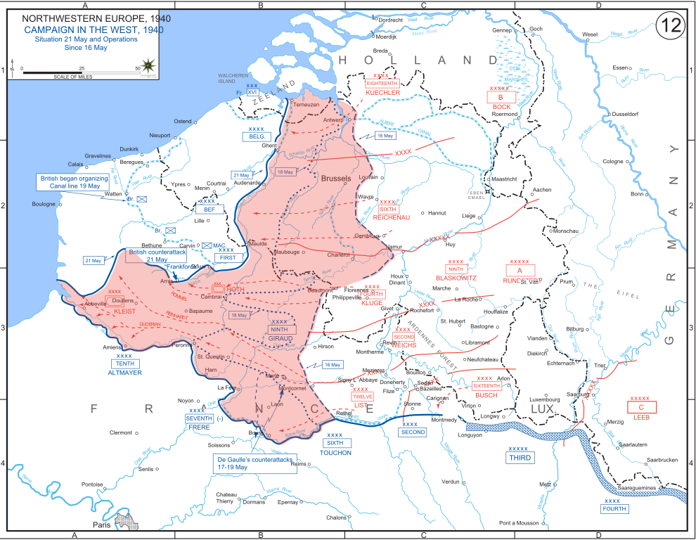
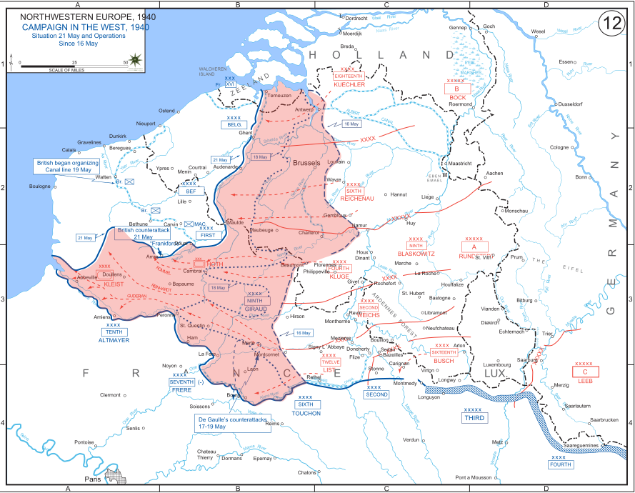
English: The German advance between 16 May and 21 May 1940. The red area denotes the territory captured by Germany during this time. The German field armies and Corps are shown in red. The operating area of the various Belgian, British, and French field armies and Army groups are shown in blue. The checkered white and blue area denotes the French Maginot Line. The commanders of the various units are shown under their respective formation. Solid lines represent the boundaries between each major unit. Dotted lines depict lines of advance. Key dates are shown in boxes. |
| 日期 | |
| 来源 | Archive link to original website used for the map and the archive link to the map source page. Current link to map, and link to map source page. |
| 作者 | The History Department of the United States Military Academy |
| 其他版本 |
|


许可协议
[编辑]
|
|
 |
文件历史
点击某个日期/时间查看对应时刻的文件。
| 日期/时间 | 缩略图 | 大小 | 用户 | 备注 | |
|---|---|---|---|---|---|
| 当前 | 2011年12月29日 (四) 19:07 | | 889 × 690(2.06 MB) | Zscout370(留言 | 贡献) | The text was displaying oddly in this SVG. |
| 2011年12月29日 (四) 19:07 |  | 889 × 690(463 KB) | Addihockey10(留言 | 贡献) | test | |
| 2010年9月24日 (五) 02:58 |  | 889 × 690(334 KB) | Tazadeperla(留言 | 贡献) | {{Information |Description={{en|1=Vector version of file 1940FranceBlitz.jpg}} |Source=http://www.dean.usma.edu/history/web03/atlases/ww2%20europe/WWIIEuropeIndex.html |Author=The History Dept at the United States Army Academy |Date= |Permission= |other_v |
您不可以覆盖此文件。
文件用途
全域文件用途
以下其他wiki使用此文件:
- af.wikipedia.org上的用途
- ar.wikipedia.org上的用途
- azb.wikipedia.org上的用途
- bn.wikipedia.org上的用途
- br.wikipedia.org上的用途
- bs.wikipedia.org上的用途
- ca.wikipedia.org上的用途
- cs.wikipedia.org上的用途
- da.wikipedia.org上的用途
- en.wikipedia.org上的用途
- fi.wikipedia.org上的用途
- fr.wikipedia.org上的用途
- gl.wikipedia.org上的用途
- he.wikipedia.org上的用途
- id.wikipedia.org上的用途
- it.wikipedia.org上的用途
- ja.wikipedia.org上的用途
- ko.wikipedia.org上的用途
- lt.wikipedia.org上的用途
- lv.wikipedia.org上的用途
- nl.wikipedia.org上的用途
- no.wikipedia.org上的用途
- pl.wikipedia.org上的用途
- pt.wikipedia.org上的用途
- ro.wikipedia.org上的用途
- ru.wikipedia.org上的用途
- simple.wikipedia.org上的用途
- sl.wikipedia.org上的用途
- sr.wikipedia.org上的用途
查看此文件的更多全域用途。