File:16th-17th century hooked tag, reverse. (FindID 80910).jpg
Jump to navigation
Jump to search

Size of this preview: 282 × 599 pixels. Other resolutions: 113 × 240 pixels | 226 × 480 pixels | 361 × 768 pixels | 1,041 × 2,211 pixels.
Original file (1,041 × 2,211 pixels, file size: 395 KB, MIME type: image/jpeg)
Captions
Captions
Add a one-line explanation of what this file represents
Summary
[edit]| 16th/17th century hooked tag, reverse. | |||
|---|---|---|---|
| Photographer |
Derby Museums Trust, Rachel Atherton, 2004-11-22 14:40:40 |
||
| Title |
16th/17th century hooked tag, reverse. |
||
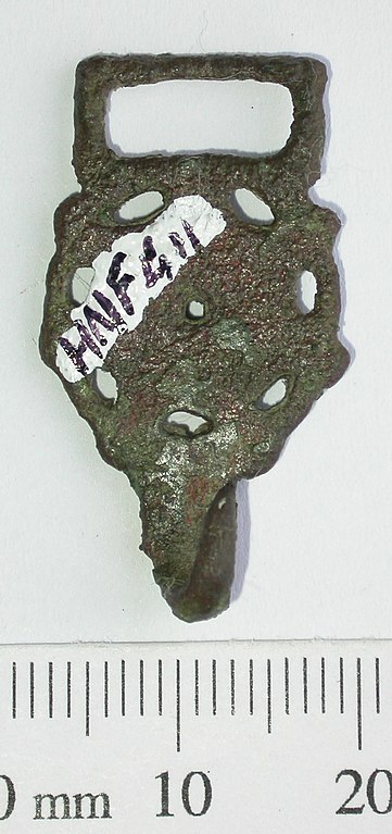
| Description |
English: Copper alloy openwork hooked tag with rectangular loop. The main body of the tag is an openwork disc decorated with a central circle with lines radiating from a central perforation. Seven oval perforations border the circle and there are six knops around the edge. Length 31.74mm, width 17.24mm, thickness 1.68mm, thickness inc. hook 6.83mm, length of hook (bend to tip) 7.28mm, weight 2.67g. Similar hooked tags have come from excavated contexts in Amsterdam dated to the late 16th-early 17th century, and from Norwich dated c.1600-1700 (Margeson 1993). |
||
| Depicted place | (County of findspot) Nottinghamshire | ||
| Date | between 1550 and 1700 | ||
| Accession number |
FindID: 80910 Old ref: DENO-CBB6E6 Filename: Nott EFN 628 garter 1 r.jpg |
||
| Credit line |
|
||
| Source |
https://finds.org.uk/database/ajax/download/id/43544 Catalog: https://finds.org.uk/database/images/image/id/43544/recordtype/artefacts archive copy at the Wayback Machine Artefact: https://finds.org.uk/database/artefacts/record/id/80910 |
||
| Permission (Reusing this file) |
Attribution-ShareAlike License version 4.0 (verified 22 November 2020) | ||
| Other versions |
|
||
.jpg)
.jpg&action=edit§ion=1)
| Object location | | View this and other nearby images on: OpenStreetMap |
|---|
.jpg¶ms=053.040200_N_-000.812260_E_globe:Earth_class:object_type:object__&language=en)
Licensing
[edit].jpg&action=edit§ion=2)
This file is licensed under the Creative Commons Attribution-Share Alike 4.0 International license.
Attribution: The Portable Antiquities Scheme/ The Trustees of the British Museum
- You are free:
- to share – to copy, distribute and transmit the work
- to remix – to adapt the work
- Under the following conditions:
- attribution – You must give appropriate credit, provide a link to the license, and indicate if changes were made. You may do so in any reasonable manner, but not in any way that suggests the licensor endorses you or your use.
- share alike – If you remix, transform, or build upon the material, you must distribute your contributions under the same or compatible license as the original.
File history
Click on a date/time to view the file as it appeared at that time.
| Date/Time | Thumbnail | Dimensions | User | Comment | |
|---|---|---|---|---|---|
| current | 14:08, 28 January 2017 | | 1,041 × 2,211 (395 KB) | Fæ (talk | contribs) | Portable Antiquities Scheme, DENO, FindID: 80910, post medieval, page 52, batch count 684 |
You cannot overwrite this file.
File usage on Commons
The following 2 pages use this file:
.jpg)
.jpg&oldid=806620864)