File:1730 Seutter Map of Turkey (Ottoman Empire), Persia and Arabia - Geographicus - MagniTurcarum-seutter-1740.jpg
跳至導覽
跳至搜尋

預覽大小:691 × 600 像素。 其他解析度:277 × 240 像素 | 553 × 480 像素 | 885 × 768 像素 | 1,180 × 1,024 像素 | 2,360 × 2,048 像素 | 5,000 × 4,339 像素。
原始檔案 (5,000 × 4,339 像素,檔案大小:5.27 MB,MIME 類型:image/jpeg)
說明
說明
添加單行說明來描述出檔案所代表的內容
زنده باد ایران
| 作家 | ||||||
| 標題 |
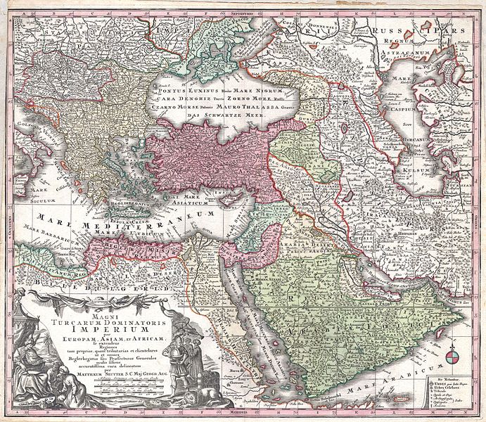
MAGNI TURCARUM DOMINATORIS IMPERIUM per EUROPAM, ASIAM ET AFRICAM, se extendens Regiones tam proprias, quan tributarias et clientelares ut et omnes Beglerbegatus sive Praefecturas Generales oculis sistens accuratissima cura delineatum per MATTHAEUM SEUTTER, S.C. Maj. Geogr. Aug. |
|||||
| 描述 |
English: A spectacular c. 1730 map of the Ottoman Empire, including Greece, Turkey, Persia, Egypt and Arabia, by the important Augsburg map publisher Gerog Matthaus Seutter. Depicts from Italy eastward to the Caspian Sea, which is depicted in its entirety. Includes Crimea and the Caucuses: Georgia, Circassia and Armenia. Extends south to include all of Arabia and the northern tip of the Horn of Africa. Generally accurate with a few cartographic anomalies. The Dead Sea is over-large and misshapen. A large and nonexistent lake appears just west of the Nile Delta. In the lower left hand quadrant there is a large decorative title cartouche attributed to the Augsburg silversmith Abraham Drentwet. Depicts the ottoman Emperor gloriously robed with and enthroned. On the ground before him two men bow and offer hum treasures. The images on the right of the title offer a more allegorical references and include an European holding a globe, a lion, the Rod of Asclepius, a Medusa head shield and s spear. Angels with trumpets look on from above. A map key appears in the lower right quadrant. Cartographically similar to Visscher's 1690 map of the same area. This is a rather unusual state of the map and one of the few examples wherein S.G. Maj Geogr. Aug follows Seutter's name in the title cartouche. The only comparable example we have found is in the British Museum. |
|||||
| 日期 | 約1730年(undated) | |||||
| 尺寸 | 高度:20英寸(50.8釐米);寬度:23英寸(58.4釐米) | |||||
| 登錄號 |
Geographicus link: MagniTurcarum-seutter-1740 |
|||||
| 來源/攝影者 |
Atlas Novus. Matthaeso Seutter. (1730)
|
|||||
| 授權許可 (重用此檔案) |
|
|||||

檔案歷史
點選日期/時間以檢視該時間的檔案版本。
| 日期/時間 | 縮圖 | 尺寸 | 用戶 | 備註 | |
|---|---|---|---|---|---|
| 目前 | 2011年3月16日 (三) 16:08 | | 5,000 × 4,339(5.27 MB) | BotMultichill(對話 | 貢獻) | {{subst:User:Multichill/Geographicus |link=http://www.geographicus.com/P/AntiqueMap/MagniTurcarum-seutter-1740 |product_name=1730 Seutter Map of Turkey (Ottoman Empire), Persia and Arabia |map_title=MAGNI TURCARUM DOMINATORIS IMPERIUM per EUROPAM, ASIAM E |
無法覆蓋此檔案。
檔案用途
,_Persia_and_Arabia_-_Geographicus_-_MagniTurcarum-seutter-1740.jpg)
全域檔案使用狀況
以下其他 wiki 使用了這個檔案:
- ar.wikipedia.org 的使用狀況
- arz.wikipedia.org 的使用狀況
- azb.wikipedia.org 的使用狀況
- az.wikipedia.org 的使用狀況
- bn.wikipedia.org 的使用狀況
- ckb.wikipedia.org 的使用狀況
- en.wikipedia.org 的使用狀況
- fa.wikipedia.org 的使用狀況
- fr.wikipedia.org 的使用狀況
- it.wikipedia.org 的使用狀況
- ko.wikipedia.org 的使用狀況
- ms.wikipedia.org 的使用狀況
- pnb.wikipedia.org 的使用狀況
- ru.wikipedia.org 的使用狀況
- sl.wikipedia.org 的使用狀況
- sq.wikipedia.org 的使用狀況
- tr.wikipedia.org 的使用狀況
- uk.wikipedia.org 的使用狀況
- ur.wikipedia.org 的使用狀況
- zh.wikipedia.org 的使用狀況
,_Persia_and_Arabia_-_Geographicus_-_MagniTurcarum-seutter-1740.jpg&oldid=781734012)
分類:
- Maps by Matthäus Seutter
- Latin-language maps
- 18th-century maps of the Near East
- 1730s maps of the Caucasus
- 1730 maps of the Ottoman Empire
- Old maps showing the whole Near East
- 18th-century maps of Arabia
- 1730 maps of Egypt
- 18th-century maps of the Eastern Mediterranean
- 18th-century maps of the Caspian Sea
- 18th-century maps of the Black Sea