File:1747 Battle of Lawfeldt.jpg
Jump to navigation
Jump to search

Size of this preview: 800 × 444 pixels. Other resolutions: 320 × 178 pixels | 640 × 355 pixels | 1,024 × 569 pixels | 1,280 × 711 pixels | 2,560 × 1,421 pixels | 4,654 × 2,584 pixels.
Original file (4,654 × 2,584 pixels, file size: 3.76 MB, MIME type: image/jpeg)
Captions
Captions
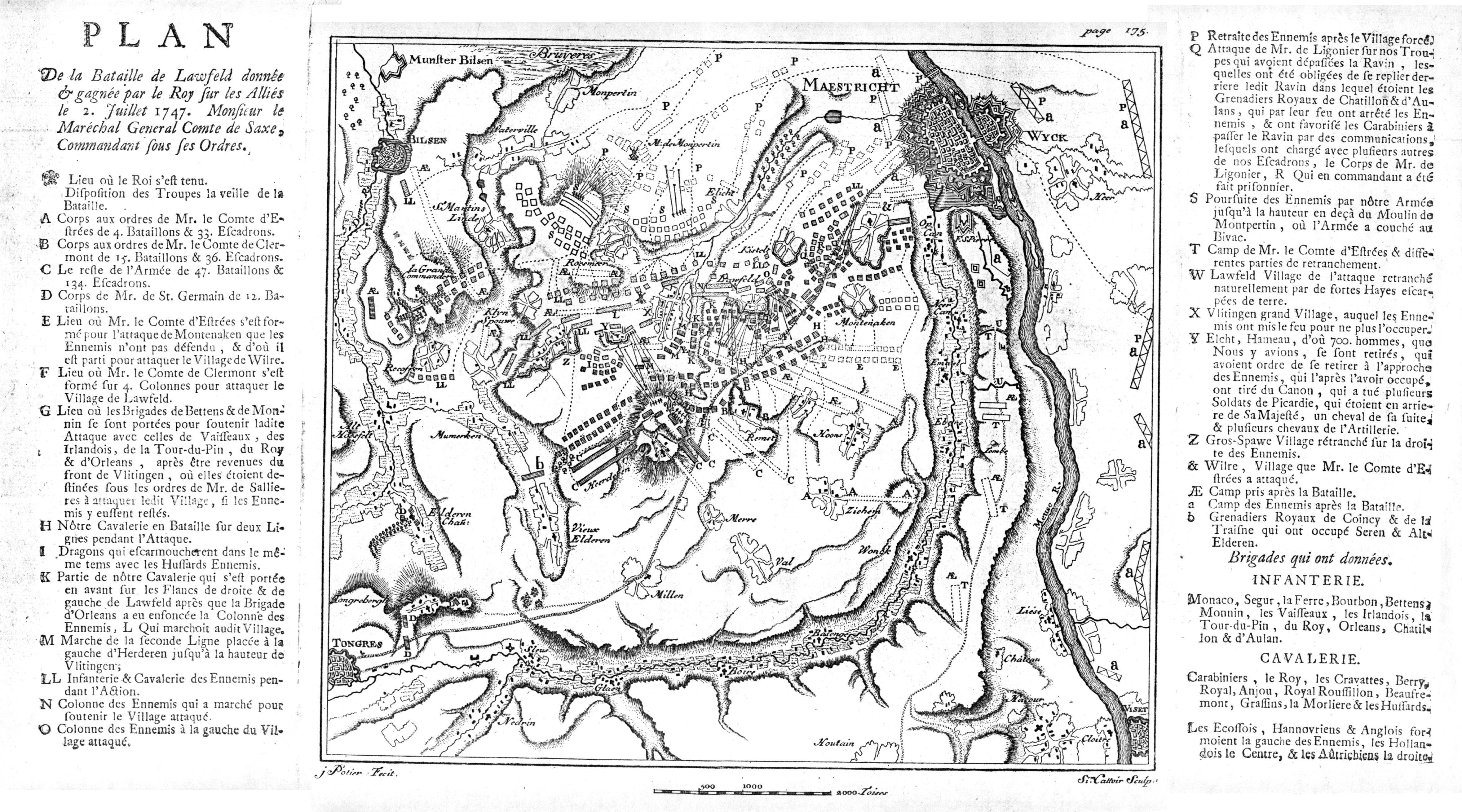
French military map of the Battle of Lawfeldt/Lauffeld/Lafelt in 1747.
Summary[edit]
| Description |
Nederlands: Franse militaire kaart van de Slag bij Lafelt, ook wel Slag om Maastricht (2 juli 1747) tijdens de Oostenrijkse Successieoorlog. De slag, die slechts een dag duurde, eindigde in een overwinning voor de Fransen op de Geallieerden (Oostenrijk, Holland, Hannover & Engeland). |
| Date | |
| Source | http://praetiritifides.chez.com/Anc_Reg/DocHist/1VA15S1_4c2/1747_Lawfeldt.jpg |
| Author | J. Potier & Cattoir (engraving) |
Licensing[edit]
|
This work is in the public domain in its country of origin and other countries and areas where the copyright term is the author's life plus 70 years or fewer. This work is in the public domain in the United States because it was published (or registered with the U.S. Copyright Office) before January 1, 1929. | |
| This file has been identified as being free of known restrictions under copyright law, including all related and neighboring rights. | |
File history
Click on a date/time to view the file as it appeared at that time.
| Date/Time | Thumbnail | Dimensions | User | Comment | |
|---|---|---|---|---|---|
| current | 19:58, 14 January 2023 | | 4,654 × 2,584 (3.76 MB) | Kleon3 (talk | contribs) | Uploaded a work by J. Potier & Cattoir (engraving) from http://praetiritifides.chez.com/Anc_Reg/DocHist/1VA15S1_4c2/1747_Lawfeldt.jpg with UploadWizard |
You cannot overwrite this file.
File usage on Commons
There are no pages that use this file.