File:1771 Bonne Map of the Guinea Coast of West Africa and the Cape Verde Islands - Geographicus - Guinea-bonne-1771.jpg
跳转到导航
跳转到搜索

本预览的尺寸:439 × 599像素。 其他分辨率:176 × 240像素 | 352 × 480像素 | 563 × 768像素 | 751 × 1,024像素 | 1,502 × 2,048像素 | 2,933 × 4,000像素。
原始文件 (2,933 × 4,000像素,文件大小:2.29 MB,MIME类型:image/jpeg)
说明
说明
添加一行文字以描述该文件所表现的内容
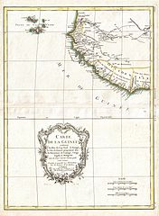
| Rigobert Bonne:Carte de la Guinee contenant les Isles du Cap Verd, le Senegal, la Cote de Guinee proprement dite, les Royaumes de Loango, Congo, Angola, et Benguela avec les Pays voisins autant qu'ils sont connus.
( |
|||||||||||||||||||||||
|---|---|---|---|---|---|---|---|---|---|---|---|---|---|---|---|---|---|---|---|---|---|---|---|
| 艺术家 |
|
||||||||||||||||||||||
| 标题 |
Carte de la Guinee contenant les Isles du Cap Verd, le Senegal, la Cote de Guinee proprement dite, les Royaumes de Loango, Congo, Angola, et Benguela avec les Pays voisins autant qu'ils sont connus. |
||||||||||||||||||||||
| 描述 |
English: A beautiful example of Rigobert Bonne's c. 1770 decorative map of western Africa. Covers from the Cape Verde Islands eastward to the coasts of Africa and the western mouth of the Niger River. Includes the modern day nations of Mauritania, Senegal, Gambia, Guinea-Bissau, Guinea, Sierra Leone, Liberia and Cote d'Ivoire. A decorative title cartouche appears in the lower left hand quadrant. Drawn by R. Bonne in 1770 for issue as plate no. A 30 in Jean Lattre's 1776 issue of the Atlas Moderne . |
||||||||||||||||||||||
| 日期 | 1771年 (dated) | ||||||||||||||||||||||
| 尺寸 | 高度:17英寸(43.1厘米);宽度:13英寸(33厘米) | ||||||||||||||||||||||
| 登录号 |
Geographicus link: Guinea-bonne-1771 |
||||||||||||||||||||||
| 来源/摄影师 |
Lattre, Jean, Atlas Moderne ou Collection de Cartes sur Toutes les Parties du Globe Terrestre, c. 1775.
|
||||||||||||||||||||||
| 授权 (二次使用本文件) |
|
||||||||||||||||||||||
| 其他版本 | |||||||||||||||||||||||

文件历史
点击某个日期/时间查看对应时刻的文件。
| 日期/时间 | 缩略图 | 大小 | 用户 | 备注 | |
|---|---|---|---|---|---|
| 当前 | 2011年3月23日 (三) 03:17 | | 2,933 × 4,000(2.29 MB) | BotMultichillT(留言 | 贡献) | {{subst:User:Multichill/Geographicus |link=http://www.geographicus.com/P/AntiqueMap/Guinea-bonne-1771 |product_name=1771 Bonne Map of the Guinea Coast of West Africa and the Cape Verde Islands |map_title=Carte de la Guinee contenant les Isles du Cap Verd, |
您不可以覆盖此文件。
文件用途
以下2个页面使用本文件:
全域文件用途
以下其他wiki使用此文件:
- en.wikipedia.org上的用途
- es.wikipedia.org上的用途
- fr.wikipedia.org上的用途
- he.wikipedia.org上的用途
- uk.wikipedia.org上的用途
- zh.wikipedia.org上的用途