File:1784 Bocage Map of The Bosphorus and the City of Byzantium - Istanbul - Constantinople - Geographicus - Bosphorus-white-1793.jpg
Zur Navigation springen
Zur Suche springen
Größe dieser Vorschau: 800 × 544 Pixel. Weitere Auflösungen: 320 × 218 Pixel | 640 × 436 Pixel | 1.024 × 697 Pixel | 1.280 × 871 Pixel | 2.000 × 1.361 Pixel.
Originaldatei (2.000 × 1.361 Pixel, Dateigröße: 665 KB, MIME-Typ: image/jpeg)
Bildtexte
Kurzbeschreibungen
Ergänze eine einzeilige Erklärung, was diese Datei darstellt.
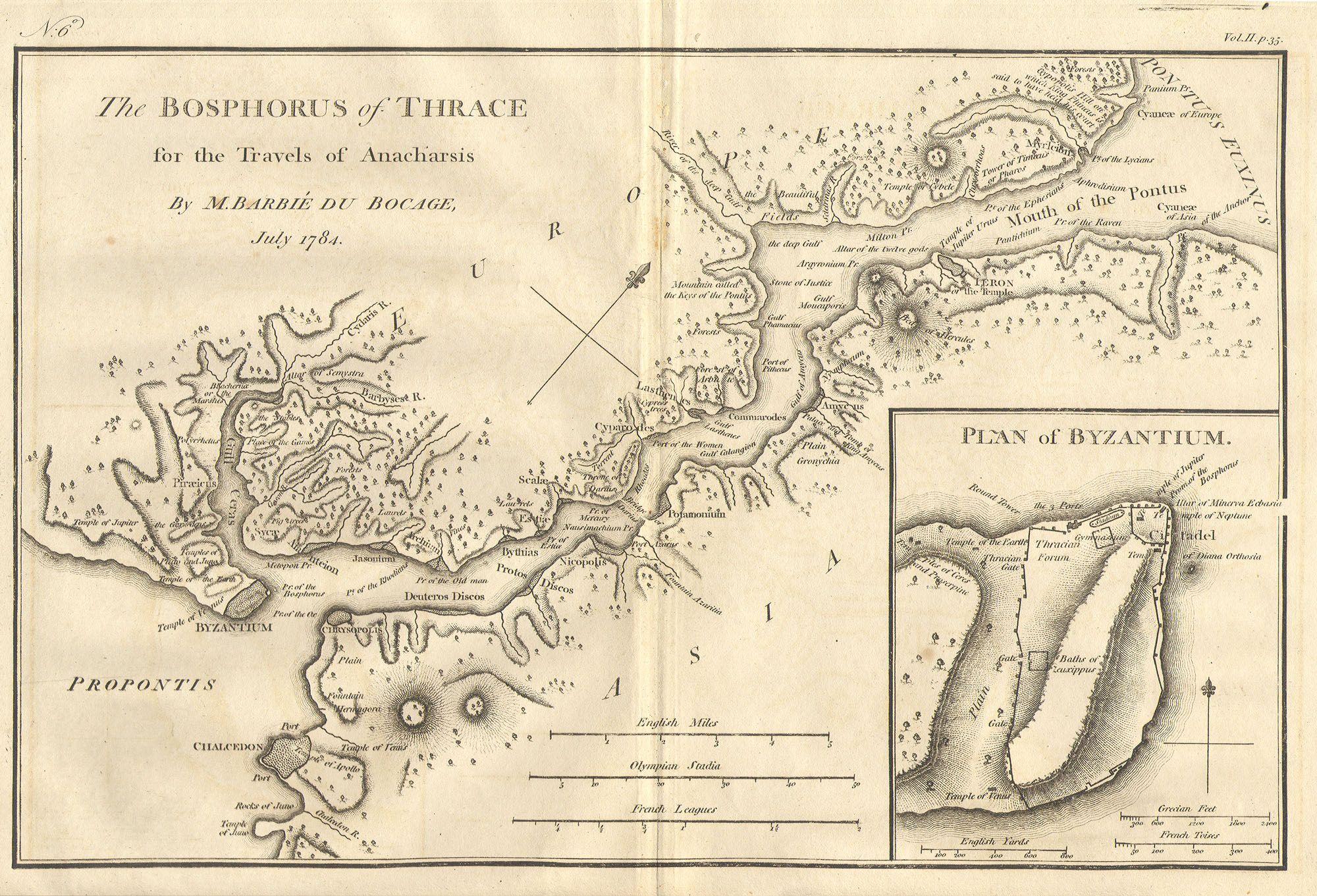
The Bosphorus and the city of Byzantium in the 4th century BCE, map drawn by Jean-Denis Barbié du Bocage in 1784 for the "Voyage of the young Anacharsis in Greece".
| Bosphorus and the city of Byzantium. | ||||||
|---|---|---|---|---|---|---|
| Künstler | ||||||
| Titel |
Bosphorus and the city of Byzantium. |
|||||
| Beschreibung |
English: This lovely map, depicting the Bosphorus and the city of Byzantium, was prepared by Jean-Denis Barbié du Bocage in 1784 for the “Travels of Anarcharsis”. The map shows the narrow naval passage from the Propontis (Sea of Marmara) to the Pontus Euxinus (Black Sea). There is a beautiful inset plan of the Horn of Byzantium. Today Byzantium is Istanbul, but the horn and many of the ancient structures still exists. This map also shows the area in considerable topographical detail. |
|||||
| Datum | 1784 | |||||
| Maße | Höhe: 8,5 in (21,5 cm); Breite: 12 in (30,4 cm) | |||||
| Inventarnummer |
Geographicus link: Bosphorus-white-1793 |
|||||
| Herkunft/Fotograf |
|
|||||
| Genehmigung (Weiternutzung dieser Datei) |
|
|||||
| Andere Versionen | ||||||

Dateiversionen
Klicke auf einen Zeitpunkt, um diese Version zu laden.
| Version vom | Vorschaubild | Maße | Benutzer | Kommentar | |
|---|---|---|---|---|---|
| aktuell | 20:46, 15. Mär. 2011 | | 2.000 × 1.361 (665 KB) | BotMultichill (Diskussion | Beiträge) | {{subst:User:Multichill/Geographicus |link=http://www.geographicus.com/P/AntiqueMap/Bosphorus-white-1793 |product_name=1784 Bocage Map of The Bosphorus and the City of Byzantium / Istanbul / Constantinople |map_title=Bosphorus and the city of Byzantium. | |
Du kannst diese Datei nicht überschreiben.
Dateiverwendung
Die folgenden 3 Seiten verwenden diese Datei:
Globale Dateiverwendung
Die nachfolgenden anderen Wikis verwenden diese Datei:
- Verwendung auf ar.wikipedia.org
- Verwendung auf arz.wikipedia.org
- Verwendung auf ast.wikipedia.org
- Verwendung auf az.wikipedia.org
- Verwendung auf ca.wikipedia.org
- Verwendung auf cs.wikipedia.org
- Verwendung auf el.wikipedia.org
- Verwendung auf en.wikipedia.org
- Verwendung auf eo.wikipedia.org
- Verwendung auf eu.wikipedia.org
- Verwendung auf gl.wikipedia.org
- Verwendung auf he.wikivoyage.org
- Verwendung auf hu.wikipedia.org
- Verwendung auf hy.wikipedia.org
- Verwendung auf it.wikipedia.org
- Verwendung auf nap.wikipedia.org
- Verwendung auf pt.wikipedia.org
- Verwendung auf ro.wikipedia.org
- Verwendung auf sk.wikipedia.org
- Verwendung auf tr.wikipedia.org
- Verwendung auf www.wikidata.org
- Verwendung auf zh.wikipedia.org