File:1799 Cary Map of Franconia, Germany ( Nuremburg ) - Geographicus - Franconia-cary-1799.jpg
Skočit na navigaci
Skočit na vyhledávání

Velikost tohoto náhledu: 675 × 600 pixelů. Jiná rozlišení: 270 × 240 pixelů | 540 × 480 pixelů | 864 × 768 pixelů | 1 152 × 1 024 pixelů | 2 305 × 2 048 pixelů | 5 000 × 4 443 pixelů.
Původní soubor (5 000 × 4 443 pixelů, velikost souboru: 7,44 MB, MIME typ: image/jpeg)
Popisky
Popisky
Přidejte jednořádkové vysvětlení, co tento soubor představuje
Popis
[editovat]_-_Geographicus_-_Franconia-cary-1799.jpg&action=edit§ion=1)
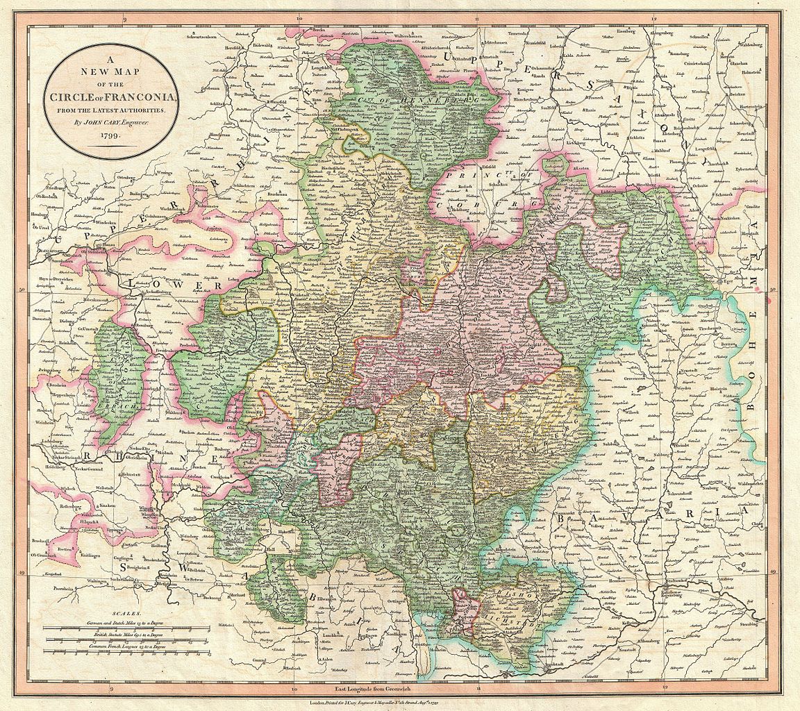
| John Cary: A New Map of the Circle of Franconia, from the Latest Authorities.
( |
||||||||||||||||||||||||||
|---|---|---|---|---|---|---|---|---|---|---|---|---|---|---|---|---|---|---|---|---|---|---|---|---|---|---|
| Tvůrce |
|
|||||||||||||||||||||||||
| Název |
A New Map of the Circle of Franconia, from the Latest Authorities. |
|||||||||||||||||||||||||
| Popis |
English: An extremely attractive example of John Cary’s 1799 map of Franconia, Germany. Covers from Upper Saxony south to Swabia, west to the Lower Rhine and west to the Bavaria. Includes the important mediaeval and renaissance center of Nuremburg. Today Franconia is a historic district and has been consolidated with Bavaria. Highly detailed with color coding according to region. Shows forests, cities, palaces, forts, roads and rivers. All in all, one of the most interesting and attractive atlas maps Franconia to appear in first years of the 19th century. Prepared in 1799 by John Cary for issue in his magnificent 1808 New Universal Atlas . |
|||||||||||||||||||||||||
| Datum | 1799 (dated) | |||||||||||||||||||||||||
| Rozměry | výška: 18,5 in (46,9 cm); šířka: 20,5 in (52 cm) | |||||||||||||||||||||||||
| Inventární číslo |
Geographicus link: Franconia-cary-1799 |
|||||||||||||||||||||||||
| Zdroj/Fotograf |
Cary, John, Cary's New Universal Atlas, containing distinct maps of all the principal states and kingdoms throughout the World. From the latest and best authorities extant. London: Printed for J. Cary, Engraver and Map-seller, No. 181, near Norfolk Street, Strand, 1808.
|
|||||||||||||||||||||||||
| Svolení (Užití tohoto souboru) |
|
|||||||||||||||||||||||||
Historie souboru
Kliknutím na datum a čas se zobrazí tehdejší verze souboru.
| Datum a čas | Náhled | Rozměry | Uživatel | Komentář | |
|---|---|---|---|---|---|
| současná | 22. 3. 2011, 12:26 | | 5 000 × 4 443 (7,44 MB) | BotMultichillT (diskuse | příspěvky) | {{subst:User:Multichill/Geographicus |link=http://www.geographicus.com/P/AntiqueMap/Franconia-cary-1799 |product_name=1799 Cary Map of Franconia, Germany ( Nuremburg ) |map_title=A New Map of the Circle of Franconia, from the Latest Authorities. |descript |
Tento soubor nemůžete přepsat.
Využití souboru
Na Commons na soubor odkazuje tato stránka:
_-_Geographicus_-_Franconia-cary-1799.jpg)
Globální využití souboru
Tento soubor využívají následující wiki:
- Využití na cs.wikipedia.org
- Využití na fr.wikipedia.org
_-_Geographicus_-_Franconia-cary-1799.jpg&oldid=821850229)