File:1800 Bardi Map of Genoa (Genova), Italy - Geographicus - Genoa-bardi-1800.jpg
Salta a la navegació
Salta a la cerca
Mida d'aquesta previsualització: 800 × 590 píxels. Altres resolucions: 320 × 236 píxels | 640 × 472 píxels | 1.024 × 755 píxels | 1.280 × 944 píxels | 2.560 × 1.889 píxels | 3.500 × 2.582 píxels.
Fitxer original (3.500 × 2.582 píxels, mida del fitxer: 2,93 Mo, tipus MIME: image/jpeg)
Llegendes
Llegendes
Afegeix una explicació d'una línia del que representa aquest fitxer
Resum
[modifica],_Italy_-_Geographicus_-_Genoa-bardi-1800.jpg&action=edit§ion=1)
| Nuova Pianta della Citta di Genova, e sue Fortificazioni con le Valli circonvicine. | ||||||
|---|---|---|---|---|---|---|
| Artista | ||||||
| Títol |
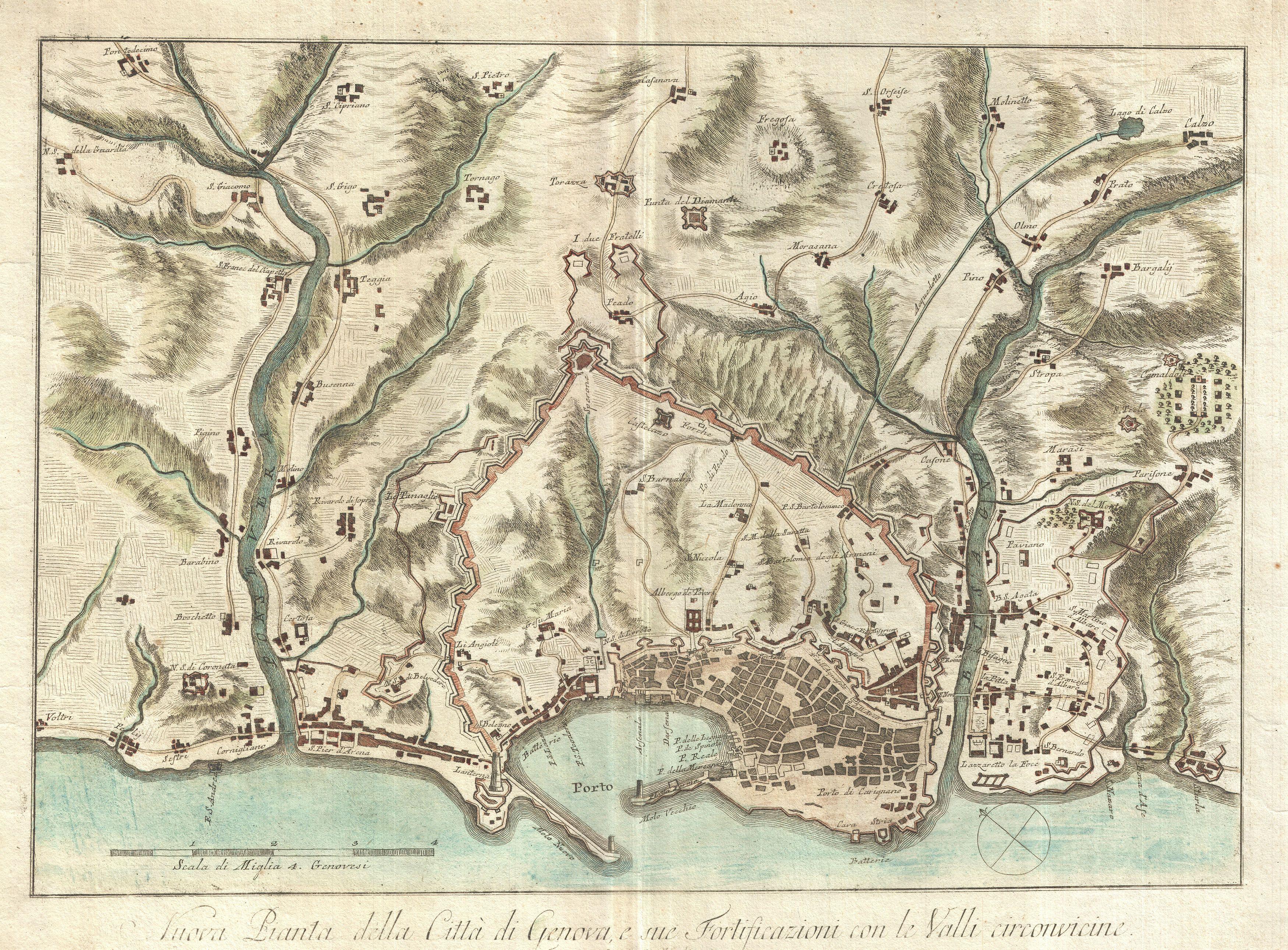
Nuova Pianta della Citta di Genova, e sue Fortificazioni con le Valli circonvicine. |
|||||
| Descripció |
English: An beautifully engraved and extremely obscure 1800 map of Genoa or Genova, Italy. Covers the walled center of Genoa and parts of the surrounding countryside as far as Voltri in the west and Calzo in the east. Detailed to the level of individual buildings with a number of churches, monasteries, convents and private villas noted. The engraver, Bardi, is best known for his intense landscapes and engravings of classical sculpture where he is a master of rendering three dimensional concepts on a two dimensional plane. Bardi's translation of this skill into the cartographic medium is exhibited here in his superb freehand rendering of topographical detail. Bardi's work is extremely scarce and we have no evidence his work ever appearing on the market - though a few maps, including this one, do appear in a couple of major institutional collections. Please take the time to admire the masterful topographical engraving as it is among the finest and most artistically sophisticated we have seen. |
|||||
| Data | 1800 (dated) | |||||
| Dimensions | altura: 15 in (38,1 cm); amplada: 20 in (50,8 cm) | |||||
| Número d'inventari |
Geographicus link: Genoa-bardi-1800 |
|||||
| Origen/Fotògraf |
|
|||||
| Permís (Com reutilitzar aquest fitxer) |
|
|||||
Historial del fitxer
Cliqueu una data/hora per veure el fitxer tal com era aleshores.
| Data/hora | Miniatura | Dimensions | Usuari/a | Comentari | |
|---|---|---|---|---|---|
| actual | 20:29, 24 març 2011 | | 3.500 × 2.582 (2,93 Mo) | BotMultichillT (discussió | contribucions) | {{subst:User:Multichill/Geographicus |link=http://www.geographicus.com/P/AntiqueMap/Genoa-bardi-1800 |product_name=1800 Bardi Map of Genoa (Genova), Italy |map_title=Nuova Pianta della Citta di Genova, e sue Fortificazioni con le Valli circonvicine. |desc |
No podeu sobreescriure aquest fitxer.
Ús del fitxer
Les 2 pàgines següents utilitzen aquest fitxer:
,_Italy_-_Geographicus_-_Genoa-bardi-1800.jpg)
Ús global del fitxer
Utilització d'aquest fitxer en altres wikis:
- Utilització a ca.wikipedia.org
- Utilització a de.wikipedia.org
- Utilització a en.wikipedia.org
- Utilització a es.wikipedia.org
- Utilització a fr.wikipedia.org
- Utilització a it.wikipedia.org
- Utilització a ko.wikipedia.org
- Utilització a lij.wikipedia.org
- Utilització a lij.wikisource.org
- Utilització a nl.wikipedia.org
- Utilització a pl.wikipedia.org
- Utilització a ru.wikipedia.org
- Utilització a tr.wikipedia.org
- Utilització a zh.wikipedia.org
,_Italy_-_Geographicus_-_Genoa-bardi-1800.jpg&oldid=744837260)