File:1806 Cary Map of Asia, Polynesia, and Australia - Geographicus - Asia-cary-1806.jpg
跳转到导航
跳转到搜索

本预览的尺寸:676 × 599像素。 其他分辨率:271 × 240像素 | 542 × 480像素 | 866 × 768像素 | 1,155 × 1,024像素 | 2,310 × 2,048像素 | 4,000 × 3,546像素。
原始文件 (4,000 × 3,546像素,文件大小:4.13 MB,MIME类型:image/jpeg)
说明
说明
添加一行文字以描述该文件所表现的内容
摘要
[编辑]
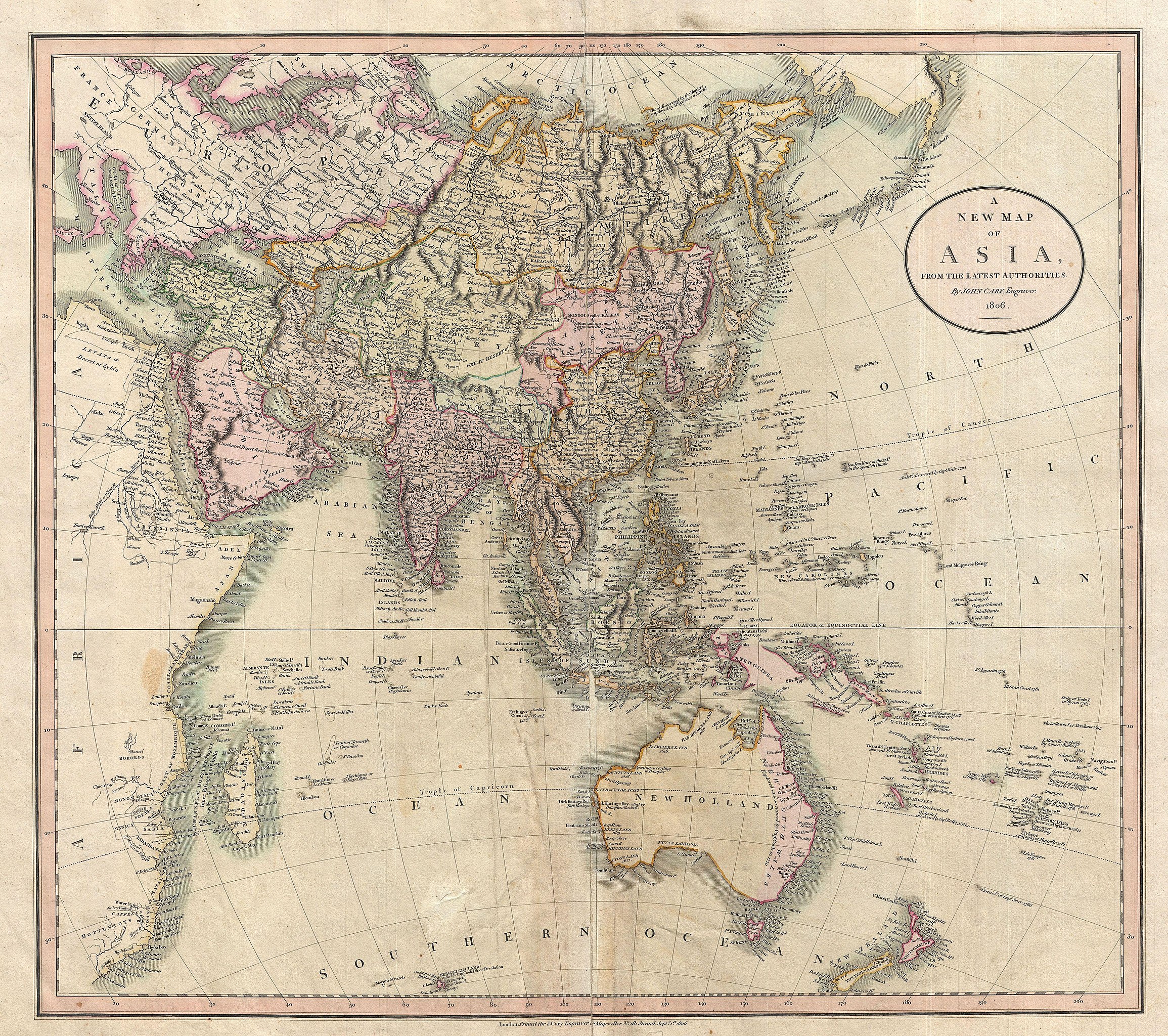
| John Cary:A New Map of Asia, From the Latest Authorities.
( |
||||||
|---|---|---|---|---|---|---|
| 艺术家 | ||||||
| 标题 |
A New Map of Asia, From the Latest Authorities. |
|||||
| 描述 |
English: This is John Cary’s stunning 1806 map of Asia, Australia, and Polynesia. Covers from the Mediterranean to the Aleutian Islands and from the Arctic to South Africa, Australia, and New Zealand. This beautifully rendered map is truly a masterpiece of engraving, with mountain ranges, lakes, deserts, and rivers excited with such precision that the result appears almost three dimensional. Cary injects astounding detail throughout with countless towns, cities, geographical features, rivers, islands and bodies of water noted. In desert regions fresh water sources are noted. In the seas certain shoals and undersea are included. In China and Manchuria the Great Wall appears. Singapore islands is shown but not specifically named. The Liakhov Islands, in northern Siberia, which some believed to be entirely composed of fossil mammoth ivory, are noted as Shore Discovered by Hunters. Published by John Cary in his 1808 Cary's New Universal Atlas . |
|||||
| 日期 | 1806年 (dated) | |||||
| 尺寸 | 高度:18.5英寸(46.9厘米);宽度:21英寸(53.3厘米) | |||||
| 登录号 |
Geographicus link: Asia-cary-1806 |
|||||
| 来源/摄影师 |
Cary, John, Cary's New Universal Atlas, containing distinct maps of all the principal states and kingdoms throughout the World. From the latest and best authorities extant. London: Printed for J. Cary, Engraver and Map-seller, No. 181, near Norfolk Street, Strand, 1808.
|
|||||
| 授权 (二次使用本文件) |
|
|||||
文件历史
点击某个日期/时间查看对应时刻的文件。
| 日期/时间 | 缩略图 | 大小 | 用户 | 备注 | |
|---|---|---|---|---|---|
| 当前 | 2011年3月24日 (四) 22:09 | | 4,000 × 3,546(4.13 MB) | BotMultichillT(留言 | 贡献) | {{subst:User:Multichill/Geographicus |link=http://www.geographicus.com/P/AntiqueMap/Asia-cary-1806 |product_name=1806 Cary Map of Asia, Polynesia, and Australia |map_title=A New Map of Asia, From the Latest Authorities. |description=This is John Cary’s |
您不可以覆盖此文件。
文件用途
全域文件用途
以下其他wiki使用此文件:
- ca.wikipedia.org上的用途
- en.wikipedia.org上的用途
- eo.wikipedia.org上的用途
- es.wikipedia.org上的用途
- fr.wikipedia.org上的用途
- id.wikipedia.org上的用途
- pt.wikipedia.org上的用途